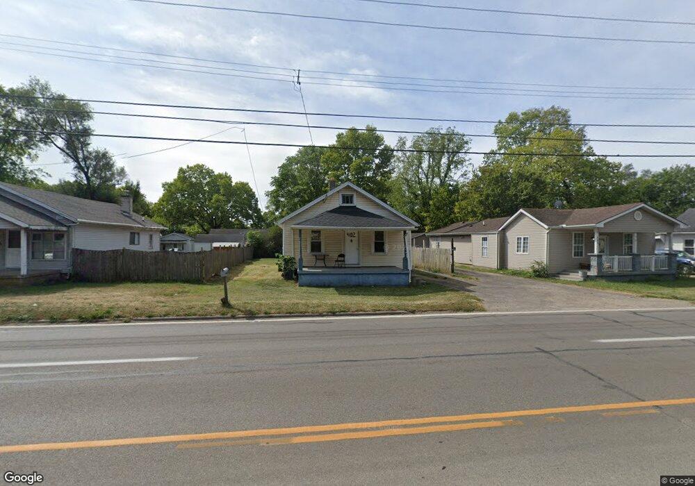
402 Oxford State Rd Middletown, OH 45044
Estimated Value: $59,000 - $153,000
2
Beds
1
Bath
960
Sq Ft
$118/Sq Ft
Est. Value
About This Home
This home is located at 402 Oxford State Rd, Middletown, OH 45044 and is currently estimated at $113,539, approximately $118 per square foot. 402 Oxford State Rd is a home located in Butler County with nearby schools including Amanda Elementary School, Highview 6th Grade Center, and Middletown Middle School.
Ownership History
Date
Name
Owned For
Owner Type
Purchase Details
Closed on
May 24, 2023
Sold by
B & M Davis Investments Llc
Bought by
Geiss Properties Llc
Current Estimated Value
Purchase Details
Closed on
Oct 3, 2018
Sold by
Davis Robert H and Davis Marla K
Bought by
B & B Davis Investments Llc
Purchase Details
Closed on
Jun 14, 2016
Sold by
Mize David C and Mize Marsha K
Bought by
Davis Robert H and Davis Marla K
Create a Home Valuation Report for This Property
The Home Valuation Report is an in-depth analysis detailing your home's value as well as a comparison with similar homes in the area
Home Values in the Area
Average Home Value in this Area
Purchase History
| Date | Buyer | Sale Price | Title Company |
|---|---|---|---|
| Geiss Properties Llc | $30,000 | None Listed On Document | |
| Geiss Properties Llc | $30,000 | None Listed On Document | |
| B & B Davis Investments Llc | -- | None Available | |
| Davis Robert H | $20,000 | None Available |
Source: Public Records
Tax History Compared to Growth
Tax History
| Year | Tax Paid | Tax Assessment Tax Assessment Total Assessment is a certain percentage of the fair market value that is determined by local assessors to be the total taxable value of land and additions on the property. | Land | Improvement |
|---|---|---|---|---|
| 2024 | $1,331 | $21,840 | $2,930 | $18,910 |
| 2023 | $1,228 | $21,840 | $2,930 | $18,910 |
| 2022 | $1,019 | $15,530 | $2,930 | $12,600 |
| 2021 | $992 | $15,530 | $2,930 | $12,600 |
| 2020 | $1,030 | $15,530 | $2,930 | $12,600 |
| 2019 | $988 | $13,920 | $2,840 | $11,080 |
| 2018 | $1,008 | $13,920 | $2,840 | $11,080 |
| 2017 | $901 | $13,920 | $2,840 | $11,080 |
| 2016 | $984 | $12,960 | $2,840 | $10,120 |
| 2015 | $486 | $12,960 | $2,840 | $10,120 |
| 2014 | $1,099 | $12,960 | $2,840 | $10,120 |
| 2013 | $1,099 | $16,160 | $5,670 | $10,490 |
Source: Public Records
Map
Nearby Homes
- 3109 Locust St
- 720 Diamond Loop
- 3620 S Main St
- 0 Jackson St Unit 895859
- 0 Jackson St Unit 1780028
- 580 Diamond Loop
- 1102 Forrer St
- 514 Granada Ave
- 3004 Judy Dr
- 712 Buena Ave
- 2004 Minnesota St
- 3209 Rufus St
- 3113 Rufus St
- 3107 Rufus St
- 707 Nathan Dr
- 2900 Morgan St
- 6631 Hamilton Middletown Rd
- 1602 Oxford State Rd
- 1613 Sheridan Ave
- 6328 Sycamore Rd
- 404 Oxford State Rd
- 344 Oxford State Rd
- 342 Oxford State Rd
- 408 Oxford State Rd
- 407 Oxford State Rd
- 343 Locust St
- 403 Oxford State Rd
- 340 Oxford State Rd
- 341 Oxford State Rd
- 409 Oxford State Rd
- 339 Oxford State Rd
- 339 Oxford State Rd
- 337 Oxford State Rd
- 332 Oxford State Rd
- 3201 Locust St
- 415 Oxford State Rd
- 415 Oxford State Rd
- 415 Oxford State Rd
- 402 Staton St
- 400 Oxford State Rd