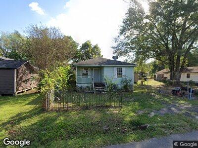
4023 Doris St Shreveport, LA 71109
Mooretown and Hollywood Heights NeighborhoodEstimated Value: $29,000 - $46,000
4
Beds
1
Bath
1,122
Sq Ft
$35/Sq Ft
Est. Value
About This Home
This home is located at 4023 Doris St, Shreveport, LA 71109 and is currently estimated at $39,751, approximately $35 per square foot. 4023 Doris St is a home located in Caddo Parish with nearby schools including Oak Park Elementary School, Judson Fundamental Elementary School, and Fairfield Magnet School.
Ownership History
Date
Name
Owned For
Owner Type
Purchase Details
Closed on
Mar 19, 2025
Sold by
Parish Of Caddo
Bought by
Mid-State Trust and Us Bank Na
Current Estimated Value
Purchase Details
Closed on
Jul 22, 2020
Sold by
Caddo County Sheriff
Bought by
Us Bank Na
Purchase Details
Closed on
Apr 17, 2018
Sold by
Irb Properties Llc
Bought by
Mitchell Jessie C and Mitchell Cloteil M
Purchase Details
Closed on
Nov 16, 2010
Sold by
The Parish Of Caddo
Bought by
Irb Properties Llc
Create a Home Valuation Report for This Property
The Home Valuation Report is an in-depth analysis detailing your home's value as well as a comparison with similar homes in the area
Home Values in the Area
Average Home Value in this Area
Purchase History
| Date | Buyer | Sale Price | Title Company |
|---|---|---|---|
| Mid-State Trust | $20,000 | None Listed On Document | |
| Us Bank Na | $26,667 | None Available | |
| Mitchell Jessie C | -- | None Available | |
| Irb Properties Llc | $2,000 | None Available |
Source: Public Records
Mortgage History
| Date | Status | Borrower | Loan Amount |
|---|---|---|---|
| Previous Owner | Jackson Mayquie Nniacud | $22,500 |
Source: Public Records
Tax History Compared to Growth
Tax History
| Year | Tax Paid | Tax Assessment Tax Assessment Total Assessment is a certain percentage of the fair market value that is determined by local assessors to be the total taxable value of land and additions on the property. | Land | Improvement |
|---|---|---|---|---|
| 2024 | $364 | $2,332 | $365 | $1,967 |
| 2023 | $369 | $2,315 | $348 | $1,967 |
| 2022 | $369 | $2,315 | $348 | $1,967 |
| 2021 | $363 | $2,315 | $348 | $1,967 |
| 2020 | $363 | $2,315 | $348 | $1,967 |
| 2019 | $374 | $2,315 | $348 | $1,967 |
| 2018 | $298 | $2,315 | $348 | $1,967 |
| 2017 | $380 | $2,315 | $348 | $1,967 |
| 2015 | $355 | $2,740 | $350 | $2,390 |
| 2014 | $358 | $2,740 | $350 | $2,390 |
| 2013 | -- | $2,740 | $350 | $2,390 |
Source: Public Records
Map
Nearby Homes
- 3828 Cleveland St
- 5600 Norton St
- 4310 Saint Louis Ave
- 4302 Illinois Ave
- 3529 Palm Rd
- 3534 Pleasant Dr
- 4209 Greenwood Rd
- 6208 Jewella Ave
- 4027 Marion Place
- 3421 Clarke Blvd
- 3938 Mayfield St
- 4136 Mayfield St
- 4130 Mayfield St
- 0 Oakcrest St
- 4228 Barbara Ave
- 4513 Rochester Dr
- 3610 Sanders St
- 4138 Powell St
- 4209 Lamar Ave
- 3256 Midway St