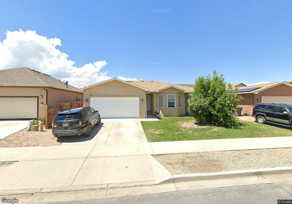
403 1/2 29 1/2 Rd Grand Junction, CO 81504
Southeast Grand Junction NeighborhoodEstimated Value: $371,000 - $387,000
3
Beds
2
Baths
1,519
Sq Ft
$248/Sq Ft
Est. Value
About This Home
This home is located at 403 1/2 29 1/2 Rd, Grand Junction, CO 81504 and is currently estimated at $376,154, approximately $247 per square foot. 403 1/2 29 1/2 Rd is a home located in Mesa County with nearby schools including Pear Park Elementary School, Bookcliff Middle School, and East Middle School.
Ownership History
Date
Name
Owned For
Owner Type
Purchase Details
Closed on
May 1, 2023
Sold by
Laduke Corbett M and Laduke Jennifer D
Bought by
Campbell Eric A and Lane Kelly M
Current Estimated Value
Home Financials for this Owner
Home Financials are based on the most recent Mortgage that was taken out on this home.
Original Mortgage
$13,314
Outstanding Balance
$957
Interest Rate
6.6%
Mortgage Type
New Conventional
Estimated Equity
$375,197
Purchase Details
Closed on
Sep 12, 2007
Sold by
Tml Enterprises Inc
Bought by
Laduke Corbett and Laduke Jennifer D
Home Financials for this Owner
Home Financials are based on the most recent Mortgage that was taken out on this home.
Original Mortgage
$183,750
Interest Rate
6.45%
Mortgage Type
Purchase Money Mortgage
Create a Home Valuation Report for This Property
The Home Valuation Report is an in-depth analysis detailing your home's value as well as a comparison with similar homes in the area
Home Values in the Area
Average Home Value in this Area
Purchase History
| Date | Buyer | Sale Price | Title Company |
|---|---|---|---|
| Campbell Eric A | $339,000 | Htc | |
| Laduke Corbett | $245,000 | Fahtco |
Source: Public Records
Mortgage History
| Date | Status | Borrower | Loan Amount |
|---|---|---|---|
| Open | Campbell Eric A | $13,314 | |
| Open | Campbell Eric A | $332,859 | |
| Previous Owner | Laduke Corbett | $183,750 |
Source: Public Records
Tax History Compared to Growth
Tax History
| Year | Tax Paid | Tax Assessment Tax Assessment Total Assessment is a certain percentage of the fair market value that is determined by local assessors to be the total taxable value of land and additions on the property. | Land | Improvement |
|---|---|---|---|---|
| 2024 | $1,361 | $19,250 | $3,490 | $15,760 |
| 2023 | $1,361 | $19,250 | $3,490 | $15,760 |
| 2022 | $1,212 | $16,820 | $4,170 | $12,650 |
| 2021 | $1,217 | $17,310 | $4,290 | $13,020 |
| 2020 | $1,037 | $15,100 | $3,220 | $11,880 |
| 2019 | $981 | $15,100 | $3,220 | $11,880 |
| 2018 | $903 | $12,670 | $2,520 | $10,150 |
| 2017 | $900 | $12,670 | $2,520 | $10,150 |
| 2016 | $873 | $13,810 | $2,790 | $11,020 |
| 2015 | $884 | $13,810 | $2,790 | $11,020 |
| 2014 | $779 | $12,260 | $1,670 | $10,590 |
Source: Public Records
Map
Nearby Homes
- 408 29 1 2 Rd
- 2961 Red Cloud Ln Unit A
- 433 Donogal Dr
- 421 Brealyn Ct
- 2931 Paula Ln Unit 4
- 2931 Paula Ln Unit 3
- 2972 Luke St
- 2910 D Rd Unit 3.2 AC
- 2910 D Rd Unit 1 Acre
- 2910 D Rd
- 2910 D Rd Unit 1 AC
- 408 Marianne Dr
- 410 Marianne Dr
- 432 Marianne Dr
- 374 29 5 8 Rd
- 359 29 5 8 Rd
- 2971 1/2 D 1 2 Rd
- 2979 D 1 2 Rd
- 442 Florence Rd
- 2986 Clarinet Ln
- 403 1/2 29 1 2 Rd
- 403 29 1 2 Rd
- 405 29 1/2 Rd
- 403 29 1/2 Rd
- 404 Chert Dr
- 404.5 Chert Dr
- 2946 Chinto Dr
- 404 1/2 Chert Dr
- 2945 Red Cloud Ln
- 2943 Red Cloud Ln
- 406 29 1 2
- 406 29 1/2 Rd
- 406 29 1 2 Rd
- 408 29 1/2 Rd
- 408 1/2 29 1/2 Rd
- 2949 Chinto Dr
- 0 Chinto Dr Unit 599003
- 0 Chinto Dr Unit 602256
- 0 Chinto Dr Unit 636359
- 0 Chinto Dr Unit 636401