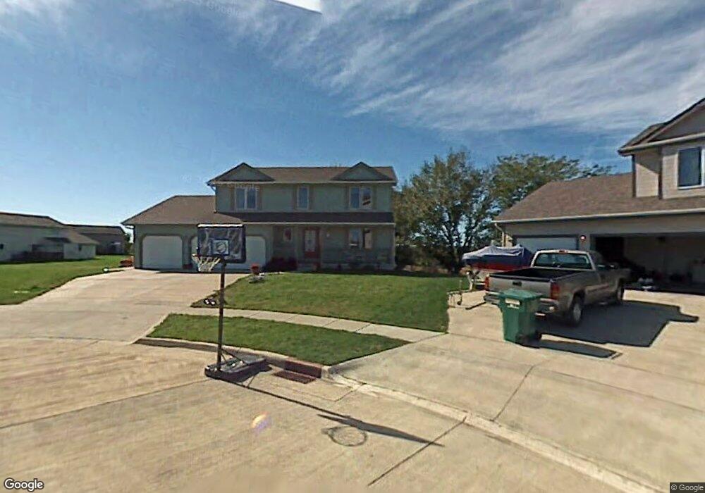
403 Molly Ct Runnells, IA 50237
Estimated Value: $343,000 - $435,000
3
Beds
3
Baths
2,016
Sq Ft
$187/Sq Ft
Est. Value
About This Home
This home is located at 403 Molly Ct, Runnells, IA 50237 and is currently estimated at $377,501, approximately $187 per square foot. 403 Molly Ct is a home located in Polk County with nearby schools including Runnells Elementary School, Southeast Polk Spring Creek- 6th Grade, and Southeast Polk Junior High School.
Ownership History
Date
Name
Owned For
Owner Type
Purchase Details
Closed on
Apr 25, 2007
Sold by
Lessard Willie J and Lessard Sharon K
Bought by
Lessard William J and Lessard Jennifer L
Current Estimated Value
Home Financials for this Owner
Home Financials are based on the most recent Mortgage that was taken out on this home.
Original Mortgage
$203,500
Outstanding Balance
$123,380
Interest Rate
6.2%
Mortgage Type
Purchase Money Mortgage
Estimated Equity
$254,121
Purchase Details
Closed on
Jul 26, 2004
Sold by
Harvey Christopher L and Harvey Jennifer L
Bought by
Lessard Willie J and Lessard Sharon K
Home Financials for this Owner
Home Financials are based on the most recent Mortgage that was taken out on this home.
Original Mortgage
$198,360
Interest Rate
6.4%
Mortgage Type
Credit Line Revolving
Create a Home Valuation Report for This Property
The Home Valuation Report is an in-depth analysis detailing your home's value as well as a comparison with similar homes in the area
Purchase History
| Date | Buyer | Sale Price | Title Company |
|---|---|---|---|
| Lessard William J | $218,500 | Itc | |
| Lessard Willie J | $208,500 | -- |
Source: Public Records
Mortgage History
| Date | Status | Borrower | Loan Amount |
|---|---|---|---|
| Open | Lessard William J | $203,500 | |
| Previous Owner | Lessard Willie J | $198,360 |
Source: Public Records
Tax History
| Year | Tax Paid | Tax Assessment Tax Assessment Total Assessment is a certain percentage of the fair market value that is determined by local assessors to be the total taxable value of land and additions on the property. | Land | Improvement |
|---|---|---|---|---|
| 2025 | $6,048 | $396,500 | $41,200 | $355,300 |
| 2024 | $6,048 | $355,700 | $36,400 | $319,300 |
| 2023 | $5,832 | $355,700 | $36,400 | $319,300 |
| 2022 | $5,758 | $300,400 | $31,500 | $268,900 |
| 2021 | $5,402 | $300,400 | $31,500 | $268,900 |
| 2020 | $5,312 | $269,600 | $28,200 | $241,400 |
| 2019 | $5,150 | $269,600 | $28,200 | $241,400 |
| 2018 | $5,158 | $243,500 | $24,700 | $218,800 |
| 2017 | $5,270 | $243,500 | $24,700 | $218,800 |
| 2016 | $5,244 | $223,500 | $20,600 | $202,900 |
| 2015 | $5,244 | $223,500 | $20,600 | $202,900 |
| 2014 | $5,134 | $220,100 | $19,900 | $200,200 |
Source: Public Records
Map
Nearby Homes
- 303 W Mckinney St
- 203 Brown St
- 12028 SE 64th Ave
- 3333 220th Ave
- 3380 SE 96th St
- 2493 SE 108th St
- 2360 SE 108th St
- 0 S 128th Ave W
- 10579 W 129th St S
- 410 N Vine St
- 1462 108th St SE
- 7930 SE Vandalia Dr
- 2456 SE 88th St
- 7820 SE Vandalia Dr
- 3350 SE 82nd St
- 24479 Elthon Place
- 2496 SE 83rd Ct
- 3356 SE 82nd St
- 2511 SE 82nd St
- 5825 G24 Hwy
Your Personal Tour Guide
Ask me questions while you tour the home.