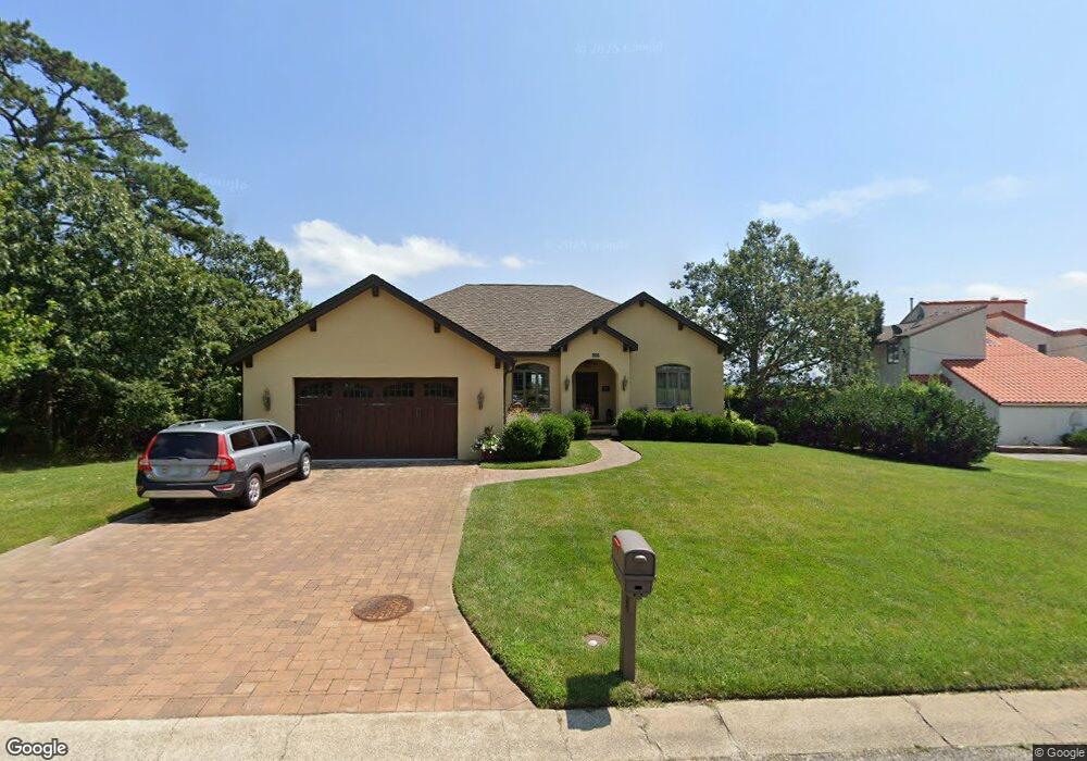
404 Burning Tree Blvd Absecon, NJ 08201
Estimated Value: $479,000 - $664,000
Studio
--
Bath
2,099
Sq Ft
$269/Sq Ft
Est. Value
About This Home
This home is located at 404 Burning Tree Blvd, Absecon, NJ 08201 and is currently estimated at $563,846, approximately $268 per square foot. 404 Burning Tree Blvd is a home located in Atlantic County with nearby schools including H. Ashton Marsh Elementary School, Emma C. Attales Middle School, and Life Point Academy/ Life Point Church.
Ownership History
Date
Name
Owned For
Owner Type
Purchase Details
Closed on
Dec 16, 2013
Sold by
Magolda Linda
Bought by
Voermans John M and Voermans Paule J
Current Estimated Value
Purchase Details
Closed on
Jul 20, 2009
Sold by
Vizzi Richard R
Bought by
Magolda Linda
Purchase Details
Closed on
Oct 28, 2008
Sold by
Rosenberg Spencer and Rosenberg Adele P
Bought by
Vizzi Richard R
Purchase Details
Closed on
Feb 9, 2005
Sold by
Mason Art Reatly Company Inc
Bought by
Rosenberg Spencer and Rosenberg Adele
Purchase Details
Closed on
Nov 12, 1992
Sold by
Absecon Shores Partbership
Bought by
Mason/Art Realty Co Inc
Create a Home Valuation Report for This Property
The Home Valuation Report is an in-depth analysis detailing your home's value as well as a comparison with similar homes in the area
Home Values in the Area
Average Home Value in this Area
Purchase History
| Date | Buyer | Sale Price | Title Company |
|---|---|---|---|
| Voermans John M | $80,000 | Surety Title | |
| Magolda Linda | $100,000 | None Available | |
| Vizzi Richard R | $50,000 | None Available | |
| Rosenberg Spencer | -- | -- | |
| Rosenberg Spencer | -- | -- | |
| Mason/Art Realty Co Inc | $60,000 | -- |
Source: Public Records
Tax History
| Year | Tax Paid | Tax Assessment Tax Assessment Total Assessment is a certain percentage of the fair market value that is determined by local assessors to be the total taxable value of land and additions on the property. | Land | Improvement |
|---|---|---|---|---|
| 2025 | $11,005 | $328,900 | $130,400 | $198,500 |
| 2024 | $11,005 | $328,900 | $130,400 | $198,500 |
Source: Public Records
Map
Nearby Homes
- 202 Burning Tree Blvd
- 172 E Faunce Landing Rd
- 194 N Shore Rd
- 40 N Shore Rd
- 11 Lisbon Ave
- 36 E Lee Ave
- 161 E Wyoming Ave
- 107 W Church St
- 15 W Bolton Ave
- 175 New Jersey Ave
- 14 Kesler Ave
- 4 E Curran Dr
- 236 E Wyoming Ave
- 399 Pitney Rd
- 1513 Ocean Ave
- 1508 7th Ave
- 1427 Ocean Ave
- 130 Davis Ave
- 123 Bayview Dr
- 1403 N Franklin Blvd
- 402 Burning Tree Blvd
- 503 Burning Tree Blvd
- 408 Burning Tree Blvd
- 400 Burning Tree Blvd
- 403 Burning Tree Blvd
- 407 Burning Tree Blvd
- 401 Burning Tree Blvd
- 410 Burning Tree Blvd
- 111 Cedar Hill Dr
- 404 Cynwyd Dr
- 406 Cynwyd Dr
- 402 Cynwyd Dr
- 408 Cynwyd Dr
- 719 Birch Cir
- 399 Burning Tree Blvd
- 500 Burning Tree Blvd
- 501 Burning Tree Blvd
- 308 Cynwyd Dr
- 110 Cedar Hill Dr
- 403 Cynwyd Dr
Your Personal Tour Guide
Ask me questions while you tour the home.