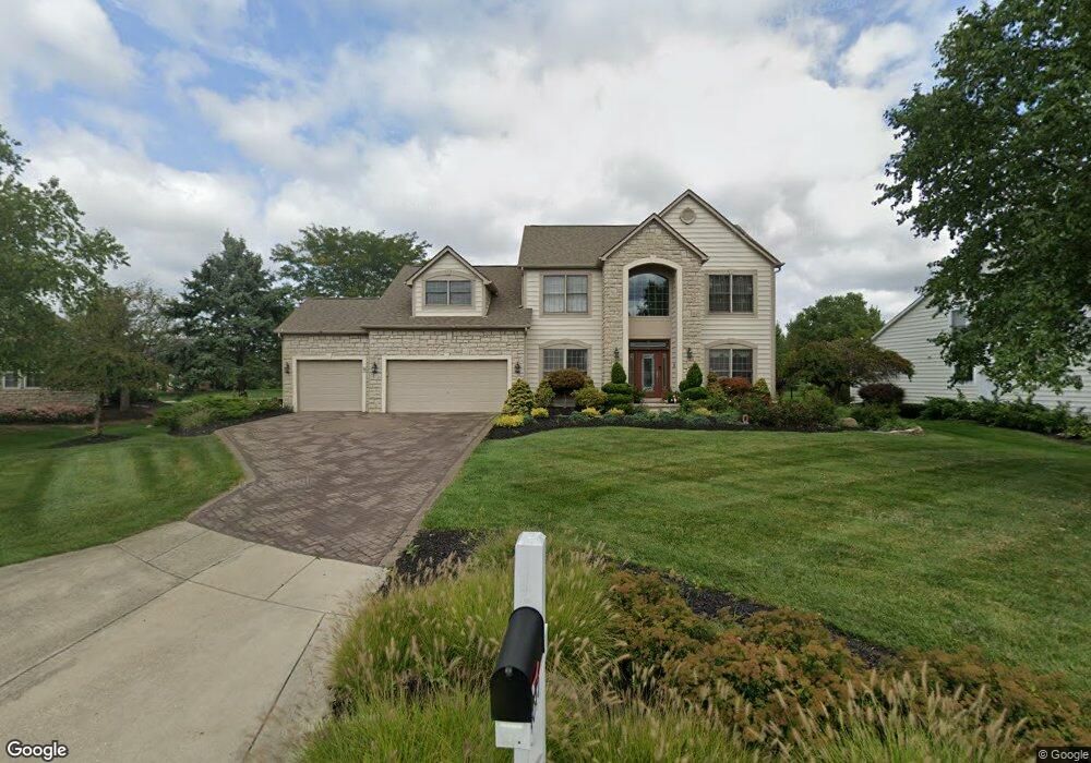
4040 Kodiak Ct Powell, OH 43065
Liberty Township NeighborhoodEstimated Value: $628,000 - $713,000
4
Beds
4
Baths
3,770
Sq Ft
$179/Sq Ft
Est. Value
About This Home
This home is located at 4040 Kodiak Ct, Powell, OH 43065 and is currently estimated at $674,400, approximately $178 per square foot. 4040 Kodiak Ct is a home located in Delaware County with nearby schools including Scioto Ridge Elementary School, Olentangy Liberty Middle School, and Olentangy Liberty High School.
Ownership History
Date
Name
Owned For
Owner Type
Purchase Details
Closed on
Mar 12, 2019
Sold by
Matlock William E and Matlock Effie J
Bought by
Matlock William E and Matlock Effie J
Current Estimated Value
Home Financials for this Owner
Home Financials are based on the most recent Mortgage that was taken out on this home.
Original Mortgage
$273,000
Outstanding Balance
$239,525
Interest Rate
4.3%
Mortgage Type
New Conventional
Estimated Equity
$434,875
Purchase Details
Closed on
Oct 28, 2004
Sold by
Matlock Jettye C
Bought by
Matlock William E
Purchase Details
Closed on
Mar 29, 1999
Sold by
Dominion Homes Inc
Bought by
Matlock William E Jettye C
Home Financials for this Owner
Home Financials are based on the most recent Mortgage that was taken out on this home.
Original Mortgage
$216,700
Interest Rate
6.85%
Mortgage Type
New Conventional
Create a Home Valuation Report for This Property
The Home Valuation Report is an in-depth analysis detailing your home's value as well as a comparison with similar homes in the area
Home Values in the Area
Average Home Value in this Area
Purchase History
| Date | Buyer | Sale Price | Title Company |
|---|---|---|---|
| Matlock William E | -- | Mortgage Information Svcs In | |
| Matlock William E | -- | None Available | |
| Matlock William E Jettye C | $270,875 | -- |
Source: Public Records
Mortgage History
| Date | Status | Borrower | Loan Amount |
|---|---|---|---|
| Open | Matlock William E | $273,000 | |
| Closed | Matlock William E Jettye C | $216,700 |
Source: Public Records
Tax History Compared to Growth
Tax History
| Year | Tax Paid | Tax Assessment Tax Assessment Total Assessment is a certain percentage of the fair market value that is determined by local assessors to be the total taxable value of land and additions on the property. | Land | Improvement |
|---|---|---|---|---|
| 2024 | $10,011 | $190,860 | $39,520 | $151,340 |
| 2023 | $9,811 | $190,860 | $39,520 | $151,340 |
| 2022 | $8,496 | $136,820 | $25,730 | $111,090 |
| 2021 | $8,549 | $136,820 | $25,730 | $111,090 |
| 2020 | $8,590 | $136,820 | $25,730 | $111,090 |
| 2019 | $7,711 | $128,600 | $25,730 | $102,870 |
| 2018 | $7,747 | $128,600 | $25,730 | $102,870 |
| 2017 | $7,103 | $113,860 | $21,180 | $92,680 |
| 2016 | $7,232 | $113,860 | $21,180 | $92,680 |
| 2015 | $6,540 | $113,860 | $21,180 | $92,680 |
| 2014 | $6,630 | $113,860 | $21,180 | $92,680 |
| 2013 | $6,610 | $111,170 | $21,180 | $89,990 |
Source: Public Records
Map
Nearby Homes
- 3899 Hampshire Ave
- 3801 Orchard Way
- 9529 Wayne Brown Dr
- 9406 Cadogan Ct
- 3862 Foresta Grand Dr
- 9182 Marlebury End
- 9038 Courtside Ln
- 3750 Echo Place Unit 3750
- 4162 Pyke Dr
- 3717 Stoneway Point Unit 3717
- 3697 Stoneway Point Unit 83697
- 9461 Waterford Dr
- 384 Park Woods Ln
- 3751 Stoneway Point
- 324 Park Woods Ln
- 3603 Stoneway Point
- 3669 Stoneway Point Unit 53669
- 4003 Laurel Valley Dr
- 9545 Gibson Dr
- 8778 Linksway Dr
- 4060 Kodiak Ct
- 4020 Kodiak Ct
- 9330 Auburn Ave
- 4080 Kodiak Ct
- 4014 Kodiak Ct
- 4051 Kodiak Ct
- 4031 Kodiak Ct
- 9372 Auburn Ave
- 3987 Mead Dr
- 3987 Mead Dr Unit 3362
- 9278 Big Bear Ave
- 9298 Auburn Ct
- 9386 Auburn Ave
- 4008 Ayshire Ct
- 4026 Ayshire Ct
- 9333 Auburn Ave
- 9349 Auburn Ave
- 3961 Mead Dr
- 9361 Auburn Ave
- 3994 Ayshire Ct