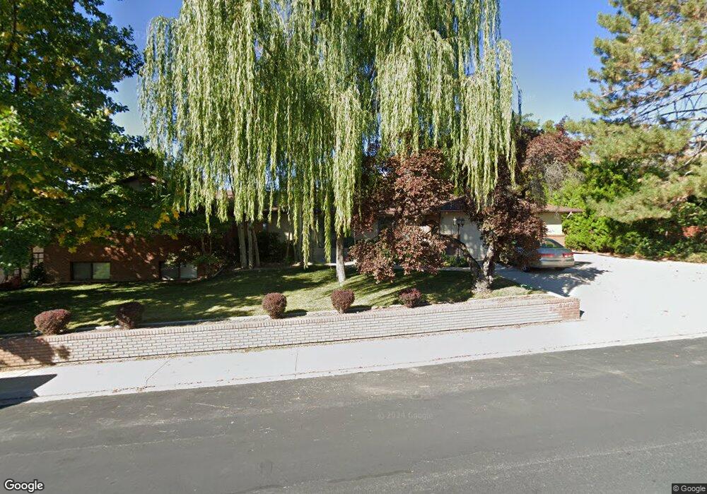
405 E 4450 N Provo, UT 84604
Rock Canyon NeighborhoodEstimated Value: $668,000 - $773,407
6
Beds
4
Baths
2,304
Sq Ft
$315/Sq Ft
Est. Value
About This Home
This home is located at 405 E 4450 N, Provo, UT 84604 and is currently estimated at $726,602, approximately $315 per square foot. 405 E 4450 N is a home located in Utah County with nearby schools including Canyon Crest Elementary School, Centennial Middle School, and Timpview High School.
Ownership History
Date
Name
Owned For
Owner Type
Purchase Details
Closed on
Jan 22, 2021
Sold by
Cannon Doug and Cannon Beverly A
Bought by
Cannon Douglas E and Cannon Beverly A
Current Estimated Value
Home Financials for this Owner
Home Financials are based on the most recent Mortgage that was taken out on this home.
Original Mortgage
$333,100
Outstanding Balance
$297,083
Interest Rate
2.67%
Mortgage Type
New Conventional
Estimated Equity
$429,519
Purchase Details
Closed on
May 10, 2005
Sold by
Harris Wilford and Harris Joy K
Bought by
Cannon Doug and Cannon Beverly A
Create a Home Valuation Report for This Property
The Home Valuation Report is an in-depth analysis detailing your home's value as well as a comparison with similar homes in the area
Home Values in the Area
Average Home Value in this Area
Purchase History
| Date | Buyer | Sale Price | Title Company |
|---|---|---|---|
| Cannon Douglas E | -- | Vanguard Title Ins Agcy Llc | |
| Cannon Doug | -- | Security Title & Abstract |
Source: Public Records
Mortgage History
| Date | Status | Borrower | Loan Amount |
|---|---|---|---|
| Open | Cannon Douglas E | $333,100 |
Source: Public Records
Tax History Compared to Growth
Tax History
| Year | Tax Paid | Tax Assessment Tax Assessment Total Assessment is a certain percentage of the fair market value that is determined by local assessors to be the total taxable value of land and additions on the property. | Land | Improvement |
|---|---|---|---|---|
| 2025 | $4,225 | $416,130 | $331,400 | $425,200 |
| 2024 | $4,225 | $415,910 | $0 | $0 |
| 2023 | $4,138 | $401,555 | $0 | $0 |
| 2022 | $4,116 | $402,765 | $0 | $0 |
| 2021 | $3,148 | $537,200 | $224,300 | $312,900 |
| 2020 | $3,086 | $493,700 | $186,900 | $306,800 |
| 2019 | $2,967 | $493,700 | $186,900 | $306,800 |
| 2018 | $2,859 | $482,500 | $175,700 | $306,800 |
| 2017 | $2,743 | $254,375 | $0 | $0 |
| 2016 | $3,029 | $261,745 | $0 | $0 |
| 2015 | $2,647 | $231,220 | $0 | $0 |
| 2014 | $2,206 | $200,860 | $0 | $0 |
Source: Public Records
Map
Nearby Homes
- 645 Foothill Dr
- 4601 Foothill Dr
- 4161 N Canyon Rd Unit 2
- 924 Redford Dr
- 221 E 4735 N
- 209 E 4735 N
- 4606 Brookshire Cir
- 299 E 4000 N
- 3985 N 850 St E
- 981 Waterford Dr Unit 5&6
- 4246 N Stonecrossing
- 4299 Ivy Ln
- 4365 Bedford Dr
- 4612 N Bristol Cir
- 5005 N Edgewood Dr Unit 310
- 3711 N Canyon Rd
- 4077 N Devonshire Cir
- 282 W 4020 N
- 3702 N 920 E
- 3943 Foothill Dr