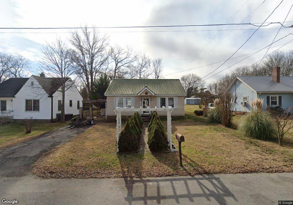
405 Forrest St Franklin, TN 37064
Central Franklin NeighborhoodEstimated Value: $390,000 - $544,000
Studio
1
Bath
1,008
Sq Ft
$437/Sq Ft
Est. Value
About This Home
This home is located at 405 Forrest St, Franklin, TN 37064 and is currently estimated at $440,561, approximately $437 per square foot. 405 Forrest St is a home located in Williamson County with nearby schools including Franklin Elementary School, Freedom Intermediate School, and Freedom Middle School.
Ownership History
Date
Name
Owned For
Owner Type
Purchase Details
Closed on
Mar 10, 1999
Sold by
Ragsdale Raymond E
Bought by
Derryberry William Michael and Derryberry Helen Minns
Current Estimated Value
Home Financials for this Owner
Home Financials are based on the most recent Mortgage that was taken out on this home.
Original Mortgage
$55,200
Outstanding Balance
$13,054
Interest Rate
6.73%
Estimated Equity
$427,507
Create a Home Valuation Report for This Property
The Home Valuation Report is an in-depth analysis detailing your home's value as well as a comparison with similar homes in the area
Home Values in the Area
Average Home Value in this Area
Purchase History
| Date | Buyer | Sale Price | Title Company |
|---|---|---|---|
| Derryberry William Michael | $69,000 | -- |
Source: Public Records
Mortgage History
| Date | Status | Borrower | Loan Amount |
|---|---|---|---|
| Open | Derryberry William Michael | $55,200 |
Source: Public Records
Tax History
| Year | Tax Paid | Tax Assessment Tax Assessment Total Assessment is a certain percentage of the fair market value that is determined by local assessors to be the total taxable value of land and additions on the property. | Land | Improvement |
|---|---|---|---|---|
| 2025 | -- | $110,350 | $77,200 | $33,150 |
| 2024 | -- | $63,800 | $33,750 | $30,050 |
| 2023 | $0 | $63,800 | $33,750 | $30,050 |
| 2022 | $1,736 | $63,800 | $33,750 | $30,050 |
| 2021 | $1,736 | $63,800 | $33,750 | $30,050 |
| 2020 | $1,204 | $37,325 | $15,000 | $22,325 |
| 2019 | $1,204 | $37,325 | $15,000 | $22,325 |
| 2018 | $1,178 | $37,325 | $15,000 | $22,325 |
| 2017 | $1,159 | $37,325 | $15,000 | $22,325 |
| 2016 | $1,156 | $37,325 | $15,000 | $22,325 |
Source: Public Records
Map
Nearby Homes
- 1191 W Main St
- 1164 Brookwood Ave
- 503 N Petway St
- 6057 Stone Cliff Ln
- 6065 Stone Cliff Ln Unit Tr 7
- 6065 Stone Cliff Ln
- 6057 Stone Cliff Ln Unit Tr 6
- 804 W End Cir
- 355 Natchez St
- 128 Brilliantine Cir
- 1023 Benelli Park Ct
- 1319 W Main St Unit 108
- 1319 W Main St Unit 104
- 1319 W Main St Unit 303
- 1319 W Main St Unit 105
- 230 11th Ave S
- 704 W End Cir
- 312 Everbright St Unit B
- 1100 W Main St Unit F5
- 308 Everbright Ave
- 403 Forrest St
- 407 Forrest St
- 1210 W Main St
- 409 Forrest St
- 1216 W Main St
- 406 Forrest St
- 1319 W Main St
- 1222 W Main St
- 408 Forrest St
- 413 Forrest St
- 408 S Petway St
- 415 Forrest St
- 415 Forrest St Unit 1
- 412 Forrest St
- 412 S Petway St
- 417 Forrest St
- 417 Forrest St Unit B
- 417 Forrest St Unit A
- 1234 W Main St
- 417 Forrest St #B Unit B
Your Personal Tour Guide
Ask me questions while you tour the home.