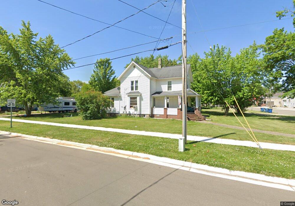
405 W Chicago St Bronson, MI 49028
Estimated Value: $184,000 - $230,000
4
Beds
1
Bath
1,746
Sq Ft
$114/Sq Ft
Est. Value
About This Home
This home is located at 405 W Chicago St, Bronson, MI 49028 and is currently estimated at $199,426, approximately $114 per square foot. 405 W Chicago St is a home located in Branch County with nearby schools including Ryan Elementary School, Anderson Elementary School, and Bronson Junior/Senior High School.
Ownership History
Date
Name
Owned For
Owner Type
Purchase Details
Closed on
Dec 28, 2023
Sold by
Clemens Gerald E
Bought by
State Line Cryogenics Llc
Current Estimated Value
Purchase Details
Closed on
Jul 30, 2008
Sold by
Rothrock Timothy A and Rothrock Patricia E
Bought by
Jeffries James D
Home Financials for this Owner
Home Financials are based on the most recent Mortgage that was taken out on this home.
Original Mortgage
$81,100
Interest Rate
6.5%
Mortgage Type
Purchase Money Mortgage
Purchase Details
Closed on
Nov 23, 1998
Create a Home Valuation Report for This Property
The Home Valuation Report is an in-depth analysis detailing your home's value as well as a comparison with similar homes in the area
Purchase History
| Date | Buyer | Sale Price | Title Company |
|---|---|---|---|
| State Line Cryogenics Llc | $34,150 | None Listed On Document | |
| Jeffries James D | $78,000 | Branch County Abstract & Tit | |
| -- | $64,500 | -- |
Source: Public Records
Mortgage History
| Date | Status | Borrower | Loan Amount |
|---|---|---|---|
| Previous Owner | Jeffries James D | $81,100 |
Source: Public Records
Tax History
| Year | Tax Paid | Tax Assessment Tax Assessment Total Assessment is a certain percentage of the fair market value that is determined by local assessors to be the total taxable value of land and additions on the property. | Land | Improvement |
|---|---|---|---|---|
| 2025 | $1,733 | $91,800 | $0 | $0 |
| 2024 | $16 | $90,600 | $0 | $0 |
| 2023 | $1,012 | $72,500 | $0 | $0 |
| 2022 | $1,600 | $61,300 | $0 | $0 |
| 2020 | -- | $51,300 | $0 | $0 |
| 2019 | -- | $45,600 | $0 | $0 |
| 2018 | -- | $38,600 | $0 | $0 |
| 2017 | -- | $37,900 | $0 | $0 |
| 2016 | -- | $37,800 | $0 | $0 |
| 2015 | -- | $34,400 | $0 | $0 |
| 2014 | -- | $32,300 | $0 | $0 |
| 2013 | -- | $36,700 | $0 | $0 |
Source: Public Records
Map
Nearby Homes
- 505 W Chicago St
- 230 Compton St
- 410 Franklin St
- 644 S Matteson St
- 150 Washington St
- 234 N Lincoln St
- 325 N Lincoln St
- 317 S Parham Rd
- 688 W Chicago Rd
- 769 Kosmerick Rd
- 0 Bawden Rd
- 130 Osborn Rd
- 1052 Carpenter Rd
- 1015 Brink Rd
- 368 Cranson Rd
- 141 S Snow Prairie Rd
- 0 N Werners Landing Dr
- 786 W Colon Rd
- 0 Rierson Rd
- 0 Gilead Shores Dr Unit 26003688
- 411 W Chicago St
- 121 S Ruggles St
- 124 S Ruggles St Unit Bldg-Unit
- 124 S Ruggles St
- 419 W Chicago St
- 123 S Ruggles St
- 402 W Chicago St
- 132 S Ruggles St
- 129 S Ruggles St
- 427 W Chicago St
- 320 W Chicago St
- 307 W Chicago St
- 115 N Ruggles St
- 138 S Ruggles St
- 124 S Douglas St
- 435 W Chicago St
- 407 South St
- 137 S Ruggles St
- 424 Compton St
- 130 S Douglas St
Your Personal Tour Guide
Ask me questions while you tour the home.