Estimated Value: $36,306 - $91,000
--
Bed
1
Bath
672
Sq Ft
$92/Sq Ft
Est. Value
About This Home
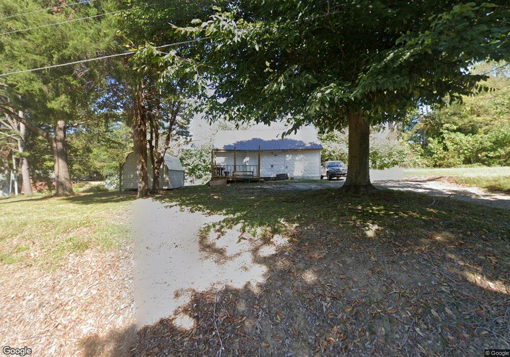
This home is located at 405 W Polk St, Troy, TN 38260 and is currently estimated at $62,077, approximately $92 per square foot. 405 W Polk St is a home located in Obion County.
Ownership History
Date
Name
Owned For
Owner Type
Purchase Details
Closed on
Jun 23, 2023
Sold by
Andrews Betty L and Eggleston Helen
Bought by
Borne Charles Wesley
Current Estimated Value
Purchase Details
Closed on
Dec 1, 2020
Sold by
Andrews Betty L
Bought by
Andrews Betty L and Tatum Gail
Purchase Details
Closed on
May 14, 2004
Sold by
Grover Bradshaw
Bought by
Anderson Betty L
Purchase Details
Closed on
Jan 1, 1955
Bought by
Bradshaw Grover and Bradshaw Louise
Create a Home Valuation Report for This Property
The Home Valuation Report is an in-depth analysis detailing your home's value as well as a comparison with similar homes in the area
Home Values in the Area
Average Home Value in this Area
Purchase History
| Date | Buyer | Sale Price | Title Company |
|---|---|---|---|
| Borne Charles Wesley | $14,000 | None Listed On Document | |
| Borne Charles Wesley | $14,000 | None Listed On Document | |
| Andrews Betty L | -- | None Available | |
| Anderson Betty L | $17,000 | -- | |
| Bradshaw Grover | -- | -- |
Source: Public Records
Tax History Compared to Growth
Tax History
| Year | Tax Paid | Tax Assessment Tax Assessment Total Assessment is a certain percentage of the fair market value that is determined by local assessors to be the total taxable value of land and additions on the property. | Land | Improvement |
|---|---|---|---|---|
| 2024 | -- | $5,200 | $2,250 | $2,950 |
| 2023 | $134 | $5,200 | $2,250 | $2,950 |
| 2022 | $79 | $4,150 | $2,500 | $1,650 |
| 2021 | $77 | $4,275 | $2,500 | $1,775 |
| 2020 | $81 | $4,275 | $2,500 | $1,775 |
| 2019 | $155 | $4,275 | $2,500 | $1,775 |
| 2018 | $153 | $4,275 | $2,500 | $1,775 |
| 2017 | $155 | $4,175 | $2,500 | $1,675 |
| 2016 | $155 | $4,175 | $2,500 | $1,675 |
| 2015 | $155 | $4,175 | $2,500 | $1,675 |
| 2014 | $155 | $4,175 | $2,500 | $1,675 |
Source: Public Records
Map
Nearby Homes
- 202 N Chestnut St
- 609 Westbrook St
- 207 Main St
- 424 Mary Kay Dr
- 307 N Maple St
- 0 Cc Gurien Dr Unit RRA44568
- 0 Campground Rd Unit 241239
- 121 Easley St Unit 125 Easley
- 1202 Hayes St
- 920 S Mary Jane St
- 138 Virginia Dr
- 129 Virginia Dr
- 608 Homestead Dr
- 614 Homestead Dr
- 622 Homestead Dr
- 713 Homestead Dr
- 533 Homestead Dr
- 525 Homestead Dr
- 523 Homestead Dr
- 619 Homestead Dr
- 404 W Harper St
- 408 W Polk St
- 416 W Polk St
- 416 W Polk St
- 420 W Harper St
- 424 W Polk St
- 127 S Maple St
- 502 W Harper St
- 306 W Harper St
- 405 W Moffatt St
- 411 W Moffatt St
- 106 N Chestnut St
- 207 S Maple St
- 317 W Moffatt St
- 413 W Harper St
- 413 W Moffatt St
- 323 W Harper St
- 217 S Maple St
- 206 S Chestnut St
- 114 N Chestnut St