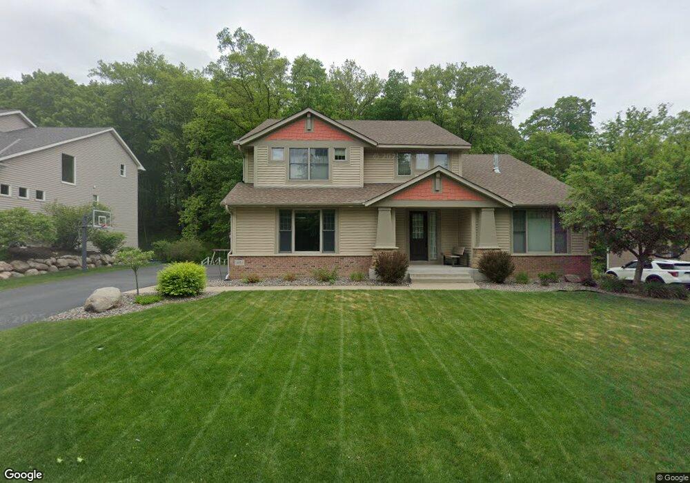
4051 Maple Hurst Dr S Rockford, MN 55373
Estimated Value: $552,275 - $647,000
4
Beds
3
Baths
3,008
Sq Ft
$203/Sq Ft
Est. Value
About This Home
This home is located at 4051 Maple Hurst Dr S, Rockford, MN 55373 and is currently estimated at $611,819, approximately $203 per square foot. 4051 Maple Hurst Dr S is a home located in Wright County with nearby schools including Rockford Elementary Arts Magnet School, Rockford Middle School - Center for Environmental Studies, and Rockford High School.
Ownership History
Date
Name
Owned For
Owner Type
Purchase Details
Closed on
May 30, 2012
Sold by
Thompson Denise A and Thompson Kevin G
Bought by
Wilts Craig and Wilts Bonnie
Current Estimated Value
Purchase Details
Closed on
Aug 29, 2006
Sold by
U S Home Corp
Bought by
Thompson Kevin G and Thompson Denise A
Purchase Details
Closed on
Aug 18, 2006
Sold by
U S Home Corp
Bought by
Thompson Kevin G and Thompson Denise A
Purchase Details
Closed on
Sep 9, 2005
Sold by
Darrel A Farr Development Corp
Bought by
U S Home Corp
Create a Home Valuation Report for This Property
The Home Valuation Report is an in-depth analysis detailing your home's value as well as a comparison with similar homes in the area
Home Values in the Area
Average Home Value in this Area
Purchase History
| Date | Buyer | Sale Price | Title Company |
|---|---|---|---|
| Wilts Craig | $305,000 | -- | |
| Thompson Kevin G | $460,000 | -- | |
| Thompson Kevin G | $460,000 | -- | |
| U S Home Corp | $2,860,000 | -- |
Source: Public Records
Tax History Compared to Growth
Tax History
| Year | Tax Paid | Tax Assessment Tax Assessment Total Assessment is a certain percentage of the fair market value that is determined by local assessors to be the total taxable value of land and additions on the property. | Land | Improvement |
|---|---|---|---|---|
| 2025 | $6,258 | $532,000 | $90,000 | $442,000 |
| 2024 | $6,046 | $530,300 | $90,000 | $440,300 |
| 2023 | $6,036 | $529,700 | $90,000 | $439,700 |
| 2022 | $6,104 | $477,400 | $85,000 | $392,400 |
| 2021 | $6,356 | $428,100 | $70,000 | $358,100 |
| 2020 | $6,598 | $435,900 | $70,000 | $365,900 |
| 2019 | $6,652 | $424,400 | $0 | $0 |
| 2018 | $5,664 | $412,600 | $0 | $0 |
| 2017 | $5,328 | $376,700 | $0 | $0 |
| 2016 | $5,184 | $0 | $0 | $0 |
| 2015 | $5,106 | $0 | $0 | $0 |
| 2014 | -- | $0 | $0 | $0 |
Source: Public Records
Map
Nearby Homes
- 4040 Maple Hurst Dr S
- 4231 Maple Hurst Dr N
- 4090 Maple Hurst Dr S
- XXX Jansen Ave SE
- 7021 Meadow Ct
- 6761 Maple Dr
- 6630 Maple Dr
- 8130 Ravenrock Rd
- 8041 Prairie Trail
- 8530 Fir St
- 7040 Winfield Rd
- 3439 Hall Ave SE
- 6101 Boulder Ridge Dr
- 8098 26th St SE
- 8833 Walnut Place
- 8800 86th Ave N
- XX Hamlin Ave SE
- 8907 Foust Ln
- 5523 Basswood Cir
- 7175 Sterling Dr
- 4051 Maple Hurst Dr S
- 4051 4051 Maple Hurst-Drive-s
- 4061 Maple Hurst Dr S
- 4041 Maple Hurst Dr S
- 4061 4061 Maple Hurst-Drive-s
- 4061 4061 Maple Hurst Dr S
- 4031 Maple Hurst Dr S
- 4071 Maple Hurst Dr S
- 4050 Maple Hurst Dr S
- 4050 4050 Maple Hurst Dr S
- 4060 Maple Hurst Dr S
- 4071 4071 Maple Hurst Dr S
- 4250 Maple Hurst Dr S
- 4070 Maple Hurst Dr S
- 4070 4070 Maple Hurst Dr S
- 4070 4070 Maple Hurst-Drive-s
- XXX Shadow Ridge
- 4081 Maple Hurst Dr S
- 2006 Little Creek Cir
- 4030 Maple Hurst Dr S