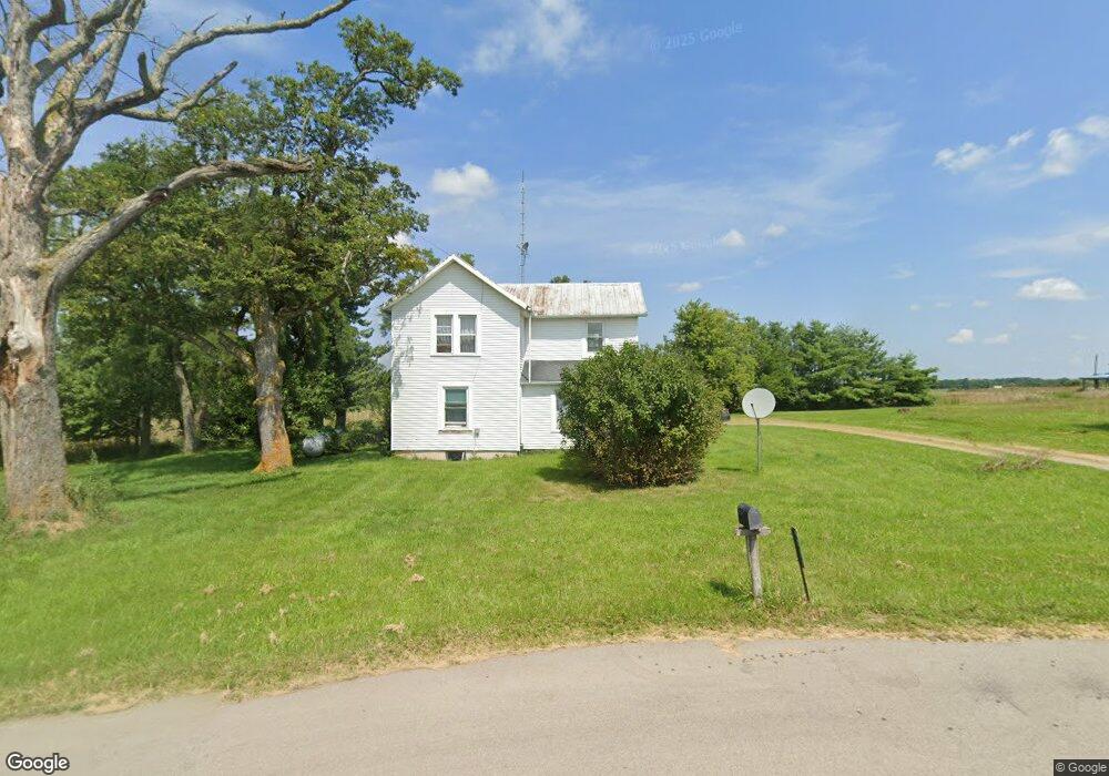
4057 State Route 67 Kenton, OH 43326
Estimated Value: $203,000 - $1,578,464
3
Beds
1
Bath
1,536
Sq Ft
$580/Sq Ft
Est. Value
About This Home
This home is located at 4057 State Route 67, Kenton, OH 43326 and is currently estimated at $890,732, approximately $579 per square foot. 4057 State Route 67 is a home located in Hardin County with nearby schools including Upper Scioto Valley Elementary School, Upper Scioto Valley Middle School, and Upper Scioto Valley High School.
Ownership History
Date
Name
Owned For
Owner Type
Purchase Details
Closed on
Jul 1, 2020
Sold by
G & L Properties Llc
Bought by
Clymer Larry R and Clymer Brenda L
Current Estimated Value
Purchase Details
Closed on
Dec 21, 1999
Bought by
G & L Properties Llc
Purchase Details
Closed on
Aug 6, 1996
Bought by
Grener Barbara L
Create a Home Valuation Report for This Property
The Home Valuation Report is an in-depth analysis detailing your home's value as well as a comparison with similar homes in the area
Home Values in the Area
Average Home Value in this Area
Purchase History
| Date | Buyer | Sale Price | Title Company |
|---|---|---|---|
| Clymer Larry R | -- | None Available | |
| G & L Properties Llc | $210,000 | -- | |
| Grener Barbara L | -- | -- |
Source: Public Records
Tax History Compared to Growth
Tax History
| Year | Tax Paid | Tax Assessment Tax Assessment Total Assessment is a certain percentage of the fair market value that is determined by local assessors to be the total taxable value of land and additions on the property. | Land | Improvement |
|---|---|---|---|---|
| 2024 | $2,989 | $72,970 | $33,830 | $39,140 |
| 2023 | $2,989 | $72,970 | $33,830 | $39,140 |
| 2022 | $4,133 | $96,630 | $64,270 | $32,360 |
| 2021 | $4,354 | $96,630 | $64,270 | $32,360 |
| 2020 | $4,411 | $96,630 | $64,270 | $32,360 |
| 2019 | $2,610 | $59,580 | $31,920 | $27,660 |
| 2018 | $2,596 | $59,580 | $31,920 | $27,660 |
| 2017 | $4,725 | $59,580 | $31,920 | $27,660 |
| 2016 | $7,002 | $192,910 | $171,610 | $21,300 |
| 2015 | $6,885 | $193,190 | $171,610 | $21,580 |
| 2014 | $6,817 | $186,640 | $170,680 | $15,960 |
| 2013 | $3,408 | $84,290 | $67,770 | $16,520 |
Source: Public Records
Map
Nearby Homes
- 16949 Township Road 39
- 16049 Ohio 235 Unit 21
- 0 Ash Ave Unit 1041542
- 16235 Maple Ave
- 11310 Parker Dr
- 17334 Township Road 95
- 16074 Buckeye Ave
- 15527 State Route 235
- 9712 Heron Way
- 9792 Heron Way Unit Lot 52
- 9792 Heron Way Unit Lot 35
- 9722 Heron Way
- 9819 Heron Way
- 9820 Heron Way Unit Lot 32
- 15858 Hickory Ave
- 15410 State Route 235 Unit B
- 15848 Barnes Dr
- 11262 Northlake Dr
- 10998 Township Road 293
- 11065 County Road 293 Unit 13
- 4187 State Route 67
- 4263 Ohio 67
- 4263 Sr
- 4263 State Route 67
- 3923 State Route 67
- 4340 State Route 67
- 3786 State Route 67
- 4494 Sr
- 4494 State Route 67
- 4523 State Route 67
- 4532 State Route 67
- 3632 State Route 67
- 15402 Tr 55
- 15374 Township Road 55
- 16221 Township Road 55
- 15374 Tsp Rd
- 15286 Township Road 55
- 17147 County Road 65
- 15374 Tsp Rd 55