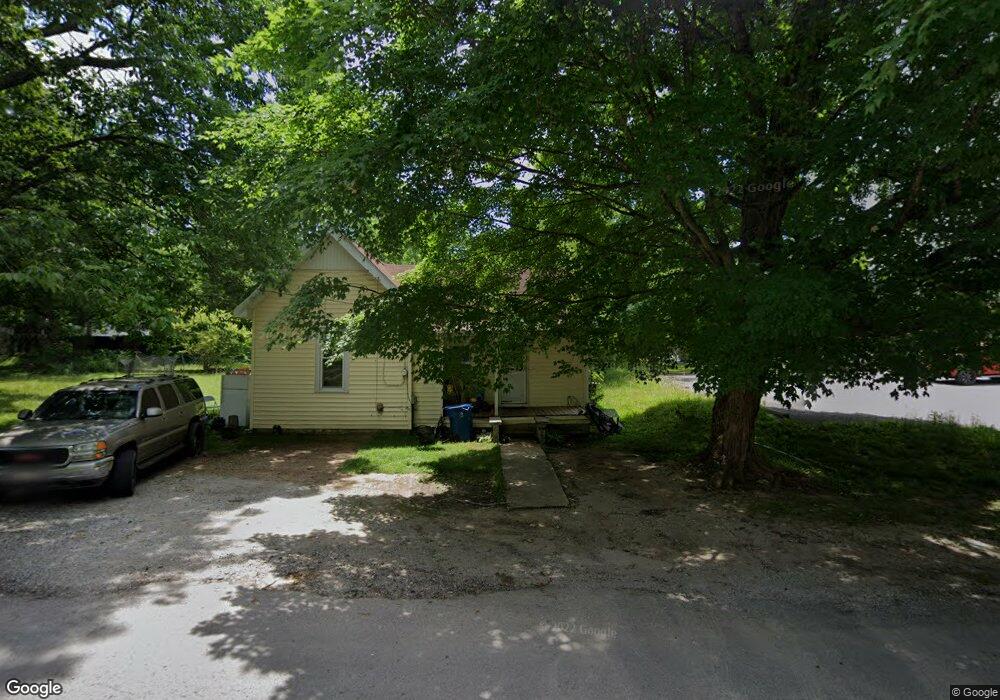
406 E Fort St Manchester, TN 37355
Estimated Value: $83,000 - $182,000
--
Bed
1
Bath
1,138
Sq Ft
$114/Sq Ft
Est. Value
About This Home
This home is located at 406 E Fort St, Manchester, TN 37355 and is currently estimated at $129,773, approximately $114 per square foot. 406 E Fort St is a home located in Coffee County with nearby schools including Westwood Middle School and Temple Baptist Christian School.
Ownership History
Date
Name
Owned For
Owner Type
Purchase Details
Closed on
May 7, 2018
Sold by
Cavalie Hernando
Bought by
Barrera Rosales Jaime and Ayala Rosales Concepion
Current Estimated Value
Purchase Details
Closed on
Apr 6, 2018
Sold by
House Richard Neal and House Leonard David
Bought by
Cavalie Hernando
Purchase Details
Closed on
Sep 14, 2017
Sold by
Brumfield Sue Uselton
Bought by
House Richard Earl and House Betty Jane
Purchase Details
Closed on
Jan 1, 1985
Bought by
House Richard
Create a Home Valuation Report for This Property
The Home Valuation Report is an in-depth analysis detailing your home's value as well as a comparison with similar homes in the area
Home Values in the Area
Average Home Value in this Area
Purchase History
| Date | Buyer | Sale Price | Title Company |
|---|---|---|---|
| Barrera Rosales Jaime | $35,250 | None Available | |
| Cavalie Hernando | $30,000 | Bell & Alexander Title | |
| House Richard Earl | -- | None Available | |
| House Richard | $7,900 | -- |
Source: Public Records
Tax History Compared to Growth
Tax History
| Year | Tax Paid | Tax Assessment Tax Assessment Total Assessment is a certain percentage of the fair market value that is determined by local assessors to be the total taxable value of land and additions on the property. | Land | Improvement |
|---|---|---|---|---|
| 2024 | $522 | $12,375 | $2,000 | $10,375 |
| 2023 | $522 | $12,375 | $0 | $0 |
| 2022 | $449 | $12,375 | $2,000 | $10,375 |
| 2021 | $538 | $11,750 | $2,000 | $9,750 |
| 2020 | $538 | $11,750 | $2,000 | $9,750 |
| 2019 | $538 | $11,750 | $2,000 | $9,750 |
| 2018 | $538 | $11,750 | $2,000 | $9,750 |
| 2017 | $429 | $8,175 | $2,000 | $6,175 |
| 2016 | $429 | $8,175 | $2,000 | $6,175 |
| 2015 | $429 | $8,175 | $2,000 | $6,175 |
| 2014 | $428 | $8,165 | $0 | $0 |
Source: Public Records
Map
Nearby Homes
- 412 E Harp St
- 400 S Ramsey St
- 434 S Ramsey St
- 709 Mill St
- 612 Maple St
- 902 Mcarthur St
- 608 Oakdale St
- 602 Johnson St
- 605 Johnson St
- 793 Old Bushy Branch Rd
- 207 Glenburg Dr
- 1005 Thoma St
- 515 Mckellar Dr
- 800 Wood St
- 54 Country Cir
- 1292 McMinnville Hwy
- 1203 Woodland Dr
- 711 Lowry St
- 1005 Keylon St
- 69 Laurel View St