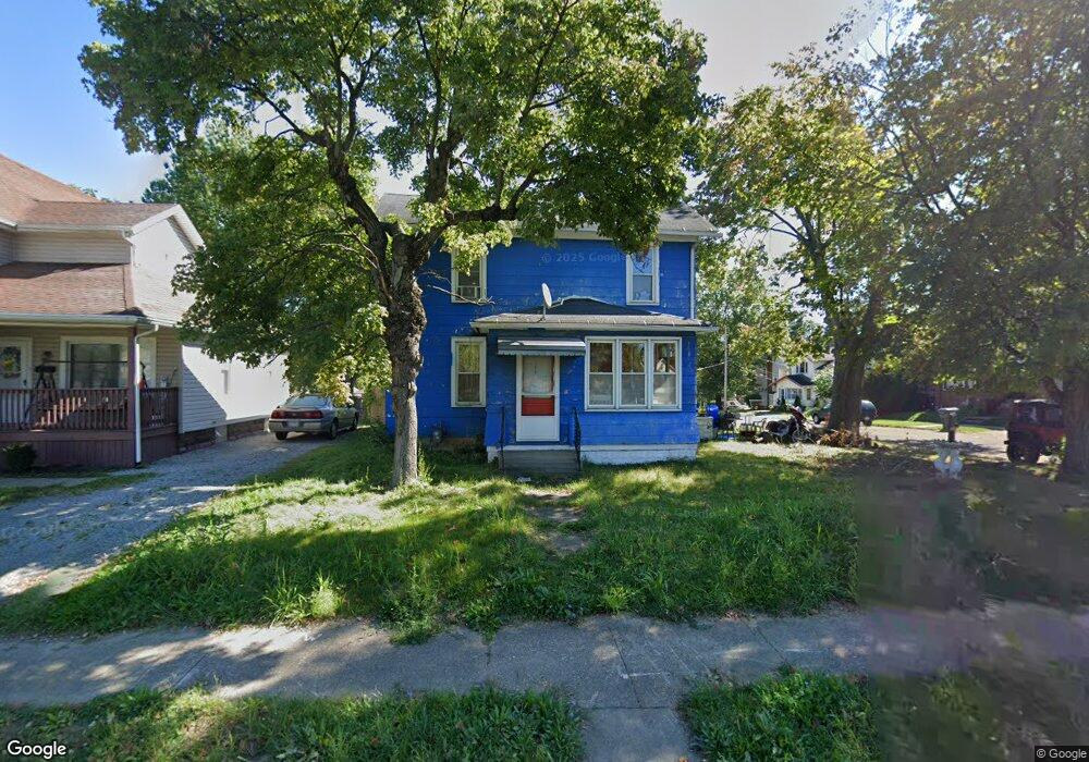
406 Wales Rd NE Massillon, OH 44646
Sippo Heights NeighborhoodEstimated Value: $118,000 - $170,000
3
Beds
2
Baths
1,552
Sq Ft
$87/Sq Ft
Est. Value
About This Home
This home is located at 406 Wales Rd NE, Massillon, OH 44646 and is currently estimated at $134,684, approximately $86 per square foot. 406 Wales Rd NE is a home located in Stark County with nearby schools including Massillon Intermediate School, Massillon Junior High School, and Washington High School.
Ownership History
Date
Name
Owned For
Owner Type
Purchase Details
Closed on
Jul 30, 1997
Sold by
Hornbrook James R
Bought by
Carpenter John C and Gamery Jonica
Current Estimated Value
Home Financials for this Owner
Home Financials are based on the most recent Mortgage that was taken out on this home.
Original Mortgage
$41,325
Outstanding Balance
$6,287
Interest Rate
7.71%
Mortgage Type
New Conventional
Estimated Equity
$128,397
Purchase Details
Closed on
Nov 15, 1990
Create a Home Valuation Report for This Property
The Home Valuation Report is an in-depth analysis detailing your home's value as well as a comparison with similar homes in the area
Home Values in the Area
Average Home Value in this Area
Purchase History
| Date | Buyer | Sale Price | Title Company |
|---|---|---|---|
| Carpenter John C | $43,500 | -- | |
| -- | $24,000 | -- |
Source: Public Records
Mortgage History
| Date | Status | Borrower | Loan Amount |
|---|---|---|---|
| Open | Carpenter John C | $41,325 |
Source: Public Records
Tax History Compared to Growth
Tax History
| Year | Tax Paid | Tax Assessment Tax Assessment Total Assessment is a certain percentage of the fair market value that is determined by local assessors to be the total taxable value of land and additions on the property. | Land | Improvement |
|---|---|---|---|---|
| 2025 | -- | $22,230 | $7,950 | $14,280 |
| 2024 | -- | $29,410 | $7,950 | $21,460 |
| 2023 | $1,821 | $28,110 | $8,860 | $19,250 |
| 2022 | $1,825 | $28,110 | $8,860 | $19,250 |
| 2021 | $1,849 | $28,110 | $8,860 | $19,250 |
| 2020 | $1,307 | $22,960 | $7,280 | $15,680 |
| 2019 | $1,968 | $22,960 | $7,280 | $15,680 |
| 2018 | $1,611 | $22,960 | $7,280 | $15,680 |
| 2017 | $1,543 | $20,480 | $6,160 | $14,320 |
| 2016 | $1,578 | $19,640 | $6,160 | $13,480 |
| 2015 | $1,179 | $19,640 | $6,160 | $13,480 |
| 2014 | $1,204 | $19,390 | $6,090 | $13,300 |
| 2013 | $606 | $19,390 | $6,090 | $13,300 |
Source: Public Records
Map
Nearby Homes
- 1032 Andrew Ave NE
- 817 Wales Rd NE
- 1234 Tremont Ave SE
- 832 Wellman Ave SE
- 1720 Lincoln Way E
- 845 16th St NE
- 727 Franklin Rd NE
- 433 7th St NE
- 528 Lincoln Way E
- 514 Chestnut Ave NE
- 46 5th St SE
- 56 5th St SE
- 931 17th St NE
- 825 Oak Ave SE
- 1034 Irvington Ave NE
- 727 Amherst Rd NE
- 322 3rd St NE
- 739 Vogel Ave NE
- 843 Sheffield Ave NE
- 611 3rd St NE
- 410 Wales Rd NE
- 1214 Andrew Ave NE
- 414 Wales Rd NE
- 1207 Andrew Ave NE
- 1211 Andrew Ave NE
- 420 Wales Rd NE
- 1219 Rodman Ave NE
- 1215 Andrew Ave NE
- 1215 Rodman Ave NE
- 1221 Andrew Ave NE
- 1222 Andrew Ave NE
- 216 Wales Rd NE
- 225 Lewis Place NE
- 221 Wales Rd NE
- 1229 Rodman Ave NE
- 1206 Rodman Ave NE
- 212 Wales Rd NE
- 1137 Andrew Ave NE
- 217 Wales Rd NE
- 426 Harmon Place NE