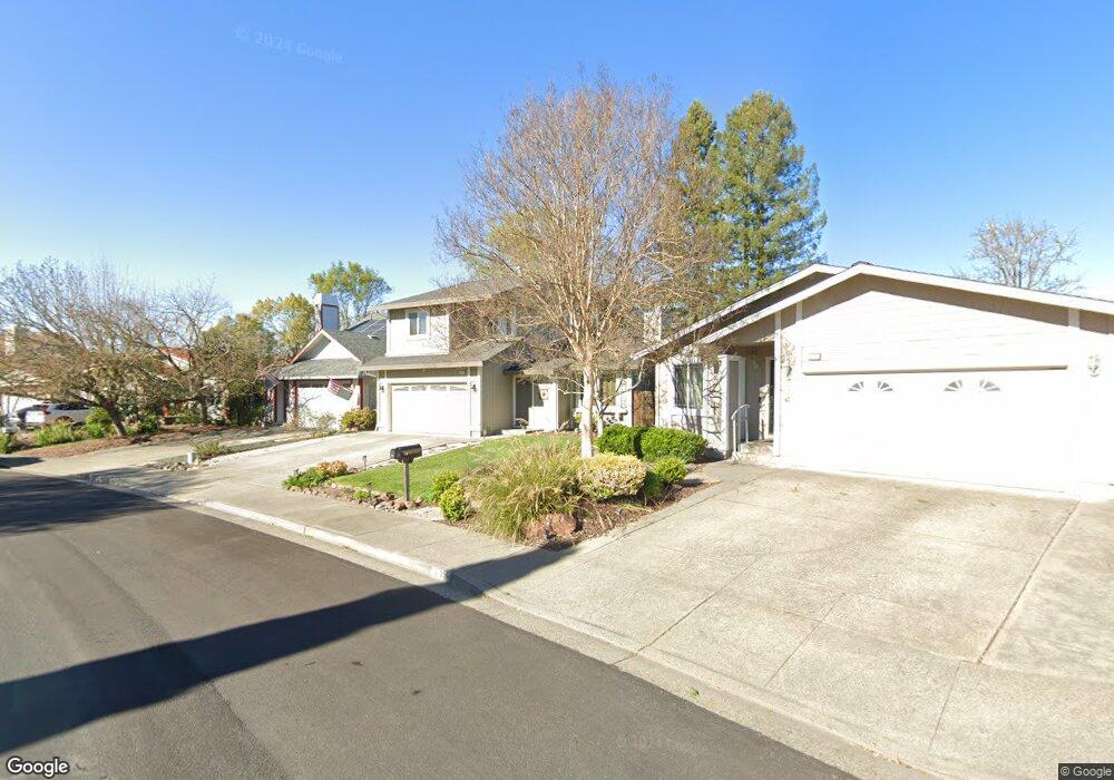
408 Manka Cir Santa Rosa, CA 95403
Estimated Value: $677,000 - $764,000
3
Beds
3
Baths
1,439
Sq Ft
$487/Sq Ft
Est. Value
About This Home
This home is located at 408 Manka Cir, Santa Rosa, CA 95403 and is currently estimated at $700,928, approximately $487 per square foot. 408 Manka Cir is a home located in Sonoma County with nearby schools including Santa Rosa Middle School, Santa Rosa High School, and San Miguel Elementary School.
Ownership History
Date
Name
Owned For
Owner Type
Purchase Details
Closed on
Oct 15, 2020
Sold by
Silva Robin L and Silva Dolores A
Bought by
Silva Robin L and Silva Dolores A
Current Estimated Value
Home Financials for this Owner
Home Financials are based on the most recent Mortgage that was taken out on this home.
Original Mortgage
$185,000
Outstanding Balance
$164,248
Interest Rate
2.8%
Mortgage Type
New Conventional
Estimated Equity
$536,680
Purchase Details
Closed on
May 29, 2018
Sold by
Silva Robin L and Silva Dolores A
Bought by
Silva Robin L and Silva Dolores A
Purchase Details
Closed on
Oct 4, 1994
Sold by
Watson Stuart B and Watson Samuel K
Bought by
Silva Robin L and Silva Dolores A
Home Financials for this Owner
Home Financials are based on the most recent Mortgage that was taken out on this home.
Original Mortgage
$150,300
Interest Rate
8.55%
Create a Home Valuation Report for This Property
The Home Valuation Report is an in-depth analysis detailing your home's value as well as a comparison with similar homes in the area
Home Values in the Area
Average Home Value in this Area
Purchase History
| Date | Buyer | Sale Price | Title Company |
|---|---|---|---|
| Silva Robin L | -- | Servicelink | |
| Silva Robin L | -- | Servicelink | |
| Silva Robin L | -- | None Available | |
| Silva Robin L | $167,000 | Chicago Title Company |
Source: Public Records
Mortgage History
| Date | Status | Borrower | Loan Amount |
|---|---|---|---|
| Open | Silva Robin L | $185,000 | |
| Closed | Silva Robin L | $185,000 | |
| Previous Owner | Silva Robin L | $150,300 |
Source: Public Records
Tax History Compared to Growth
Tax History
| Year | Tax Paid | Tax Assessment Tax Assessment Total Assessment is a certain percentage of the fair market value that is determined by local assessors to be the total taxable value of land and additions on the property. | Land | Improvement |
|---|---|---|---|---|
| 2025 | $4,587 | $280,888 | $126,144 | $154,744 |
| 2024 | $4,587 | $275,381 | $123,671 | $151,710 |
| 2023 | $4,587 | $269,983 | $121,247 | $148,736 |
| 2022 | $4,195 | $264,690 | $118,870 | $145,820 |
| 2021 | $4,044 | $259,501 | $116,540 | $142,961 |
| 2020 | $5,816 | $256,842 | $115,346 | $141,496 |
| 2019 | $5,741 | $251,807 | $113,085 | $138,722 |
| 2018 | $5,557 | $246,870 | $110,868 | $136,002 |
| 2017 | $5,455 | $242,031 | $108,695 | $133,336 |
| 2016 | $5,380 | $237,286 | $106,564 | $130,722 |
| 2015 | $5,254 | $233,723 | $104,964 | $128,759 |
| 2014 | $5,115 | $229,145 | $102,908 | $126,237 |
Source: Public Records
Map
Nearby Homes
- 111 Mark West Commons Cir
- 104 Creek Way
- 5330 Arnica Way
- 5525 Carriage Ln
- 5320 Old Redwood Hwy
- 446 Las Casitas Unit D
- 442 Las Casitas Ct Unit A
- 442 Las Casitas Ct Unit C
- The Camellia Plan at Ava Lane
- The Lilac Plan at Ava Lane
- The Magnolia Plan at Ava Lane
- The Laurel Plan at Ava Lane
- The Marigold Plan at Ava Lane
- 5640 Corbett Cir
- 1447 Wikiup Dr
- 66 Noonan Ranch Cir
- 70 Noonan Ranch Cir
- 5210 Fulton Rd
- 5318 Huckleberry Way
- 5333 Huckleberry Way