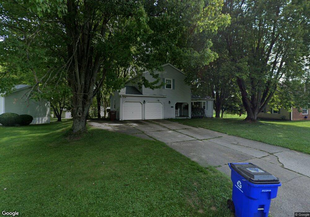
4080 Siefer Dr Rootstown, OH 44272
Estimated Value: $240,693 - $275,000
3
Beds
2
Baths
1,622
Sq Ft
$159/Sq Ft
Est. Value
About This Home
This home is located at 4080 Siefer Dr, Rootstown, OH 44272 and is currently estimated at $257,673, approximately $158 per square foot. 4080 Siefer Dr is a home located in Portage County with nearby schools including Rootstown Middle School - Schnee Building and Rootstown High School.
Ownership History
Date
Name
Owned For
Owner Type
Purchase Details
Closed on
Feb 23, 2022
Sold by
Basinger Gayle L
Bought by
Basinger Gayle L and Basinger Mark R
Current Estimated Value
Home Financials for this Owner
Home Financials are based on the most recent Mortgage that was taken out on this home.
Original Mortgage
$153,550
Outstanding Balance
$141,908
Interest Rate
3.92%
Mortgage Type
New Conventional
Estimated Equity
$115,765
Purchase Details
Closed on
Nov 14, 2001
Sold by
Vanhoose Ronnie and Vanhoose Frances D
Bought by
Flint Gayle L and Basinger Mark R
Home Financials for this Owner
Home Financials are based on the most recent Mortgage that was taken out on this home.
Original Mortgage
$126,800
Interest Rate
6.62%
Purchase Details
Closed on
Jan 1, 1990
Bought by
Vanhoose Ronnie
Create a Home Valuation Report for This Property
The Home Valuation Report is an in-depth analysis detailing your home's value as well as a comparison with similar homes in the area
Purchase History
| Date | Buyer | Sale Price | Title Company |
|---|---|---|---|
| Basinger Gayle L | $125 | Old Republic Title | |
| Flint Gayle L | $133,500 | -- | |
| Vanhoose Ronnie | -- | -- |
Source: Public Records
Mortgage History
| Date | Status | Borrower | Loan Amount |
|---|---|---|---|
| Open | Basinger Gayle L | $153,550 | |
| Previous Owner | Flint Gayle L | $126,800 |
Source: Public Records
Tax History
| Year | Tax Paid | Tax Assessment Tax Assessment Total Assessment is a certain percentage of the fair market value that is determined by local assessors to be the total taxable value of land and additions on the property. | Land | Improvement |
|---|---|---|---|---|
| 2025 | $2,895 | $68,820 | $9,770 | $59,050 |
| 2024 | $2,784 | $68,820 | $9,770 | $59,050 |
| 2023 | $2,343 | $51,490 | $9,770 | $41,720 |
| 2022 | $2,315 | $51,490 | $9,770 | $41,720 |
| 2021 | $2,314 | $51,490 | $9,770 | $41,720 |
| 2020 | $2,137 | $45,750 | $9,770 | $35,980 |
| 2019 | $2,146 | $45,750 | $9,770 | $35,980 |
| 2018 | $1,832 | $36,930 | $9,770 | $27,160 |
| 2017 | $1,832 | $36,930 | $9,770 | $27,160 |
| 2016 | $1,798 | $36,930 | $9,770 | $27,160 |
| 2015 | $1,791 | $36,930 | $9,770 | $27,160 |
| 2014 | $1,824 | $36,930 | $9,770 | $27,160 |
| 2013 | $1,812 | $36,930 | $9,770 | $27,160 |
Source: Public Records
Map
Nearby Homes
- 4079 Siefer Dr
- 0 Lynn Rd Unit 5110102
- 3689 Cherry Hill
- 3701 State Route 44
- V/L 2 Lynn Rd
- V/L Lynn Rd
- 4415 Farmette Dr
- 4200 Hattrick Rd
- sub lot Lane Ave
- 0 Tallmadge Rd Unit 5189301
- 0 Tallmadge Rd Unit 5189314
- 4556 Rootstown Rd
- 4140 Sandy Lake Rd
- 4058 Bayberry Knoll Ln
- 3637 Old Forge Rd
- 5394 Juniper Ct
- 3021 Hartville Rd
- 3925 Summit Rd
- 2978 Sandy Lake Rd
- 1065 Shadowlawn Dr
Your Personal Tour Guide
Ask me questions while you tour the home.