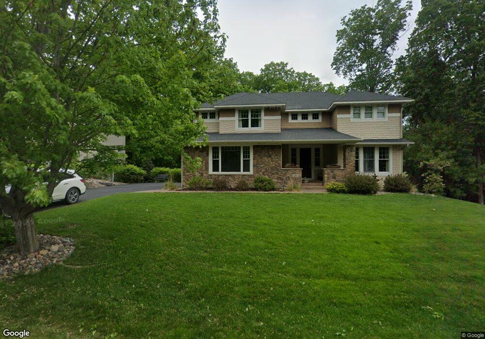
4081 Maple Hurst Dr S Rockford, MN 55373
Estimated Value: $609,000 - $705,463
4
Beds
6
Baths
4,140
Sq Ft
$160/Sq Ft
Est. Value
About This Home
This home is located at 4081 Maple Hurst Dr S, Rockford, MN 55373 and is currently estimated at $661,821, approximately $159 per square foot. 4081 Maple Hurst Dr S is a home located in Wright County with nearby schools including Rockford Elementary Arts Magnet School, Rockford Middle School - Center for Environmental Studies, and Rockford High School.
Ownership History
Date
Name
Owned For
Owner Type
Purchase Details
Closed on
Dec 11, 2020
Sold by
Andrews Benjamin I and Andrews Jessica
Bought by
Schoenborn Sara and Schoenborn Tom
Current Estimated Value
Home Financials for this Owner
Home Financials are based on the most recent Mortgage that was taken out on this home.
Original Mortgage
$341,000
Interest Rate
2.6%
Mortgage Type
New Conventional
Purchase Details
Closed on
Oct 20, 2006
Sold by
U S Home Corp
Bought by
Haag Todd R and Haag Suzanne Jane Cipra
Purchase Details
Closed on
Sep 9, 2005
Sold by
Darrel A Farr Development Corp
Bought by
U S Home Corp
Create a Home Valuation Report for This Property
The Home Valuation Report is an in-depth analysis detailing your home's value as well as a comparison with similar homes in the area
Home Values in the Area
Average Home Value in this Area
Purchase History
| Date | Buyer | Sale Price | Title Company |
|---|---|---|---|
| Schoenborn Sara | $299,000 | All American Title | |
| Haag Todd R | $556,893 | -- | |
| U S Home Corp | $2,860,000 | -- |
Source: Public Records
Mortgage History
| Date | Status | Borrower | Loan Amount |
|---|---|---|---|
| Previous Owner | Schoenborn Sara | $341,000 |
Source: Public Records
Tax History
| Year | Tax Paid | Tax Assessment Tax Assessment Total Assessment is a certain percentage of the fair market value that is determined by local assessors to be the total taxable value of land and additions on the property. | Land | Improvement |
|---|---|---|---|---|
| 2025 | $8,656 | $702,600 | $90,000 | $612,600 |
| 2024 | $8,494 | $699,300 | $90,000 | $609,300 |
| 2023 | $8,290 | $708,500 | $90,000 | $618,500 |
| 2022 | $8,590 | $628,100 | $85,000 | $543,100 |
| 2021 | $8,896 | $584,500 | $70,000 | $514,500 |
| 2020 | $9,246 | $590,800 | $70,000 | $520,800 |
| 2019 | $9,470 | $578,200 | $0 | $0 |
| 2018 | $7,866 | $572,100 | $0 | $0 |
| 2017 | $7,426 | $519,300 | $0 | $0 |
| 2016 | $7,228 | $0 | $0 | $0 |
| 2015 | $7,092 | $0 | $0 | $0 |
| 2014 | -- | $0 | $0 | $0 |
Source: Public Records
Map
Nearby Homes
- TBD Jansen Ave SE
- 6050 Iris Ln
- 6023 Iris Ln
- 8130 Ravenrock Rd
- 6900 Nyle Ct
- TBD Main St
- 6230 Boulder Ridge Dr
- 7010 Guilford Ln
- 5900 Maple St
- TBD Highway 55
- 6830 36th St SE
- 7806 Bridgewater Ct
- 7804 Bridgewater Ct
- 7865 Kettering Creek Ct
- 7803 Bridgewater Ct
- 7872 Willowbrook Ct
- 7801 Bridgewater Ct
- 2169 Ibson Ave SE
- 7870 Willowbrook Ct
- 4851 Maple St
- 4071 Maple Hurst Dr S
- 4071 4071 Maple Hurst Dr S
- 4111 Maple Hurst Dr S
- 4111 4111 Maple Hurst-Drive-s
- 4061 Maple Hurst Dr S
- 4061 4061 Maple Hurst-Drive-s
- 4061 4061 Maple Hurst Dr S
- 4080 Maple Hurst Dr S
- 4080 4080 Maple Hurst Dr S
- 4100 Maple Hurst Dr S
- 4070 Maple Hurst Dr S
- 4070 4070 Maple Hurst Dr S
- 4070 4070 Maple Hurst-Drive-s
- 4110 Maple Hurst Dr S
- 4121 Maple Hurst Dr S
- 4121 4121 Maple Hurst Dr S
- 4251 Maple Hurst Dr S
- 4051 Maple Hurst Dr S
- 4051 Maple Hurst Dr S
- 4051 4051 Maple Hurst-Drive-s
Your Personal Tour Guide
Ask me questions while you tour the home.