Estimated Value: $150,000 - $167,000
3
Beds
1
Bath
1,098
Sq Ft
$147/Sq Ft
Est. Value
About This Home
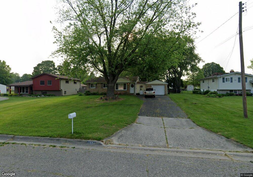
This home is located at 4082 Sam Snead Dr, Flint, MI 48506 and is currently estimated at $161,604, approximately $147 per square foot. 4082 Sam Snead Dr is a home located in Genesee County with nearby schools including Weston Elementary School, Kate Dowdall Elementary School, and Leota Fiedler Elementary School.
Ownership History
Date
Name
Owned For
Owner Type
Purchase Details
Closed on
Oct 5, 2010
Sold by
Secretary Of Housing & Urban Development
Bought by
Stockton Robert
Current Estimated Value
Purchase Details
Closed on
May 5, 2010
Sold by
Guardian Mortgage Company Inc
Bought by
Secretary Of Housing & Urban Development
Purchase Details
Closed on
Nov 4, 2009
Sold by
Kononchuk Kari L and Bailey Steven F
Bought by
Guardian Mortgage Company Inc
Purchase Details
Closed on
Dec 17, 2002
Sold by
Ashley Robert B and Ashley Shelly D
Bought by
Kononchuk Kari L and Bailey Steven F
Create a Home Valuation Report for This Property
The Home Valuation Report is an in-depth analysis detailing your home's value as well as a comparison with similar homes in the area
Home Values in the Area
Average Home Value in this Area
Purchase History
| Date | Buyer | Sale Price | Title Company |
|---|---|---|---|
| Stockton Robert | $38,381 | None Available | |
| Secretary Of Housing & Urban Development | -- | None Available | |
| Guardian Mortgage Company Inc | $110,060 | None Available | |
| Kononchuk Kari L | $118,000 | Metropolitan Title Company |
Source: Public Records
Tax History Compared to Growth
Tax History
| Year | Tax Paid | Tax Assessment Tax Assessment Total Assessment is a certain percentage of the fair market value that is determined by local assessors to be the total taxable value of land and additions on the property. | Land | Improvement |
|---|---|---|---|---|
| 2025 | $2,338 | $75,100 | $0 | $0 |
| 2024 | $438 | $73,400 | $0 | $0 |
| 2023 | $418 | $67,500 | $0 | $0 |
| 2022 | $1,971 | $58,800 | $0 | $0 |
| 2021 | $1,960 | $52,900 | $0 | $0 |
| 2020 | $383 | $49,300 | $0 | $0 |
| 2019 | $376 | $45,900 | $0 | $0 |
| 2018 | $1,867 | $40,800 | $0 | $0 |
| 2017 | $1,263 | $39,200 | $0 | $0 |
| 2016 | $1,235 | $37,100 | $0 | $0 |
| 2015 | $1,040 | $34,400 | $0 | $0 |
| 2014 | $347 | $30,900 | $0 | $0 |
| 2012 | -- | $30,100 | $30,100 | $0 |
Source: Public Records
Map
Nearby Homes
- 4318 Tommy Armour Dr
- 3413 Blue Lake Dr
- 3414 N Genesee Rd
- 4141 Hidden View Dr
- 5142 Berneda Dr
- 3294 Comer Dr
- 4055 Mitchell Dr
- 5111 Paro Dr
- 4237 Sugar Maple Run Unit 8
- 3301 S Kearsley Blvd
- 4231 Sugar Maple Run Unit 7
- 4455 N Genesee Rd
- 4225 Sugar Maple Run Unit 6
- 4213 Sugar Maple Run Unit 4
- 4419 Maple Leaf Trail
- 4413 Maple Leaf Trail
- 4207 Sugar Maple Run Unit 3
- 4444 Maple Leaf Trail
- 5068 Roberts Dr
- 4438 Maple Leaf Trail
- 4070 Sam Snead Dr
- 4060 Sam Snead Dr
- 4090 Sam Snead Dr
- 4071 Sam Snead Dr
- 4083 Sam Snead Dr
- 4065 Sam Snead Dr
- 4044 Sam Snead Dr
- 4054 Sam Snead Dr
- 4075 Ben Hogan Dr
- 4057 Sam Snead Dr
- 4067 Ben Hogan Dr
- 4083 Ben Hogan Dr
- 4091 Ben Hogan Dr
- 4103 Sam Snead Dr
- 4330 Tommy Armour Dr
- 4051 Sam Snead Dr
- 4036 Sam Snead Dr
- 4059 Ben Hogan Dr
- 4099 Ben Hogan Dr
- 0 Sugar Maple Farms Unit 58050026250