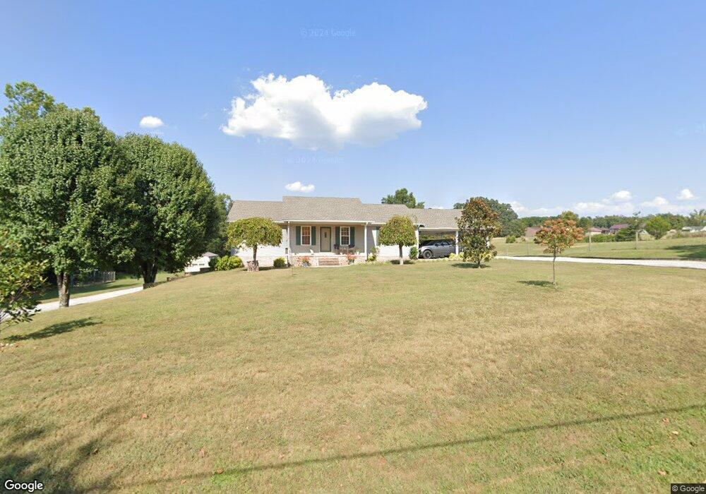
4087 Pollard Rd Walling, TN 38587
Estimated Value: $230,463 - $342,000
Studio
2
Baths
1,600
Sq Ft
$173/Sq Ft
Est. Value
About This Home
This home is located at 4087 Pollard Rd, Walling, TN 38587 and is currently estimated at $277,366, approximately $173 per square foot. 4087 Pollard Rd is a home located in White County with nearby schools including Central View Elementary School, White County Middle School, and White County High School.
Ownership History
Date
Name
Owned For
Owner Type
Purchase Details
Closed on
Jul 27, 2020
Sold by
Johnson Ben Allen and Lee Barry
Bought by
Johnson Barry Lee and Johnson Betty Elaine
Current Estimated Value
Purchase Details
Closed on
Nov 24, 2004
Sold by
Lee Johnson Barry
Bought by
Elaine Johnson Betty
Purchase Details
Closed on
Sep 30, 1997
Sold by
Johnson Barry L and Johnson Janice
Bought by
Johnson Barry L
Purchase Details
Closed on
Jul 12, 1995
Bought by
Johnson Barry L and Johnson Janice
Purchase Details
Closed on
Nov 1, 1985
Bought by
Johnson Barry and Johnson Janice
Create a Home Valuation Report for This Property
The Home Valuation Report is an in-depth analysis detailing your home's value as well as a comparison with similar homes in the area
Purchase History
| Date | Buyer | Sale Price | Title Company |
|---|---|---|---|
| Johnson Barry Lee | -- | None Available | |
| Elaine Johnson Betty | -- | -- | |
| Johnson Barry L | -- | -- | |
| Johnson Barry L | $3,000 | -- | |
| Johnson Barry | -- | -- |
Source: Public Records
Tax History
| Year | Tax Paid | Tax Assessment Tax Assessment Total Assessment is a certain percentage of the fair market value that is determined by local assessors to be the total taxable value of land and additions on the property. | Land | Improvement |
|---|---|---|---|---|
| 2025 | $860 | $60,975 | $4,000 | $56,975 |
| 2024 | $734 | $35,800 | $2,875 | $32,925 |
| 2023 | $0 | $35,800 | $2,875 | $32,925 |
| 2022 | $734 | $35,800 | $2,875 | $32,925 |
| 2021 | $734 | $35,800 | $2,875 | $32,925 |
| 2020 | $726 | $35,800 | $2,875 | $32,925 |
| 2019 | $656 | $32,000 | $2,500 | $29,500 |
| 2018 | $656 | $32,000 | $2,500 | $29,500 |
| 2017 | $656 | $32,000 | $2,500 | $29,500 |
| 2016 | $656 | $32,000 | $2,500 | $29,500 |
| 2015 | $592 | $32,000 | $2,500 | $29,500 |
| 2014 | -- | $32,000 | $2,500 | $29,500 |
| 2013 | -- | $31,625 | $2,500 | $29,125 |
Source: Public Records
Map
Nearby Homes
- 14305 Old Kentucky Rd
- 14133 Old Kentucky Rd
- 00 Pollard Cemetery Rd
- 0 Pollard Cemetery Rd
- 2.28 Acres Pates Ford Rd
- 13593 Old Kentucky Rd
- 13723 Old Kentucky Rd
- 14630 Old Kentucky Rd
- 2530 Pollard Rd
- 13400 Old Kentucky Rd
- 265 N Center Point Acres
- 0 Center Point Acres N Unit 1322803
- 0 Center Point Acres N Unit 240744
- 0 Center Point Acres N Unit RTC3050083
- 1295 Darkey Springs Rd
- 3297 Three Island Rd
- 620 Roberts Cemetery Rd
- 00 Roberts Cemetery Rd
- 151 AC. Roberts Cemetery Rd
- 2.21 AC Pates Ford Rd
- 4009 Pollard Rd
- 4186 Pollard Rd
- 4214 Pollard Rd
- 1506 Three Island Rd
- 3943 Pollard Rd
- 1543 3 Island Rd
- 1736 Three Island Rd
- 1505 Three Island Rd
- 1840 Betterton Rd
- 1406 Three Island Rd
- 3899 Pollard Rd
- 3865 Pollard Rd
- 1817 3 Island Rd
- 1755 Betterton Rd
- 3821 Pollard Rd
- 1728 Betterton Rd
- 1330 Three Island Rd
- 1733 Betterton Rd
- 3789 Pollard Rd
- 1667 Betterton Rd
Your Personal Tour Guide
Ask me questions while you tour the home.