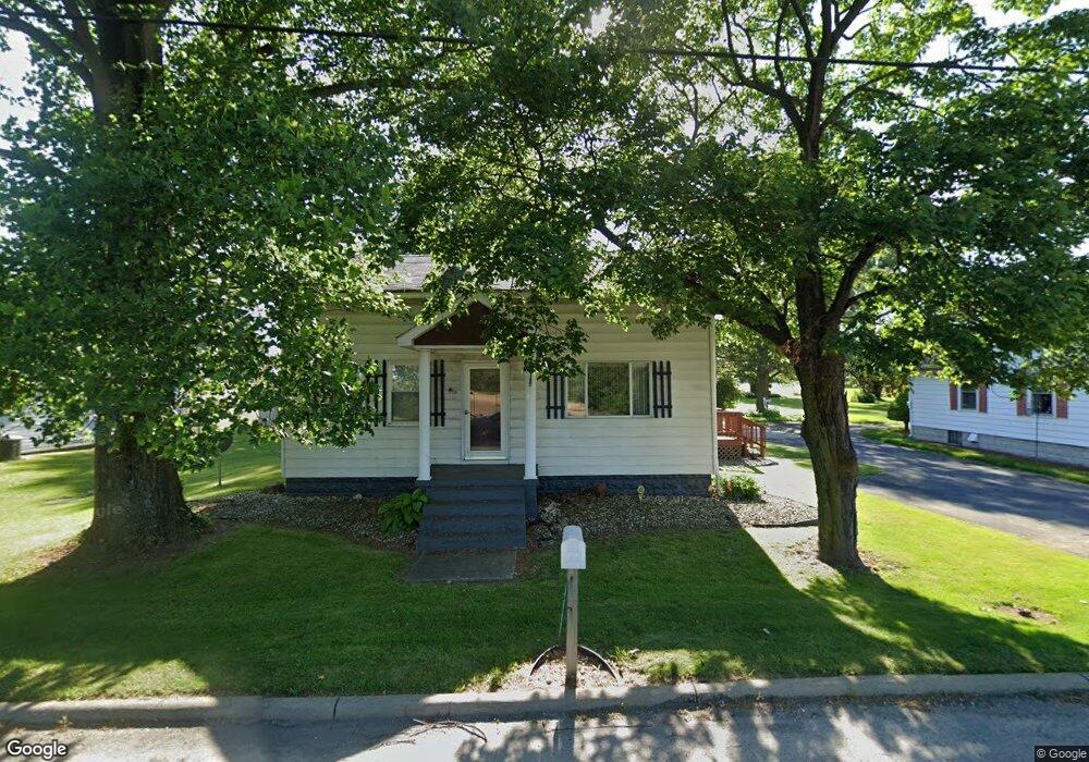
4087 State Route 61 Plymouth, OH 44865
Estimated Value: $127,260 - $174,000
4
Beds
2
Baths
1,375
Sq Ft
$112/Sq Ft
Est. Value
About This Home
This home is located at 4087 State Route 61, Plymouth, OH 44865 and is currently estimated at $153,815, approximately $111 per square foot. 4087 State Route 61 is a home located in Huron County with nearby schools including Willard Middle/High School, Celeryville Christian School, and St Francis Xavier School.
Ownership History
Date
Name
Owned For
Owner Type
Purchase Details
Closed on
Mar 8, 2005
Bought by
Dalton Kelly
Current Estimated Value
Purchase Details
Closed on
Jul 7, 2000
Sold by
Hicks Keith
Bought by
Bivens Richard A and Bivens Betty
Purchase Details
Closed on
Feb 10, 1995
Sold by
Sherman Nancy M
Bought by
Hicks Keith and Hicks Tonya
Home Financials for this Owner
Home Financials are based on the most recent Mortgage that was taken out on this home.
Original Mortgage
$36,500
Interest Rate
9.21%
Mortgage Type
New Conventional
Create a Home Valuation Report for This Property
The Home Valuation Report is an in-depth analysis detailing your home's value as well as a comparison with similar homes in the area
Home Values in the Area
Average Home Value in this Area
Purchase History
| Date | Buyer | Sale Price | Title Company |
|---|---|---|---|
| Dalton Kelly | $90,000 | -- | |
| Bivens Richard A | $52,000 | -- | |
| Hicks Keith | $38,500 | -- | |
| Hicks Keith | $38,500 | -- |
Source: Public Records
Mortgage History
| Date | Status | Borrower | Loan Amount |
|---|---|---|---|
| Previous Owner | Hicks Keith | $36,500 |
Source: Public Records
Tax History Compared to Growth
Tax History
| Year | Tax Paid | Tax Assessment Tax Assessment Total Assessment is a certain percentage of the fair market value that is determined by local assessors to be the total taxable value of land and additions on the property. | Land | Improvement |
|---|---|---|---|---|
| 2024 | $873 | $24,680 | $3,680 | $21,000 |
| 2023 | $873 | $20,340 | $2,310 | $18,030 |
| 2022 | $798 | $20,340 | $2,310 | $18,030 |
| 2021 | $798 | $20,340 | $2,310 | $18,030 |
| 2020 | $770 | $19,040 | $2,310 | $16,730 |
| 2019 | $789 | $19,040 | $2,310 | $16,730 |
| 2018 | $788 | $19,040 | $2,310 | $16,730 |
| 2017 | $706 | $17,530 | $2,310 | $15,220 |
| 2016 | $701 | $17,530 | $2,310 | $15,220 |
| 2015 | $694 | $17,530 | $2,310 | $15,220 |
| 2014 | $673 | $16,730 | $2,310 | $14,420 |
| 2013 | $644 | $16,730 | $2,310 | $14,420 |
Source: Public Records
Map
Nearby Homes
- 4259 State Route 598
- 4265 State Route 61
- 2865 Neal Zick Rd
- 1981 Skinner Rd
- 4038 Mills Rd
- 1780 U S 224
- 818 Theo Moll Dr
- 1424 Conwell Ave
- 29 Wedgewood Dr
- 1531 S Conwell Ave
- 66 Hillcrest Dr
- 2 Plum Creek Meadows
- 396 W Broadway St
- 1653 Boughtonville Rd
- 266 W Broadway St
- 32 Brooks Ct
- 534 Spangler St
- 528 Maplewood St
- 4095 S State Route 61 S
- 4079 State Route 61 S
- 2702 Ohio 598
- 4096 State Route 61
- 4121 State Route 61
- 2691 St Rt 224
- 4127 State Route 61
- 4125 State Route 61
- 4143 State Route 61
- 4143 State Route 61
- 5397 U S 224
- 4455 U S 224
- 4142 Ohio 598
- 4152 State Route 61
- 4528 West St
- 4504 West St
- 4756 West St
- 5476 West St
- 5046 West St
- 4996 West St