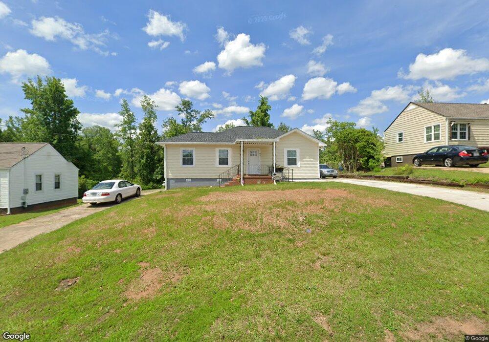
41 4th St Newnan, GA 30263
Estimated Value: $35,000 - $206,000
3
Beds
1
Bath
1,464
Sq Ft
$108/Sq Ft
Est. Value
About This Home
This home is located at 41 4th St, Newnan, GA 30263 and is currently estimated at $157,588, approximately $107 per square foot. 41 4th St is a home located in Coweta County with nearby schools including Atkinson Elementary School, Smokey Road Middle School, and Newnan High School.
Ownership History
Date
Name
Owned For
Owner Type
Purchase Details
Closed on
Nov 19, 2024
Sold by
Johnson Betty Ruth
Bought by
Monitor Holdings Llc
Current Estimated Value
Home Financials for this Owner
Home Financials are based on the most recent Mortgage that was taken out on this home.
Original Mortgage
$165,000
Outstanding Balance
$14,165
Interest Rate
6.54%
Mortgage Type
New Conventional
Estimated Equity
$143,423
Purchase Details
Closed on
Apr 16, 2007
Sold by
Brown Nan
Bought by
Morris Rick
Purchase Details
Closed on
Aug 26, 2003
Sold by
Shoemake Horace A
Bought by
Brown Nan
Purchase Details
Closed on
Jan 7, 1999
Sold by
Johnson Edward O and Johnson B
Bought by
Johnson Betty Ruth
Purchase Details
Closed on
Oct 14, 1977
Bought by
Johnson Edward O and Johnson B
Create a Home Valuation Report for This Property
The Home Valuation Report is an in-depth analysis detailing your home's value as well as a comparison with similar homes in the area
Home Values in the Area
Average Home Value in this Area
Purchase History
| Date | Buyer | Sale Price | Title Company |
|---|---|---|---|
| Monitor Holdings Llc | $32,500 | -- | |
| Monitor Holdings Llc | $32,500 | -- | |
| Morris Rick | $15,000 | -- | |
| Brown Nan | -- | -- | |
| Johnson Betty Ruth | -- | -- | |
| Johnson Edward O | $23,500 | -- |
Source: Public Records
Mortgage History
| Date | Status | Borrower | Loan Amount |
|---|---|---|---|
| Open | Monitor Holdings Llc | $165,000 | |
| Closed | Monitor Holdings Llc | $99,000 |
Source: Public Records
Tax History Compared to Growth
Tax History
| Year | Tax Paid | Tax Assessment Tax Assessment Total Assessment is a certain percentage of the fair market value that is determined by local assessors to be the total taxable value of land and additions on the property. | Land | Improvement |
|---|---|---|---|---|
| 2025 | $2,084 | $86,764 | $9,520 | $77,244 |
| 2024 | $1,290 | $56,476 | $9,520 | $46,956 |
| 2023 | $1,290 | $57,132 | $9,520 | $47,612 |
| 2022 | $1,166 | $47,912 | $9,520 | $38,392 |
| 2021 | $1,074 | $39,943 | $9,520 | $30,423 |
| 2020 | $341 | $39,943 | $9,520 | $30,423 |
| 2019 | $195 | $23,575 | $9,216 | $14,359 |
| 2018 | $198 | $23,575 | $9,216 | $14,359 |
| 2017 | $195 | $23,575 | $9,216 | $14,359 |
| 2016 | $162 | $20,541 | $5,530 | $15,012 |
| 2015 | $162 | $20,541 | $5,530 | $15,012 |
| 2014 | $84 | $13,362 | $5,530 | $7,832 |
Source: Public Records
Map
Nearby Homes
- 70 Hollis Heights
- 114 Boone Dr
- 157 Lagrange St
- 68 Spring St
- 71 Spring St
- 26 Boone Dr
- 97 W Washington St
- 33 Ray St
- 131 Woodbine Cir
- 140 Catalina Ct
- 0 N Highway 29 Unit 20115352
- 7 N Annie St
- 16 Hamilton Bohannon Dr
- 218 Arlington Ct
- 20 Salbide Ave
- 138 Greenville St
- 51 Robinson St
- 18 Rutherford Dr Unit LOT 28
- 61 Clark St
- 100 Lovelace St