
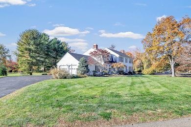
41 Butternut Ln Southport, CT 06890
Highlights
- Beach Access
- Colonial Architecture
- Attic
- Dwight Elementary School Rated A
- Deck
- 3 Fireplaces
About This Home
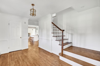
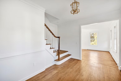
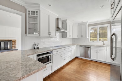
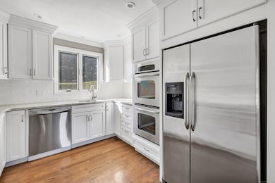
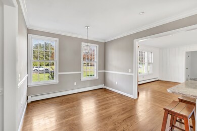
Nestled on a quiet street off Hulls Highway, this newly refreshed Colonial offers the perfect blend of comfort, privacy, and convenience. Located on a peaceful cul-de-sac with minimal traffic, it's an ideal setting for evening walks and bike rides. Perfectly positioned between Fairfield and Westport, you're just minutes from shops, dining, and the Southport train station. Inside, a classic front-to-back living room with a wood-burning fireplace opens to a formal dining room-ideal for gatherings large or small. The updated eat-in kitchen flows seamlessly into the family room, where a second fireplace adds warmth and charm. Step out to an expansive deck perfect for summer BBQs and outdoor dining beneath the trees. Beyond the deck, the level 1.19-acre yard invites play-think soccer games, backyard campouts, or snow forts in winter-all surrounded by nature's calm. A mudroom, half bath, and laundry area connect conveniently to the attached two-car garage. Upstairs, the spacious primary suite offers two walk-in closets and a private bath with a shower. Three additional bedrooms and a full hall bath complete this level. Need more space? The walk-up attic provides ample storage, while the finished walk-out lower level offers flexibility for a playroom, gym, or media room. Experience the best of Southport living-quiet streets, a welcoming setting, and room to truly spread out. Discover the charm, convenience, and connection that make Southport feel like home.
Listing Agent
Coldwell Banker Realty Brokerage Phone: (646) 734-3514 License #RES.0799999 Listed on: 11/03/2025

Co-Listing Agent
Coldwell Banker Realty Brokerage Phone: (646) 734-3514 License #RES.0814506
Home Details
Home Type
- Single Family
Est. Annual Taxes
- $19,662
Year Built
- Built in 1979
Lot Details
- 1.19 Acre Lot
- Sprinkler System
- Property is zoned AA
Home Design
- Colonial Architecture
- Clap Board Siding
Interior Spaces
- 3 Fireplaces
- Mud Room
Kitchen
- Built-In Oven
- Electric Cooktop
- Range Hood
- Microwave
- Dishwasher
Bedrooms and Bathrooms
- 4 Bedrooms
Laundry
- Laundry on main level
- Dryer
- Washer
Attic
- Storage In Attic
- Walkup Attic
Partially Finished Basement
- Walk-Out Basement
- Basement Fills Entire Space Under The House
Parking
- 2 Car Garage
- Parking Deck
- Automatic Garage Door Opener
Outdoor Features
- Beach Access
- Deck
- Outdoor Grill
- Rain Gutters
Location
- Property is near shops
Schools
- Dwight Elementary School
- Roger Ludlowe Middle School
- Fairfield Ludlowe High School
Utilities
- Central Air
- Hot Water Heating System
- Heating System Uses Oil
- Hot Water Circulator
- Fuel Tank Located in Basement
- Cable TV Available
Community Details
- Pets Allowed with Restrictions
Listing and Financial Details
- Assessor Parcel Number 136057
Map
Source: SmartMLS
MLS Number: 24135481
APN: FAIR-000246-000000-000001-C000000
Disclaimer: Certain information contained herein is derived from information provided by parties other than Homes.com. All information provided is deemed reliable, but is not guaranteed to be accurate and should be independently verified.
![]() IDX information is provided exclusively for personal, non-commercial use, and may not be used for any purpose other than to identify prospective properties consumers may be interested in purchasing. Information is deemed reliable but not guaranteed.
IDX information is provided exclusively for personal, non-commercial use, and may not be used for any purpose other than to identify prospective properties consumers may be interested in purchasing. Information is deemed reliable but not guaranteed.
- 1001 Hulls Farm Rd
- 1 Sturges Hwy Unit Lot 1
- 1 Sturges Hwy Unit 2
- 688 Hulls Farm Rd
- 10 Debra Ln
- 125 Old Rd
- 107 Old Rd
- 1 Coastal Ct
- 1135 Mill Hill Rd
- 40 Maple Ave N
- 21 Sturges Commons
- 844 Mill Hill Terrace
- 153 Pease Ave
- 21 Queens Grant Dr
- 476 Mill Hill Terrace
- 6 Bayberry Common
- 220 Lansdowne
- 7 High Gate Rd
- 2 Elmwood Dr Unit 2
- 36 Maple Ave S
- 1110 Mill Hill Terrace
- 95 Taylor Place
- 196 Woodrow Ave
- 20 Southport Woods Dr
- 29 Pease Ave
- 1990 Bronson Rd Unit 6
- 1990 Bronson Rd Unit 8
- 1990 Bronson Rd Unit 2
- 3 George St
- 1480 Post Rd E
- 46 Old Rd
- 111 Mill Hill Rd
- 99 Sturges Hwy
- 504 Harvest Commons Unit 504
- 135 Regents Park
- 120 Merwins Ln
- 25 Pequot Ave
- 55 Cider Mill Ln Unit Cottage
- 35 Rose Hill Rd
- 3 Parsell Ln