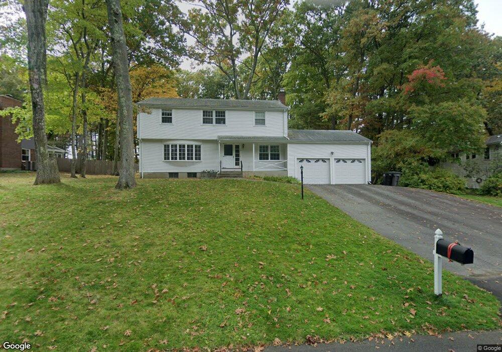
41 Crestwood Dr Framingham, MA 01701
Estimated Value: $811,000 - $899,000
4
Beds
3
Baths
2,084
Sq Ft
$408/Sq Ft
Est. Value
About This Home
This home is located at 41 Crestwood Dr, Framingham, MA 01701 and is currently estimated at $850,701, approximately $408 per square foot. 41 Crestwood Dr is a home located in Middlesex County with nearby schools including Framingham High School, Christa McAuliffe Charter School, and Saint Bridget School.
Ownership History
Date
Name
Owned For
Owner Type
Purchase Details
Closed on
Jul 13, 2010
Sold by
Haberman Tr Wolf and Haberman Berna G
Bought by
Klemme Jayson D
Current Estimated Value
Home Financials for this Owner
Home Financials are based on the most recent Mortgage that was taken out on this home.
Original Mortgage
$328,000
Outstanding Balance
$218,613
Interest Rate
4.78%
Mortgage Type
Purchase Money Mortgage
Estimated Equity
$632,088
Create a Home Valuation Report for This Property
The Home Valuation Report is an in-depth analysis detailing your home's value as well as a comparison with similar homes in the area
Home Values in the Area
Average Home Value in this Area
Purchase History
| Date | Buyer | Sale Price | Title Company |
|---|---|---|---|
| Klemme Jayson D | $410,000 | -- |
Source: Public Records
Mortgage History
| Date | Status | Borrower | Loan Amount |
|---|---|---|---|
| Open | Klemme Jayson D | $328,000 |
Source: Public Records
Tax History Compared to Growth
Tax History
| Year | Tax Paid | Tax Assessment Tax Assessment Total Assessment is a certain percentage of the fair market value that is determined by local assessors to be the total taxable value of land and additions on the property. | Land | Improvement |
|---|---|---|---|---|
| 2025 | $8,009 | $670,800 | $287,400 | $383,400 |
| 2024 | $7,933 | $636,700 | $256,200 | $380,500 |
| 2023 | $7,455 | $569,500 | $228,600 | $340,900 |
| 2022 | $7,086 | $515,700 | $207,800 | $307,900 |
| 2021 | $6,877 | $489,500 | $199,800 | $289,700 |
| 2020 | $6,910 | $461,300 | $181,700 | $279,600 |
| 2019 | $6,849 | $445,300 | $181,700 | $263,600 |
| 2018 | $6,822 | $418,000 | $178,100 | $239,900 |
| 2017 | $6,719 | $402,100 | $172,900 | $229,200 |
| 2016 | $6,743 | $388,000 | $174,500 | $213,500 |
| 2015 | $6,725 | $377,400 | $175,200 | $202,200 |
Source: Public Records
Map
Nearby Homes
- 52 Lohnes Rd
- 17 Lilian Rd
- 33 Highgate Rd
- 18 Auburn Street Extension
- 4 Mclaughlin St Unit 3
- 194 Beacon St
- 145 Beacon St
- 8 Old Conn Path
- Lot 2A Murray Hill Rd
- Lot 3 Murray Hill Rd
- 609 Union Ave Unit 609
- 171 Walnut St
- 111 Higgins Rd
- 29 Prescott St
- 92 Old Connecticut Path
- 144 Old Connecticut Path
- 46 Perry Henderson Dr
- 10 Main St Unit 507
- 1 Skyline Dr
- 693 Concord St
- 43 Crestwood Dr
- 39 Crestwood Dr
- 28 Gilleonard Ln
- 26 Gilleonard Ln
- 45 Crestwood Dr
- 35 Crestwood Dr
- 44 Crestwood Dr
- 42 Crestwood Dr
- 38 Crestwood Dr
- 24 Gilleonard Ln
- 40 Crestwood Dr
- 46 Crestwood Dr
- 24 Gil Leonard Ln
- 22 Gilleonard Ln
- 22 Gilleonard Ln
- 36 Crestwood Dr
- 17 Wyndstone Way
- 164 Lockland Ave
- 33 Crestwood Dr
- 162 Lockland Ave