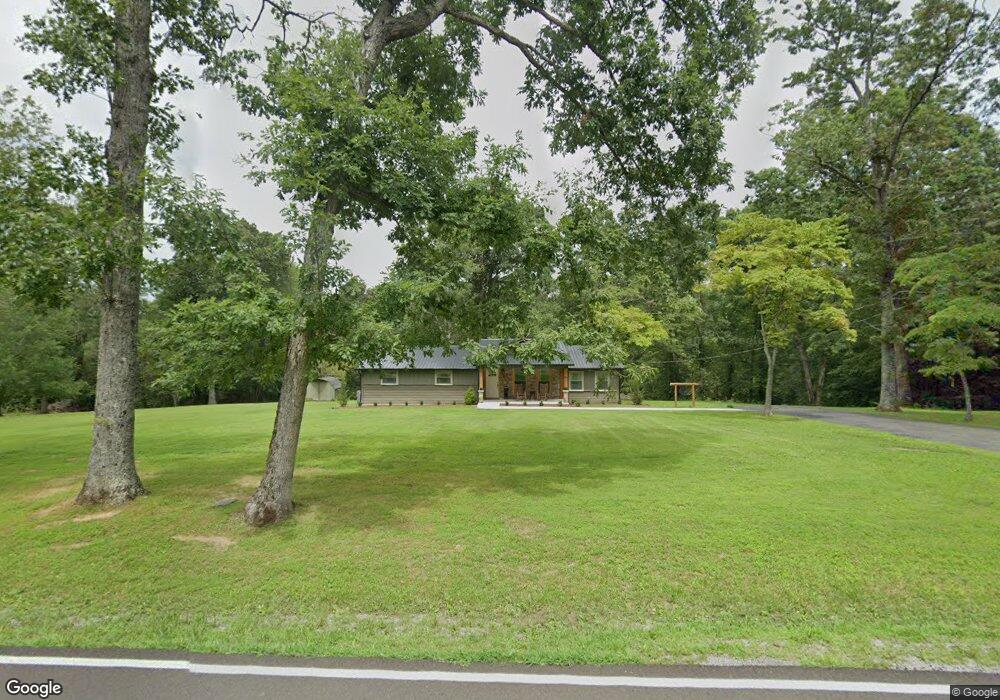
41 Deweese Rd Pikeville, TN 37367
Estimated Value: $222,000 - $464,177
--
Bed
2
Baths
1,466
Sq Ft
$242/Sq Ft
Est. Value
About This Home
This home is located at 41 Deweese Rd, Pikeville, TN 37367 and is currently estimated at $354,392, approximately $241 per square foot. 41 Deweese Rd is a home located in Van Buren County with nearby schools including Spencer Elementary School and Van Buren County High School.
Ownership History
Date
Name
Owned For
Owner Type
Purchase Details
Closed on
Jan 26, 2001
Current Estimated Value
Purchase Details
Closed on
Jul 1, 1996
Purchase Details
Closed on
Nov 30, 1995
Purchase Details
Closed on
Apr 18, 1987
Purchase Details
Closed on
Oct 24, 1986
Bought by
Holloway Larry and Holloway Zonda
Purchase Details
Closed on
Aug 27, 1985
Bought by
Holloway Larry and Holloway Zonda
Purchase Details
Closed on
Jan 1, 1978
Purchase Details
Closed on
Jul 30, 1965
Purchase Details
Closed on
Jan 2, 1900
Create a Home Valuation Report for This Property
The Home Valuation Report is an in-depth analysis detailing your home's value as well as a comparison with similar homes in the area
Home Values in the Area
Average Home Value in this Area
Purchase History
| Date | Buyer | Sale Price | Title Company |
|---|---|---|---|
| -- | -- | -- | |
| -- | -- | -- | |
| -- | -- | -- | |
| -- | -- | -- | |
| Holloway Larry | $38,500 | -- | |
| Holloway Larry | $3,500 | -- | |
| -- | $6,000 | -- | |
| -- | -- | -- | |
| -- | -- | -- |
Source: Public Records
Tax History Compared to Growth
Tax History
| Year | Tax Paid | Tax Assessment Tax Assessment Total Assessment is a certain percentage of the fair market value that is determined by local assessors to be the total taxable value of land and additions on the property. | Land | Improvement |
|---|---|---|---|---|
| 2024 | $2,632 | $109,675 | $7,875 | $101,800 |
| 2023 | $2,632 | $109,675 | $7,875 | $101,800 |
| 2022 | $2,632 | $109,675 | $7,875 | $101,800 |
| 2021 | $2,632 | $109,675 | $7,875 | $101,800 |
| 2020 | $2,416 | $109,675 | $7,875 | $101,800 |
| 2019 | $2,022 | $87,550 | $7,225 | $80,325 |
| 2018 | $1,638 | $87,550 | $7,225 | $80,325 |
| 2017 | $1,638 | $84,875 | $7,225 | $77,650 |
| 2016 | $1,638 | $84,875 | $7,225 | $77,650 |
| 2015 | $1,638 | $84,875 | $7,225 | $77,650 |
| 2014 | $1,583 | $84,875 | $7,225 | $77,650 |
| 2013 | $1,583 | $86,490 | $0 | $0 |
Source: Public Records
Map
Nearby Homes
- 36 Short Rd
- 121 Twin Oaks Rd
- 0 Joe Groves Rd
- 2195 Myers Rd
- 0 High Meadow Dr Unit 1296264
- 0 High Meadow Dr Unit RTC2814513
- 10 Meadow Brook Ln
- 11 Camp Creek Dr
- 122 Camp Creek Dr
- 0 Camp Creek Rd Unit RTC3013168
- Lot 141 Camp Creek Cir
- 0 Bald Knob Rd Unit 1293104
- 131 Camp Creek Cir
- 122 Camp Creek Cir
- Lot 136 Camp Creek Cir
- 141 Camp Creek Cir
- Lot 31 High Meadow Dr
- 00 High Meadow Dr
- Lot 72 Camp Creek Rd
- 20,21,22 Camp Creek Rd