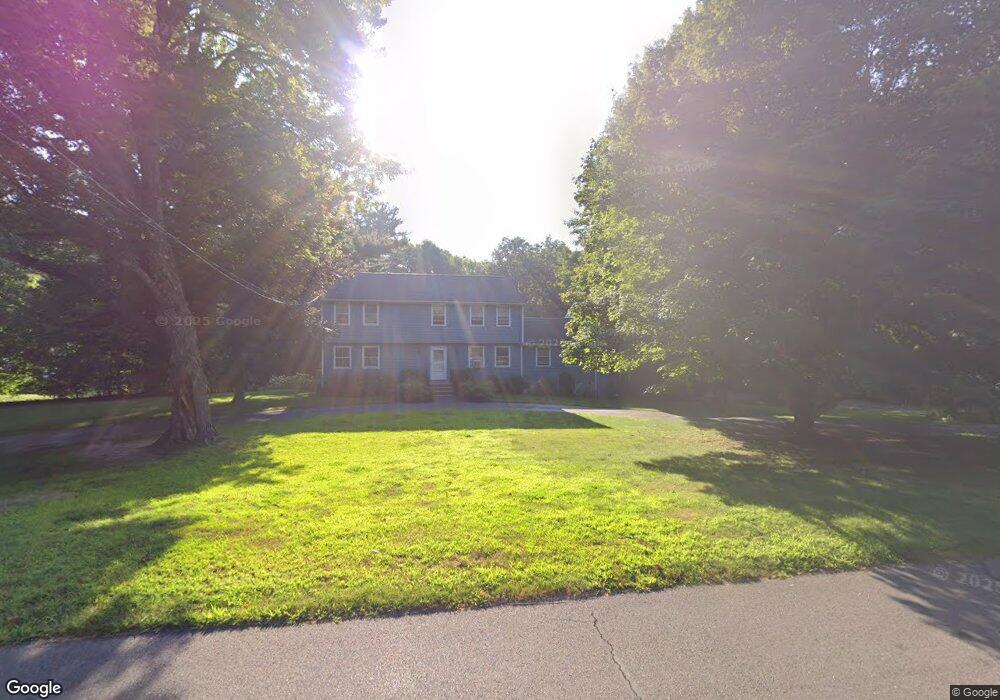
41 Drumlin Rd West Simsbury, CT 06092
Estimated Value: $691,913 - $828,000
5
Beds
3
Baths
3,046
Sq Ft
$248/Sq Ft
Est. Value
About This Home
This home is located at 41 Drumlin Rd, West Simsbury, CT 06092 and is currently estimated at $755,978, approximately $248 per square foot. 41 Drumlin Rd is a home located in Hartford County with nearby schools including Tootin' Hills School, Henry James Memorial School, and Simsbury High School.
Ownership History
Date
Name
Owned For
Owner Type
Purchase Details
Closed on
Aug 4, 2011
Sold by
Kruse Peter W and Kruse Caroline D
Bought by
Shugrue Christian W and Shugrue Bonnie K
Current Estimated Value
Home Financials for this Owner
Home Financials are based on the most recent Mortgage that was taken out on this home.
Original Mortgage
$314,250
Interest Rate
4.51%
Purchase Details
Closed on
Jul 31, 1995
Sold by
Dietzer James M and Dietzer Evelyn P
Bought by
Donald J Czarneski Llc
Purchase Details
Closed on
Jul 27, 1995
Sold by
Palmer Frederick and Palmer Florence H
Bought by
Riccardi Brothers Llc
Purchase Details
Closed on
Mar 29, 1993
Sold by
Palka Bernard and Palka Lori
Bought by
Giard Kevin and Giard Tina
Purchase Details
Closed on
Aug 9, 1988
Sold by
Thorpe Thomas
Bought by
Kruse Peter
Create a Home Valuation Report for This Property
The Home Valuation Report is an in-depth analysis detailing your home's value as well as a comparison with similar homes in the area
Home Values in the Area
Average Home Value in this Area
Purchase History
| Date | Buyer | Sale Price | Title Company |
|---|---|---|---|
| Shugrue Christian W | $419,000 | -- | |
| Donald J Czarneski Llc | $10,000 | -- | |
| Riccardi Brothers Llc | $550,000 | -- | |
| Giard Kevin | $120,000 | -- | |
| Kruse Peter | $385,000 | -- |
Source: Public Records
Mortgage History
| Date | Status | Borrower | Loan Amount |
|---|---|---|---|
| Open | Kruse Peter | $309,900 | |
| Closed | Kruse Peter | $314,250 | |
| Previous Owner | Kruse Peter | $50,000 |
Source: Public Records
Tax History Compared to Growth
Tax History
| Year | Tax Paid | Tax Assessment Tax Assessment Total Assessment is a certain percentage of the fair market value that is determined by local assessors to be the total taxable value of land and additions on the property. | Land | Improvement |
|---|---|---|---|---|
| 2025 | $11,978 | $350,630 | $94,500 | $256,130 |
| 2024 | $11,679 | $350,630 | $94,500 | $256,130 |
| 2023 | $11,157 | $350,630 | $94,500 | $256,130 |
| 2022 | $11,033 | $285,600 | $101,510 | $184,090 |
| 2021 | $11,033 | $285,600 | $101,510 | $184,090 |
| 2020 | $10,593 | $285,600 | $101,510 | $184,090 |
| 2019 | $10,659 | $285,600 | $101,510 | $184,090 |
| 2018 | $10,736 | $285,600 | $101,510 | $184,090 |
| 2017 | $10,223 | $263,740 | $105,840 | $157,900 |
| 2016 | $9,790 | $263,740 | $105,840 | $157,900 |
| 2015 | $9,790 | $263,740 | $105,840 | $157,900 |
| 2014 | $9,795 | $263,740 | $105,840 | $157,900 |
Source: Public Records
Map
Nearby Homes
- 24 Drumlin Rd
- 370A W Mountain Rd
- 395 Bushy Hill Rd
- 14 Nod Brook Dr
- 1 Alcima Dr
- 41 Applegate Ln
- 3 Applegate Ln Unit 3
- 31 Applegate Ln Unit 31
- 49 Applegate Ln Unit 49
- 41 Secret Lake Rd
- 8 Crane Place
- 54 Secret Lake Rd
- 19 Glenbrook Dr
- 121 Gracey Rd
- 301 Bushy Hill Rd
- 6 Highwood Rd
- 302 Bushy Hill Rd
- 18 Sunset Trail
- 70 Trailsend Dr
- 25 Tall Wood Hollow