
Seller's Agent in 2025
Julie Carney
William Raveis Real Estate
(203) 451-9966
33 in this area
49 Total Sales
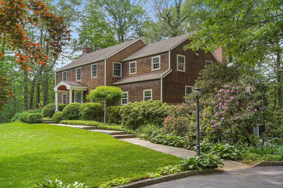
A trifecta of features, fabulous location, impeccable condition, beautiful Christopher Peacock kitchen, updated baths, large Primary Suite/office and four additional bedrooms. Gorgeous outdoor patio with full size fireplace. Located next to Cherry Lane Park great for privacy and hiking. Just 5 minutes from town, 7 minutes to all Wilton schools, 17 minutes to Westport train and 18 minutes to SONO train. Join the Little Brook neighborhood and you will never want to leave. A community feel close to everything you want. This is the one you've been waiting for!
Last Agent to Sell the Property
William Raveis Real Estate License #RES.0766123 Listed on: 06/02/2025
| Date | Type | Sale Price | Title Company |
|---|---|---|---|
| Warranty Deed | $447,000 | -- |
| Date | Status | Loan Amount | Loan Type |
|---|---|---|---|
| Open | $750,000 | Adjustable Rate Mortgage/ARM | |
| Closed | $415,000 | No Value Available |
| Date | Event | Price | List to Sale | Price per Sq Ft |
|---|---|---|---|---|
| 07/11/2025 07/11/25 | Sold | $1,800,000 | +14.7% | $404 / Sq Ft |
| 06/14/2025 06/14/25 | Pending | -- | -- | -- |
| 06/05/2025 06/05/25 | For Sale | $1,569,000 | -- | $352 / Sq Ft |
| Year | Tax Paid | Tax Assessment Tax Assessment Total Assessment is a certain percentage of the fair market value that is determined by local assessors to be the total taxable value of land and additions on the property. | Land | Improvement |
|---|---|---|---|---|
| 2025 | $19,797 | $811,020 | $326,410 | $484,610 |
| 2024 | $19,416 | $811,020 | $326,410 | $484,610 |
| 2023 | $23,325 | $612,710 | $312,060 | $300,650 |
| 2022 | $17,297 | $612,710 | $312,060 | $300,650 |
| 2021 | $17,076 | $612,710 | $312,060 | $300,650 |
| 2020 | $16,825 | $612,710 | $312,060 | $300,650 |
| 2019 | $17,487 | $612,710 | $312,060 | $300,650 |
| 2018 | $16,248 | $576,380 | $327,320 | $249,060 |
| 2017 | $30,864 | $576,380 | $327,320 | $249,060 |
| 2016 | $15,758 | $576,380 | $327,320 | $249,060 |
| 2015 | $15,464 | $576,380 | $327,320 | $249,060 |
| 2014 | $15,280 | $576,380 | $327,320 | $249,060 |
Seller's Agent in 2025
Julie Carney
William Raveis Real Estate
(203) 451-9966
33 in this area
49 Total Sales
Buyer's Agent in 2025
Amy Barsanti
William Pitt
(203) 722-1781
1 in this area
51 Total Sales
Source: SmartMLS
MLS Number: 24093757
APN: WILT-000030-000010
Disclaimer: Certain information contained herein is derived from information provided by parties other than Homes.com. All information provided is deemed reliable, but is not guaranteed to be accurate and should be independently verified.
![]() IDX information is provided exclusively for personal, non-commercial use, and may not be used for any purpose other than to identify prospective properties consumers may be interested in purchasing. Information is deemed reliable but not guaranteed.
IDX information is provided exclusively for personal, non-commercial use, and may not be used for any purpose other than to identify prospective properties consumers may be interested in purchasing. Information is deemed reliable but not guaranteed.