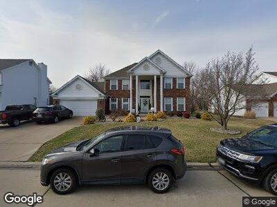
41 Muirfield Point Ln Saint Charles, MO 63304
Estimated Value: $497,879 - $602,000
4
Beds
3
Baths
2,559
Sq Ft
$211/Sq Ft
Est. Value
About This Home
This home is located at 41 Muirfield Point Ln, Saint Charles, MO 63304 and is currently estimated at $540,970, approximately $211 per square foot. 41 Muirfield Point Ln is a home located in St. Charles County with nearby schools including Independence Elementary School, Bryan Middle School, and Francis Howell Union High School.
Ownership History
Date
Name
Owned For
Owner Type
Purchase Details
Closed on
Jun 29, 1998
Sold by
Allegiant Bank
Bought by
Loos Kevin J and Loos Susan A
Current Estimated Value
Home Financials for this Owner
Home Financials are based on the most recent Mortgage that was taken out on this home.
Original Mortgage
$155,000
Outstanding Balance
$36,274
Interest Rate
7.13%
Estimated Equity
$504,696
Purchase Details
Closed on
May 6, 1998
Sold by
Overy Guy M Debra L
Bought by
Allegiant Bank
Home Financials for this Owner
Home Financials are based on the most recent Mortgage that was taken out on this home.
Original Mortgage
$155,000
Outstanding Balance
$36,274
Interest Rate
7.13%
Estimated Equity
$504,696
Create a Home Valuation Report for This Property
The Home Valuation Report is an in-depth analysis detailing your home's value as well as a comparison with similar homes in the area
Home Values in the Area
Average Home Value in this Area
Purchase History
| Date | Buyer | Sale Price | Title Company |
|---|---|---|---|
| Loos Kevin J | $195,000 | -- | |
| Allegiant Bank | -- | -- |
Source: Public Records
Mortgage History
| Date | Status | Borrower | Loan Amount |
|---|---|---|---|
| Open | Loos Kevin J | $155,000 |
Source: Public Records
Tax History Compared to Growth
Tax History
| Year | Tax Paid | Tax Assessment Tax Assessment Total Assessment is a certain percentage of the fair market value that is determined by local assessors to be the total taxable value of land and additions on the property. | Land | Improvement |
|---|---|---|---|---|
| 2023 | $4,973 | $83,451 | $0 | $0 |
| 2022 | $4,129 | $64,302 | $0 | $0 |
| 2021 | $4,133 | $64,302 | $0 | $0 |
| 2020 | $4,324 | $65,149 | $0 | $0 |
| 2019 | $4,304 | $65,149 | $0 | $0 |
| 2018 | $3,923 | $56,742 | $0 | $0 |
| 2017 | $3,891 | $56,742 | $0 | $0 |
| 2016 | $3,940 | $55,351 | $0 | $0 |
| 2015 | $3,904 | $55,351 | $0 | $0 |
| 2014 | $3,820 | $52,542 | $0 | $0 |
Source: Public Records
Map
Nearby Homes
- 234 Summit Ridge Place
- 663 Clifden Dr
- 32 Windcastle Dr
- 4227 Towers Rd
- 30 Pitman Hill Rd
- 4242 Austin Ridge Dr
- 69 Castle Bluff Dr
- 814 Haversham Dr
- 4 Upper Whitmoor Dr
- 603 Jacobs Station Rd
- 4516 Austin Point Ct
- 715 Cullenmor Hill Dr
- 4304 Austin Pass Ct
- 738 Jacobs Station Rd
- 859 Whitmoor Dr
- 851 Whitmoor Dr
- 4053 Towers Rd
- 4051 Towers Rd
- 263 Ashdown Forest Ct
- 4463 Austin Meadows Ct
- 41 Muirfield Point Ln
- 42 Muirfield Point Ln
- 40 Muirfield Point Ln
- 35 Muirfield Hill Ct S
- 34 Muirfield Hill Ct S
- 43 Muirfield Point Ln
- 36 Muirfield Hill Ct S
- 55 Muirfield Point Ln
- 33 Muirfield Hill Ct S
- 50 Muirfield Point Ln
- 44 Muirfield Point Ln
- 446 Muirfield Dr
- 441 Muirfield Dr
- 445 Muirfield Dr
- 32 Muirfield Hill Ct S
- 437 Muirfield Dr
- 51 Muirfield Point Ct
- 21 Muirfield Hill Ct S
- 22 Muirfield Ridge Ct
- 20 Muirfield Hill Ct S