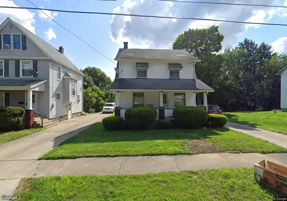
41 N Portland Ave Youngstown, OH 44509
Belle Vista NeighborhoodEstimated Value: $58,000 - $89,000
4
Beds
1
Bath
1,240
Sq Ft
$63/Sq Ft
Est. Value
About This Home
This home is located at 41 N Portland Ave, Youngstown, OH 44509 and is currently estimated at $77,895, approximately $62 per square foot. 41 N Portland Ave is a home located in Mahoning County with nearby schools including Volney Rogers Elementary School, Chaney High School, and Summit Academy - Youngstown.
Ownership History
Date
Name
Owned For
Owner Type
Purchase Details
Closed on
Jul 7, 2021
Bought by
Pre Meer Property
Current Estimated Value
Home Financials for this Owner
Home Financials are based on the most recent Mortgage that was taken out on this home.
Interest Rate
2.98%
Purchase Details
Closed on
Feb 29, 2012
Sold by
Romack David H and Romack Marilyn K
Bought by
Karda Holdings Lp
Purchase Details
Closed on
Feb 23, 2012
Sold by
Estate Of Brenda L Romack
Bought by
Romack David H and Romack Donna
Purchase Details
Closed on
Feb 11, 1991
Bought by
Romack Brenda L
Create a Home Valuation Report for This Property
The Home Valuation Report is an in-depth analysis detailing your home's value as well as a comparison with similar homes in the area
Home Values in the Area
Average Home Value in this Area
Purchase History
| Date | Buyer | Sale Price | Title Company |
|---|---|---|---|
| Pre Meer Property | $22,222 | -- | |
| Karda Holdings Lp | $14,000 | Attorney | |
| Romack David H | -- | None Available | |
| Romack Brenda L | $29,500 | -- |
Source: Public Records
Mortgage History
| Date | Status | Borrower | Loan Amount |
|---|---|---|---|
| Closed | Pre Meer Property | -- |
Source: Public Records
Tax History Compared to Growth
Tax History
| Year | Tax Paid | Tax Assessment Tax Assessment Total Assessment is a certain percentage of the fair market value that is determined by local assessors to be the total taxable value of land and additions on the property. | Land | Improvement |
|---|---|---|---|---|
| 2024 | $663 | $13,530 | $1,070 | $12,460 |
| 2023 | $658 | $13,530 | $1,070 | $12,460 |
| 2022 | $615 | $9,730 | $1,060 | $8,670 |
| 2021 | $615 | $9,730 | $1,060 | $8,670 |
| 2020 | $618 | $9,730 | $1,060 | $8,670 |
| 2019 | $606 | $8,530 | $930 | $7,600 |
| 2018 | $612 | $8,530 | $930 | $7,600 |
| 2017 | $459 | $8,530 | $930 | $7,600 |
| 2016 | $309 | $4,640 | $1,430 | $3,210 |
| 2015 | $438 | $6,720 | $1,430 | $5,290 |
| 2014 | $435 | $6,720 | $1,430 | $5,290 |
| 2013 | $630 | $10,180 | $1,430 | $8,750 |
Source: Public Records
Map
Nearby Homes
- 60 Steel St
- 1751 Mahoning Ave
- 15 S Portland Ave
- 219 N Maryland Ave
- 77 Fernwood Ave
- 1711 Wellington Ave
- 1595 2nd St
- 1594 2nd St
- 1611 Wellington Ave
- 134 Millet Ave
- 115 N Richview Ave
- 1947 Manhattan Ave
- 1726 Midland Ave
- 2113 Manhattan Ave
- 112 Glacier Ave
- 1516 Midland Ave
- 1639 Butler Ave
- 107 N Hartford Ave
- 234 S Portland Ave
- 28 N Hartford Ave
- 41 N Portland Ave
- 37 N Portland Ave
- 37 N Portland Ave
- 51 N Portland Ave
- 35 N Portland Ave
- 101 N Portland Ave
- 31 N Portland Ave
- 103 N Portland Ave
- 103 N Portland Ave
- 46 N Lakeview Ave
- 42 N Lakeview Ave
- 50 N Lakeview Ave
- 42 N Portland Ave
- 36 N Lakeview Ave
- 54 N Lakeview Ave
- 29 N Portland Ave
- 107 N Portland Ave
- 104 N Lakeview Ave
- 38 N Portland Ave
- 38 N Portland Ave