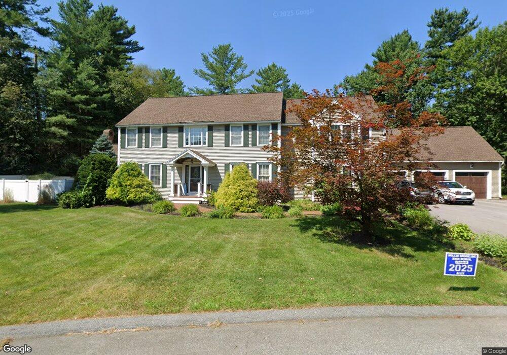
41 Swallow Dr Hollis, NH 03049
Hollis NeighborhoodEstimated Value: $1,158,000 - $1,384,000
4
Beds
3
Baths
3,588
Sq Ft
$347/Sq Ft
Est. Value
About This Home
This home is located at 41 Swallow Dr, Hollis, NH 03049 and is currently estimated at $1,245,289, approximately $347 per square foot. 41 Swallow Dr is a home located in Hillsborough County with nearby schools including Hollis Primary School, Hollis Upper Elementary School, and Hollis-Brookline Middle School.
Ownership History
Date
Name
Owned For
Owner Type
Purchase Details
Closed on
Jun 16, 2009
Sold by
Weimer Craig J and Weimer Kelly Ann
Bought by
Ditrolio Matthew J and Ditrolio Heather
Current Estimated Value
Home Financials for this Owner
Home Financials are based on the most recent Mortgage that was taken out on this home.
Original Mortgage
$250,000
Interest Rate
4.82%
Mortgage Type
Purchase Money Mortgage
Purchase Details
Closed on
Oct 5, 1998
Sold by
Glendale Homes Inc
Bought by
Weimer Craig J and Weimer Kelly Ann
Home Financials for this Owner
Home Financials are based on the most recent Mortgage that was taken out on this home.
Original Mortgage
$200,000
Interest Rate
6.89%
Create a Home Valuation Report for This Property
The Home Valuation Report is an in-depth analysis detailing your home's value as well as a comparison with similar homes in the area
Home Values in the Area
Average Home Value in this Area
Purchase History
| Date | Buyer | Sale Price | Title Company |
|---|---|---|---|
| Ditrolio Matthew J | $520,000 | -- | |
| Weimer Craig J | $266,100 | -- |
Source: Public Records
Mortgage History
| Date | Status | Borrower | Loan Amount |
|---|---|---|---|
| Open | Weimer Craig J | $35,000 | |
| Open | Weimer Craig J | $245,000 | |
| Closed | Weimer Craig J | $250,000 | |
| Previous Owner | Weimer Craig J | $200,000 |
Source: Public Records
Tax History Compared to Growth
Tax History
| Year | Tax Paid | Tax Assessment Tax Assessment Total Assessment is a certain percentage of the fair market value that is determined by local assessors to be the total taxable value of land and additions on the property. | Land | Improvement |
|---|---|---|---|---|
| 2024 | $18,680 | $1,053,600 | $266,600 | $787,000 |
| 2023 | $17,553 | $1,053,600 | $266,600 | $787,000 |
| 2022 | $23,780 | $1,053,600 | $266,600 | $787,000 |
| 2021 | $14,353 | $632,300 | $170,700 | $461,600 |
| 2020 | $14,657 | $632,300 | $170,700 | $461,600 |
| 2019 | $14,606 | $632,300 | $170,700 | $461,600 |
| 2018 | $13,702 | $632,300 | $170,700 | $461,600 |
| 2017 | $12,770 | $551,600 | $146,100 | $405,500 |
| 2016 | $12,924 | $551,600 | $146,100 | $405,500 |
| 2015 | $9,675 | $420,300 | $146,100 | $274,200 |
| 2014 | $9,722 | $420,300 | $146,100 | $274,200 |
| 2013 | $9,591 | $420,300 | $146,100 | $274,200 |
Source: Public Records
Map
Nearby Homes
- 75 Deerwood Dr Unit B
- 77 Mooar Hill Rd
- 5 Dumaine Ave Unit B
- 5 Dumaine Ave Unit N
- 3 Roedean Dr Unit C-207
- 201 Millwright Dr
- 4-13 Woodmont Dr
- 199 Pine Hill Rd
- 26 Andover Down Unit 276
- 10 Drouin Way
- 3 Cranleigh Mews Unit U297
- 25 Eastern Ave
- 36 Hampton Dr
- 5 Chatfield Dr Unit U18
- 40-40A Pine Hill Rd
- 15 Four Winds Rd
- 102 Silver Lake Rd
- 334 Broad St
- 2 Broadcrest Ln
- 118 Broad St