
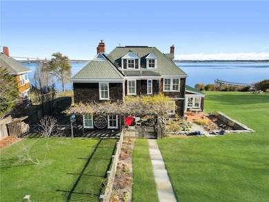


41 Walcott Ave Jamestown, RI 02835
Jamestown Village NeighborhoodEstimated payment $42,789/month
Highlights
- Hot Property
- Beach Front
- Golf Course Community
- Melrose Avenue School Rated A-
- Marina
- Water Access
About This Home
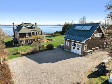
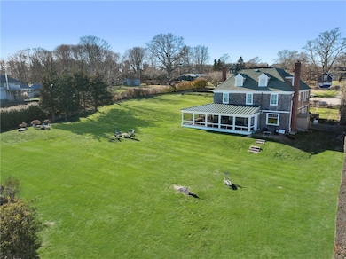
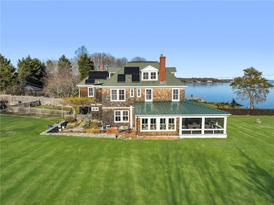
This unique offering presents a rare waterfront shingled cottage, built 1893. This property has two moorings currently with panoramic water views towards the east side of Narragansett Bay. There is the possibility of a dock and there are steps down to a slate patio by the water. This home is sited on a 27,955 sq.ft. lot with a comfortable floor plan. The first level consists of a welcoming entry, mudroom, eat in kitchen, butler's pantry, dining room w/ gas fireplace, living room w/ a wood insert, an expansive hallway leading onto the wraparound waterfront screened in porch, 18' wide by 39' long. It's perfect for gatherings with privacy and easy access to open water, making it convenient for swimming, fishing, or a boat ride. First level continues with a family room/study that could be a bedroom, a year-round sun room with a brick floor and radiant heat, pantry/laundry room and full bath. Second level features 4 en suites, an office and a media room. Third level has two additional bedrooms, recreation room and a full bath. An artists studio, built in 2015, is a few steps away from the main residence. A separate waterfront lot is available for sale with this property, MLS#1401347, this lot will not sell on its own. In addition, MLS #1399629, a second home with a guest cottage and two outbuildings, is also available for sale. Opportunities to acquire such a versatile compound/estate are a once-in-a-generation occurrence. Coastal living, in town, at its absolute finest!
Home Details
Home Type
- Single Family
Est. Annual Taxes
- $22,892
Year Built
- Built in 1893
Lot Details
- 0.64 Acre Lot
- Beach Front
- Property is zoned R40
Home Design
- Combination Foundation
- Wood Siding
- Shingle Siding
Interior Spaces
- 4,927 Sq Ft Home
- 3-Story Property
- 2 Fireplaces
- Wood Burning Fireplace
- Self Contained Fireplace Unit Or Insert
- Fireplace Features Masonry
- Gas Fireplace
- Thermal Windows
- Storage Room
- Utility Room
Flooring
- Wood
- Carpet
Bedrooms and Bathrooms
- 6 Bedrooms
- 6 Full Bathrooms
- Bathtub with Shower
Unfinished Basement
- Basement Fills Entire Space Under The House
- Interior and Exterior Basement Entry
Parking
- 6 Parking Spaces
- No Garage
Outdoor Features
- Water Access
- Walking Distance to Water
- Mooring
- Screened Patio
- Outbuilding
- Porch
Location
- Property near a hospital
Utilities
- No Cooling
- Zoned Heating
- Heating System Uses Propane
- Heating System Uses Wood
- Hot Water Heating System
- 200+ Amp Service
- Power Generator
- Gas Water Heater
- Septic Tank
Listing and Financial Details
- Tax Lot 297
- Assessor Parcel Number 41WALCOTTAVJAME
Community Details
Overview
- Village, In Town Subdivision
Amenities
- Shops
- Restaurant
- Public Transportation
Recreation
- Marina
- Golf Course Community
- Tennis Courts
- Recreation Facilities
Map
Home Values in the Area
Average Home Value in this Area
Tax History
| Year | Tax Paid | Tax Assessment Tax Assessment Total Assessment is a certain percentage of the fair market value that is determined by local assessors to be the total taxable value of land and additions on the property. | Land | Improvement |
|---|---|---|---|---|
| 2025 | $22,872 | $4,055,400 | $2,904,900 | $1,150,500 |
| 2024 | $25,233 | $3,519,300 | $2,384,100 | $1,135,200 |
| 2023 | $24,576 | $3,520,900 | $2,384,100 | $1,136,800 |
| 2022 | $23,907 | $3,520,900 | $2,384,100 | $1,136,800 |
| 2021 | $27,816 | $3,359,400 | $2,601,300 | $758,100 |
| 2020 | $27,110 | $3,359,400 | $2,601,300 | $758,100 |
| 2019 | $27,299 | $3,391,200 | $2,601,300 | $789,900 |
| 2018 | $20,260 | $2,289,300 | $1,719,700 | $569,600 |
| 2017 | $19,825 | $2,289,300 | $1,719,700 | $569,600 |
| 2016 | $19,639 | $2,288,900 | $1,719,700 | $569,200 |
| 2015 | $19,499 | $2,220,800 | $1,623,300 | $597,500 |
| 2014 | $19,352 | $2,211,600 | $1,623,300 | $588,300 |
Property History
| Date | Event | Price | List to Sale | Price per Sq Ft |
|---|---|---|---|---|
| 12/07/2025 12/07/25 | For Sale | $7,795,000 | -- | $1,582 / Sq Ft |
Purchase History
| Date | Type | Sale Price | Title Company |
|---|---|---|---|
| Warranty Deed | -- | None Available | |
| Warranty Deed | -- | None Available | |
| Deed | $2,975,000 | -- | |
| Deed | $2,500,000 | -- |
Mortgage History
| Date | Status | Loan Amount | Loan Type |
|---|---|---|---|
| Previous Owner | $1,410,000 | Adjustable Rate Mortgage/ARM | |
| Previous Owner | $1,400,000 | Purchase Money Mortgage |
Source: State-Wide MLS
MLS Number: 1401345
APN: JAME-000009-000000-000297
Disclaimer: Certain information contained herein is derived from information provided by parties other than Homes.com. All information provided is deemed reliable, but is not guaranteed to be accurate and should be independently verified.
![]() IDX information is provided exclusively for personal, non-commercial use, and may not be used for any purpose other than to identify prospective properties consumers may be interested in purchasing. Information is deemed reliable but not guaranteed.
IDX information is provided exclusively for personal, non-commercial use, and may not be used for any purpose other than to identify prospective properties consumers may be interested in purchasing. Information is deemed reliable but not guaranteed.
Copyright © 2025 State-Wide MLS, Inc. All rights reserved.
- 39 Walcott Ave
- 0 Walcott Ave
- 20 Lincoln St
- 104 Howland Ave
- 73 Conanicus Ave Unit 4
- 22 Cole St
- 63 Longfellow Rd
- 46 North Rd
- 48 Ocean Ave
- 76 Battery Ln
- 65 Ridge Rd Unit P37
- 30 Bonnet View Dr
- 21 Bonnet View Dr
- 10 Coulter St
- 41 Castle Hill Ave
- 127 Harrison Ave Unit 10
- 15 Hammersmith Rd Unit 31
- 111 Harrison Ave Unit 9
- 23 Willow St
- 4 Clarkes Village Ln
- 21 Baldwin Ct
- 67 High St
- 9 Union St Unit 2
- 9 Union St Unit 1
- 28 Newport St
- 72 Ledge Rd
- 953 Fort Getty Rd
- 381 Jackson Rd
- 1204 Capella S
- 1412 Capella S
- 20 America Unit B
- 58 Ridge Rd
- 1 Ella Terrace
- 157 Harrison Ave Unit 15
- 317 America
- 591 Ocean Ave
- 17 Chartier Cir
- 15 Hammersmith Rd Unit 33
- 3 Doris Terrace
- 41 Washington St
