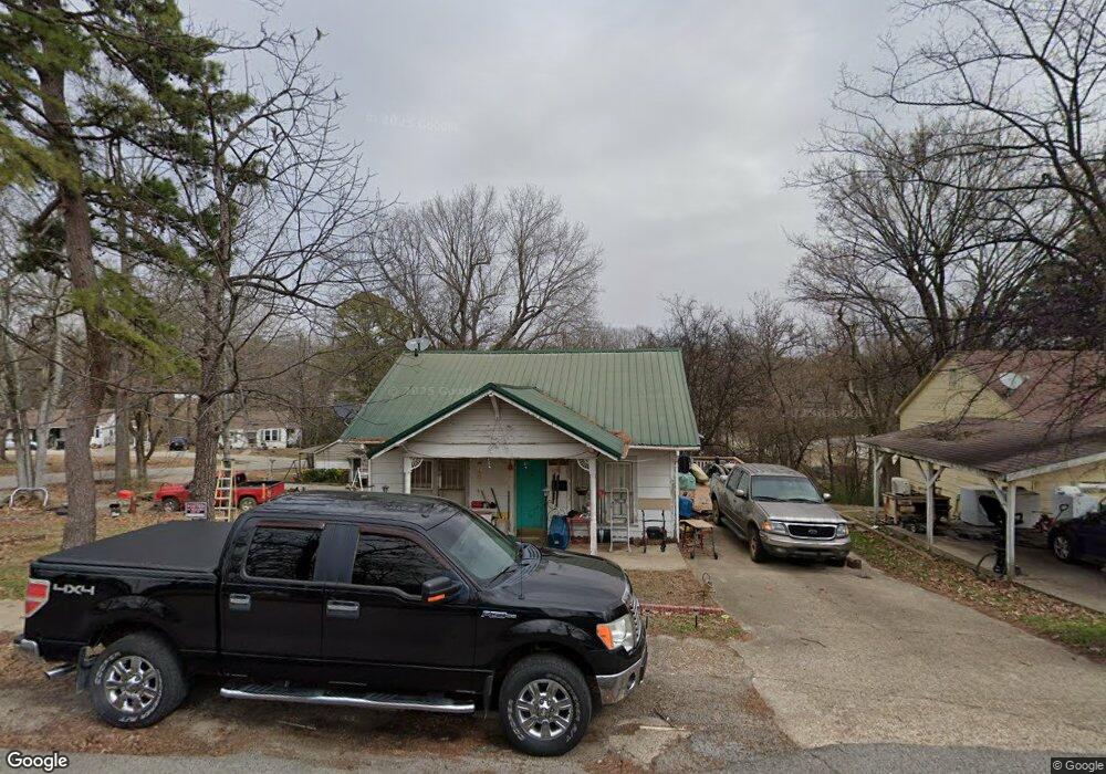
410 Bland St Pocahontas, AR 72455
Estimated Value: $46,000 - $63,000
--
Bed
1
Bath
702
Sq Ft
$75/Sq Ft
Est. Value
About This Home
This home is located at 410 Bland St, Pocahontas, AR 72455 and is currently estimated at $52,935, approximately $75 per square foot. 410 Bland St is a home located in Randolph County with nearby schools including Pocahontas Elementary School, M.D. Williams Middle School, and Pocahontas Junior High School.
Ownership History
Date
Name
Owned For
Owner Type
Purchase Details
Closed on
Jul 28, 2021
Sold by
Cousins Doug
Bought by
Oetjen Terry and Oetjen Carolyn
Current Estimated Value
Purchase Details
Closed on
May 21, 2012
Sold by
Roberts Pamela Diane
Bought by
Cousins Douglas
Purchase Details
Closed on
Sep 26, 2007
Bought by
Archer To Cousins
Purchase Details
Closed on
Sep 24, 2004
Bought by
Weaver To Cousins
Purchase Details
Closed on
Oct 10, 2001
Bought by
Risenhoover To Weaver
Purchase Details
Closed on
Jan 5, 1998
Bought by
Risenhoover Charles and Risenhoover Janice
Purchase Details
Closed on
Mar 1, 1990
Bought by
Snow To Simpson
Purchase Details
Closed on
Jan 1, 1986
Bought by
Martin To Snow
Create a Home Valuation Report for This Property
The Home Valuation Report is an in-depth analysis detailing your home's value as well as a comparison with similar homes in the area
Home Values in the Area
Average Home Value in this Area
Purchase History
| Date | Buyer | Sale Price | Title Company |
|---|---|---|---|
| Oetjen Terry | $28,000 | None Available | |
| Cousins Douglas | -- | -- | |
| Archer To Cousins | -- | -- | |
| Weaver To Cousins | $17,000 | -- | |
| Risenhoover To Weaver | $19,000 | -- | |
| Risenhoover Charles | $20,000 | -- | |
| Snow To Simpson | $14,000 | -- | |
| Martin To Snow | -- | -- |
Source: Public Records
Tax History Compared to Growth
Tax History
| Year | Tax Paid | Tax Assessment Tax Assessment Total Assessment is a certain percentage of the fair market value that is determined by local assessors to be the total taxable value of land and additions on the property. | Land | Improvement |
|---|---|---|---|---|
| 2025 | -- | $5,170 | $1,000 | $4,170 |
| 2024 | -- | $5,170 | $1,000 | $4,170 |
| 2023 | $0 | $5,170 | $1,000 | $4,170 |
| 2022 | $0 | $5,170 | $1,000 | $4,170 |
| 2021 | $2,434 | $5,170 | $1,000 | $4,170 |
| 2020 | $0 | $4,535 | $1,000 | $3,535 |
| 2019 | $0 | $4,535 | $1,000 | $3,535 |
| 2018 | $0 | $4,535 | $1,000 | $3,535 |
| 2017 | $0 | $5,740 | $1,000 | $4,740 |
| 2016 | -- | $5,740 | $1,000 | $4,740 |
| 2015 | -- | $5,740 | $1,000 | $4,740 |
| 2014 | -- | $5,740 | $1,000 | $4,740 |
Source: Public Records
Map
Nearby Homes
- 403 Bland St
- 708 N Thomasville St
- 601 W Black St
- 801 Dalton St
- 415 W Pine St
- 1305 Witt St
- 1403 N Bryant St
- 613 W Pine St
- 501 N Marr St
- 1819 Highway 304e
- tbd U S Highway 62
- TBD U S Highway 67
- 805 W Pyburn St
- 113 W Pyburn St
- 214 N Marr St
- 3332 U S Highway 62
- 107 N Marr St
- Haynes St
- 107 E Broadway St
- 215 E Broadway St