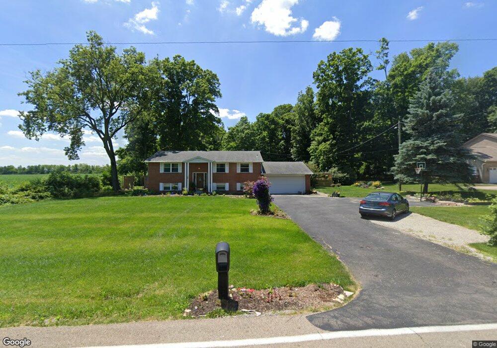
410 Michaels Rd Tipp City, OH 45371
Estimated Value: $343,617 - $369,000
3
Beds
3
Baths
2,294
Sq Ft
$155/Sq Ft
Est. Value
About This Home
This home is located at 410 Michaels Rd, Tipp City, OH 45371 and is currently estimated at $356,654, approximately $155 per square foot. 410 Michaels Rd is a home located in Miami County with nearby schools including Broadway Elementary School, Nevin Coppock Elementary School, and L. T. Ball Intermediate School.
Ownership History
Date
Name
Owned For
Owner Type
Purchase Details
Closed on
Dec 6, 2019
Sold by
Iaquinta Heather and Iaquinta Heather R
Bought by
Iaquinta Heather R and Iaquinta Thomas A
Current Estimated Value
Purchase Details
Closed on
Aug 7, 2019
Sold by
Lackey Gary G and Lackey Charlotte F
Bought by
Iaquinta Heather
Home Financials for this Owner
Home Financials are based on the most recent Mortgage that was taken out on this home.
Original Mortgage
$192,261
Outstanding Balance
$170,239
Interest Rate
4.25%
Mortgage Type
FHA
Estimated Equity
$186,415
Purchase Details
Closed on
Mar 16, 2000
Sold by
Lackey Gary G
Bought by
Lackey Charlotte F and Lackey Gary G
Purchase Details
Closed on
Nov 20, 1991
Bought by
Homyk John M
Create a Home Valuation Report for This Property
The Home Valuation Report is an in-depth analysis detailing your home's value as well as a comparison with similar homes in the area
Home Values in the Area
Average Home Value in this Area
Purchase History
| Date | Buyer | Sale Price | Title Company |
|---|---|---|---|
| Iaquinta Heather R | -- | First Ohio Title Insurance | |
| Iaquinta Heather | $189,900 | None Available | |
| Lackey Charlotte F | -- | -- | |
| Homyk John M | $93,500 | -- |
Source: Public Records
Mortgage History
| Date | Status | Borrower | Loan Amount |
|---|---|---|---|
| Open | Iaquinta Heather | $192,261 |
Source: Public Records
Tax History Compared to Growth
Tax History
| Year | Tax Paid | Tax Assessment Tax Assessment Total Assessment is a certain percentage of the fair market value that is determined by local assessors to be the total taxable value of land and additions on the property. | Land | Improvement |
|---|---|---|---|---|
| 2024 | $4,252 | $80,720 | $18,100 | $62,620 |
| 2023 | $4,252 | $80,720 | $18,100 | $62,620 |
| 2022 | $3,897 | $80,720 | $18,100 | $62,620 |
| 2021 | $3,083 | $59,790 | $13,410 | $46,380 |
| 2020 | $3,121 | $59,790 | $13,410 | $46,380 |
| 2019 | $3,148 | $59,790 | $13,410 | $46,380 |
| 2018 | $2,633 | $46,590 | $12,150 | $34,440 |
| 2017 | $2,642 | $46,590 | $12,150 | $34,440 |
| 2016 | $2,534 | $46,590 | $12,150 | $34,440 |
| 2015 | $2,144 | $41,620 | $10,850 | $30,770 |
| 2014 | $2,144 | $41,620 | $10,850 | $30,770 |
| 2013 | $2,155 | $41,620 | $10,850 | $30,770 |
Source: Public Records
Map
Nearby Homes
- 295 Coach Dr
- 512 Cider Mill Way
- 5998 Sterling Ct
- The Prescott Plan at Fieldstone Place
- The Lynwood Plan at Emerson Crossing
- The Concord Plan at Emerson Crossing
- The Magnolia Plan at Fieldstone Place
- The Cambridge Plan at Emerson Crossing
- The Sandalwood Plan at Fieldstone Place
- The Lincoln Plan at Emerson Crossing
- The Plainfield Plan at Fieldstone Place
- The Cambridge Plan at Fieldstone Place
- The Magnolia Plan at Emerson Crossing
- The Prescott Plan at Emerson Crossing
- The Fieldstone Plan at Emerson Crossing
- The Zink Plan at Fieldstone Place
- The Concord Plan at Fieldstone Place
- The Warren Plan at Fieldstone Place
- The Fieldstone Plan at Fieldstone Place
- The Warren Plan at Emerson Crossing