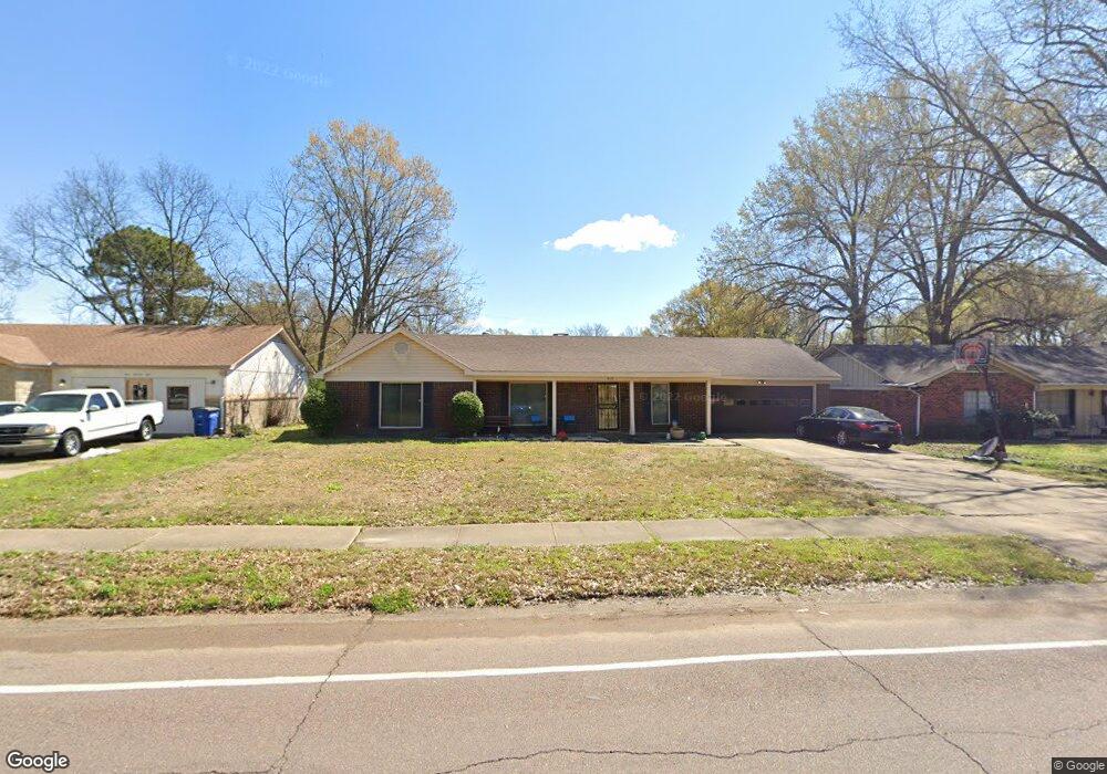
410 Rice St West Memphis, AR 72301
Estimated Value: $157,000 - $186,000
--
Bed
2
Baths
1,524
Sq Ft
$111/Sq Ft
Est. Value
About This Home
This home is located at 410 Rice St, West Memphis, AR 72301 and is currently estimated at $169,289, approximately $111 per square foot. 410 Rice St is a home located in Crittenden County with nearby schools including Faulk Elementary School, Wonder Junior High School, and The Academies of West Memphis Charter School.
Ownership History
Date
Name
Owned For
Owner Type
Purchase Details
Closed on
May 16, 1997
Sold by
Not Provided
Bought by
Byrd John E and Byrd Sharon D
Current Estimated Value
Purchase Details
Closed on
Mar 1, 1988
Bought by
To
Purchase Details
Closed on
Dec 1, 1986
Bought by
To
Purchase Details
Closed on
May 1, 1985
Bought by
To
Purchase Details
Closed on
Mar 1, 1980
Bought by
To
Purchase Details
Closed on
Jun 1, 1978
Bought by
To
Create a Home Valuation Report for This Property
The Home Valuation Report is an in-depth analysis detailing your home's value as well as a comparison with similar homes in the area
Home Values in the Area
Average Home Value in this Area
Purchase History
| Date | Buyer | Sale Price | Title Company |
|---|---|---|---|
| Byrd John E | $76,000 | -- | |
| To | $70,000 | -- | |
| To | $66,000 | -- | |
| To | $62,000 | -- | |
| To | $12,000 | -- | |
| To | $53,000 | -- |
Source: Public Records
Tax History Compared to Growth
Tax History
| Year | Tax Paid | Tax Assessment Tax Assessment Total Assessment is a certain percentage of the fair market value that is determined by local assessors to be the total taxable value of land and additions on the property. | Land | Improvement |
|---|---|---|---|---|
| 2024 | $417 | $19,020 | $3,200 | $15,820 |
| 2023 | $492 | $19,020 | $3,200 | $15,820 |
| 2022 | $542 | $19,020 | $3,200 | $15,820 |
| 2021 | $542 | $19,020 | $3,200 | $15,820 |
| 2020 | $852 | $19,020 | $3,200 | $15,820 |
| 2019 | $489 | $17,900 | $3,200 | $14,700 |
| 2018 | $379 | $17,900 | $3,200 | $14,700 |
| 2017 | $379 | $17,900 | $3,200 | $14,700 |
| 2016 | $379 | $17,900 | $3,200 | $14,700 |
| 2015 | $386 | $17,900 | $3,200 | $14,700 |
| 2014 | $447 | $19,380 | $3,200 | $16,180 |
Source: Public Records
Map
Nearby Homes
- 503 Tulane Dr
- 522 Lois Marie Cove
- 501 Oxford St
- 402 Oxford St
- 765 Dogwood Cove
- 811 Maple Dr
- 806 W Walnut Dr
- 715 Foxwood St
- 819 Walnut Dr
- 912 Mimosa Dr
- 1003 Mimosa Dr
- 920 Mimosa Dr
- 905 Foxwood Cir
- 237 W Jefferson Ave
- 503 W Oliver Ave
- 917 Foxwood Cir
- 908 Winchell St
- 323 W Oliver Ave
- 302 Georgetown Dr
- 511 W Cooper Ave