Estimated Value: $120,875 - $162,000
2
Beds
1
Bath
822
Sq Ft
$170/Sq Ft
Est. Value
About This Home
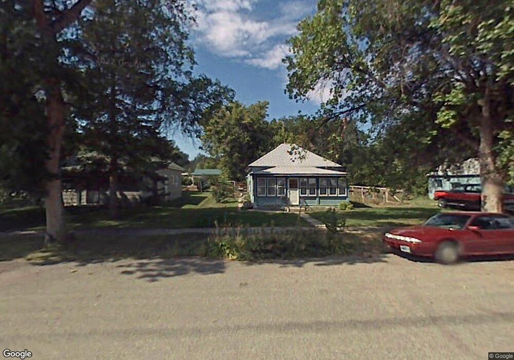
This home is located at 410 S 7th St, Basin, WY 82410 and is currently estimated at $139,969, approximately $170 per square foot. 410 S 7th St is a home with nearby schools including Laura Irwin Elementary School, Riverside High School, and Cloud Peak Middle School.
Ownership History
Date
Name
Owned For
Owner Type
Purchase Details
Closed on
Sep 2, 2020
Sold by
Lindgren Curtis
Bought by
Lindgren Curtis and Lindgren Nicole K
Current Estimated Value
Home Financials for this Owner
Home Financials are based on the most recent Mortgage that was taken out on this home.
Original Mortgage
$53,350
Outstanding Balance
$47,257
Interest Rate
2.8%
Mortgage Type
New Conventional
Estimated Equity
$92,712
Purchase Details
Closed on
Jun 25, 2018
Sold by
Mead Larry A and Mead Therese J
Bought by
Lindgren Curtis
Home Financials for this Owner
Home Financials are based on the most recent Mortgage that was taken out on this home.
Original Mortgage
$51,000
Interest Rate
4.6%
Mortgage Type
Unknown
Create a Home Valuation Report for This Property
The Home Valuation Report is an in-depth analysis detailing your home's value as well as a comparison with similar homes in the area
Home Values in the Area
Average Home Value in this Area
Purchase History
| Date | Buyer | Sale Price | Title Company |
|---|---|---|---|
| Lindgren Curtis | -- | None Available | |
| Lindgren Curtis | -- | -- |
Source: Public Records
Mortgage History
| Date | Status | Borrower | Loan Amount |
|---|---|---|---|
| Open | Lindgren Curtis | $53,350 | |
| Previous Owner | Lindgren Curtis | $51,000 |
Source: Public Records
Tax History Compared to Growth
Tax History
| Year | Tax Paid | Tax Assessment Tax Assessment Total Assessment is a certain percentage of the fair market value that is determined by local assessors to be the total taxable value of land and additions on the property. | Land | Improvement |
|---|---|---|---|---|
| 2025 | $668 | $6,637 | $1,418 | $5,219 |
| 2024 | $668 | $8,562 | $1,871 | $6,691 |
| 2023 | $759 | $9,734 | $3,301 | $6,433 |
| 2022 | $612 | $7,850 | $1,876 | $5,974 |
| 2021 | $534 | $7,029 | $1,876 | $5,153 |
| 2020 | $578 | $7,599 | $2,138 | $5,461 |
| 2019 | $558 | $7,345 | $2,090 | $5,255 |
| 2018 | $427 | $5,618 | $1,758 | $3,860 |
| 2017 | $425 | $5,596 | $1,861 | $3,735 |
| 2016 | $424 | $5,478 | $0 | $0 |
| 2015 | -- | $5,471 | $0 | $0 |
| 2014 | -- | $5,319 | $0 | $0 |
| 2013 | -- | $5,206 | $1,812 | $3,394 |
Source: Public Records
Map
Nearby Homes
- 601 S 8th St
- 602 S 6th St
- 719 W B St
- 618 Montana Ave
- 905 S 9th St
- 415 Holdrege Ave
- W Bighorn Ave W
- Tbd Big Horn Ave
- TBD Bighorn Ave W
- 854 U S 20
- 310 North St
- 2834 Lane 42
- 4127 Golf Course Rd
- TBD Hwy 20 Hwy S
- 2303 Lane 40
- 1242 Us Highway 20 S
- 2303 Ln 40
- 1242 U S 20
- 2644 Lane 36 1 2
- 0 Tbd Highway 20 S Unit LotWP004