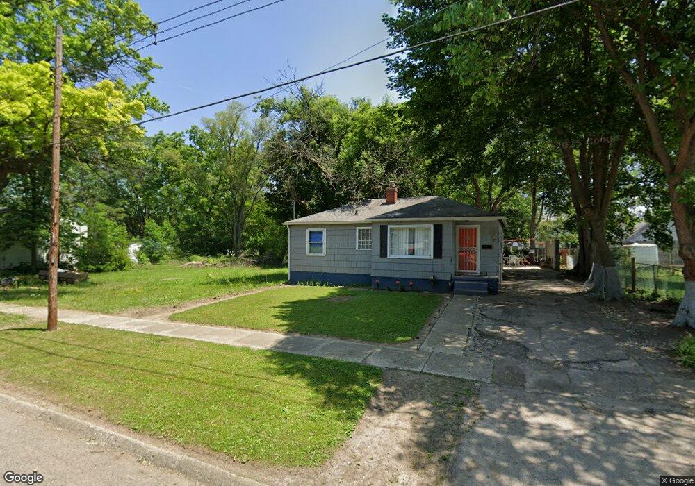
4102 Proctor Ave Flint, MI 48504
Sterling and Myrtle NeighborhoodEstimated Value: $30,000 - $60,376
3
Beds
1
Bath
848
Sq Ft
$59/Sq Ft
Est. Value
About This Home
This home is located at 4102 Proctor Ave, Flint, MI 48504 and is currently estimated at $50,094, approximately $59 per square foot. 4102 Proctor Ave is a home located in Genesee County with nearby schools including Brownell STEM Academy, The New Standard Academy, and Eagle's Nest Academy.
Ownership History
Date
Name
Owned For
Owner Type
Purchase Details
Closed on
May 29, 2024
Sold by
Genesee Cnty Land Bk Authority
Bought by
Rodriguez Leonor
Current Estimated Value
Purchase Details
Closed on
Dec 20, 2017
Sold by
Cherly Deborah L
Bought by
Genessee County Land Bank Authority
Purchase Details
Closed on
Oct 3, 1983
Sold by
Taylor Dolores and Taylor Dolores M
Bought by
Sims Pauline
Home Financials for this Owner
Home Financials are based on the most recent Mortgage that was taken out on this home.
Original Mortgage
$17,500
Interest Rate
11%
Mortgage Type
Seller Take Back
Create a Home Valuation Report for This Property
The Home Valuation Report is an in-depth analysis detailing your home's value as well as a comparison with similar homes in the area
Home Values in the Area
Average Home Value in this Area
Purchase History
| Date | Buyer | Sale Price | Title Company |
|---|---|---|---|
| Rodriguez Leonor | $2,900 | None Listed On Document | |
| Genessee County Land Bank Authority | -- | None Available | |
| Sims Pauline | $19,500 | Transamerica Title Services |
Source: Public Records
Mortgage History
| Date | Status | Borrower | Loan Amount |
|---|---|---|---|
| Previous Owner | Sims Pauline | $17,500 |
Source: Public Records
Tax History
| Year | Tax Paid | Tax Assessment Tax Assessment Total Assessment is a certain percentage of the fair market value that is determined by local assessors to be the total taxable value of land and additions on the property. | Land | Improvement |
|---|---|---|---|---|
| 2025 | $265 | $9,200 | $0 | $0 |
| 2024 | $265 | $0 | $0 | $0 |
| 2023 | -- | $0 | $0 | $0 |
| 2022 | $0 | $0 | $0 | $0 |
| 2021 | $0 | $0 | $0 | $0 |
| 2020 | $0 | $0 | $0 | $0 |
| 2019 | $688 | $0 | $0 | $0 |
| 2018 | $221 | $0 | $0 | $0 |
| 2017 | $1,359 | $0 | $0 | $0 |
| 2016 | $688 | $0 | $0 | $0 |
| 2015 | -- | $0 | $0 | $0 |
| 2014 | -- | $0 | $0 | $0 |
| 2012 | -- | $12,200 | $0 | $0 |
Source: Public Records
Map
Nearby Homes
- 3802 Milbourne Ave
- 1315 W Myrtle Ave
- 4306 Berger Dr
- 3722 Sterling St
- 606 W Stewart Ave
- 3422 Race St
- 3420 Fleming Rd
- 702/718 W Flint Park Blvd
- 3808 Comstock Ave
- 4539 Trumbull Dr
- 3207 Milbourne Ave
- 3517 Leerda St
- 3505 Leerda St
- 4808 Edwards Ave
- 3221 Burgess St
- 3419 Leerda St
- 3413 Leerda St
- 3218 Trumbull Ave
- 3506 Brownell Blvd
- 4702 Warrington Dr
- 4034 Proctor Ave
- 4030 Proctor Ave
- 4026 Proctor Ave
- 4110 Proctor Ave
- 4106 Proctor Ave
- 4029 Milbourne Ave
- 4022 Proctor Ave
- 4101 Proctor Ave
- 4025 Milbourne Ave
- 4033 Milbourne Ave
- 4101 Milbourne Ave
- 4029 Proctor Ave
- 4033 Proctor Ave
- 4105 Milbourne Ave
- 4025 Proctor Ave
- 4021 Milbourne Ave
- 4018 Proctor Ave
- 4021 Proctor Ave
- 4114 Proctor Ave
- 4105 Proctor Ave
Your Personal Tour Guide
Ask me questions while you tour the home.