Estimated Value: $81,466
Studio
--
Bath
1,120
Sq Ft
$73/Sq Ft
Est. Value
About This Home
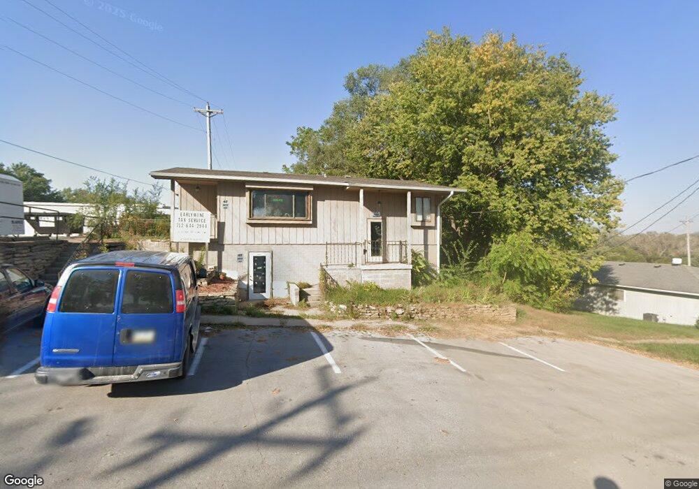
This home is located at 411 E 6th St, Logan, IA 51546 and is currently estimated at $81,466, approximately $72 per square foot. 411 E 6th St is a home located in Harrison County with nearby schools including Logan-Magnolia Elementary School and Logan-Magnolia Junior/Senior High School.
Ownership History
Date
Name
Owned For
Owner Type
Purchase Details
Closed on
Jul 22, 2021
Sold by
Nickerson Daniel A and Nickerson Anita
Bought by
Earlywine Kris
Current Estimated Value
Purchase Details
Closed on
Sep 10, 2018
Sold by
Nickerson Daniel A and Nickolson Anita
Bought by
Earlywine Kris
Purchase Details
Closed on
Jul 29, 2009
Sold by
Oviatt Denise L and Oviatt Rodney G
Bought by
Nickerson Daniel A and Nickerson Tammy L
Home Financials for this Owner
Home Financials are based on the most recent Mortgage that was taken out on this home.
Original Mortgage
$45,883
Interest Rate
4.19%
Mortgage Type
Future Advance Clause Open End Mortgage
Create a Home Valuation Report for This Property
The Home Valuation Report is an in-depth analysis detailing your home's value as well as a comparison with similar homes in the area
Purchase History
| Date | Buyer | Sale Price | Title Company |
|---|---|---|---|
| Earlywine Kris | $65,000 | None Available | |
| Earlywine Kris | $65,000 | -- | |
| Nickerson Daniel A | $65,000 | None Available |
Source: Public Records
Mortgage History
| Date | Status | Borrower | Loan Amount |
|---|---|---|---|
| Previous Owner | Nickerson Daniel A | $45,883 |
Source: Public Records
Tax History
| Year | Tax Paid | Tax Assessment Tax Assessment Total Assessment is a certain percentage of the fair market value that is determined by local assessors to be the total taxable value of land and additions on the property. | Land | Improvement |
|---|---|---|---|---|
| 2025 | $1,452 | $90,830 | $3,660 | $87,170 |
| 2024 | $1,452 | $82,660 | $3,660 | $79,000 |
| 2023 | $1,402 | $82,660 | $3,660 | $79,000 |
| 2022 | $2,128 | $65,608 | $3,656 | $61,952 |
| 2021 | $2,128 | $65,608 | $3,656 | $61,952 |
| 2020 | $2,032 | $65,608 | $3,656 | $61,952 |
| 2019 | $2,630 | $65,608 | $3,656 | $61,952 |
| 2018 | $2,636 | $83,011 | $0 | $0 |
| 2017 | $2,640 | $83,011 | $0 | $0 |
| 2016 | $2,762 | $83,011 | $0 | $0 |
| 2015 | $2,762 | $60,153 | $0 | $0 |
| 2014 | $2,114 | $60,153 | $0 | $0 |
Source: Public Records
Map
Nearby Homes
- 217 N 2nd Ave
- 114 E 10th St
- 1010 Skyline Dr
- Lot 18 Mulligan Trail
- 2144 Norton Ave
- LOT 27 Mulligan Trail
- LOT 26 Lmvcc Estates
- 2464 Mulligan Trail
- LOT 20 Lmvcc Estates
- LOT 17 Lmvcc Estates
- LOT 15 Mulligan Trail
- 2853 Preston Place
- 0 Preston Place
- 0 Preston Place 2 Parcels
- LOTS 5 & 6 Fieldcrest Dr
- LOT D Fieldcrest Dr
- LOT 9 & 10 Fieldcrest Dr
- LOT E & K Fieldcrest Dr
- LOT C Fieldcrest Dr
- LOTS 7 & 8 Fieldcrest Dr
Your Personal Tour Guide
Ask me questions while you tour the home.