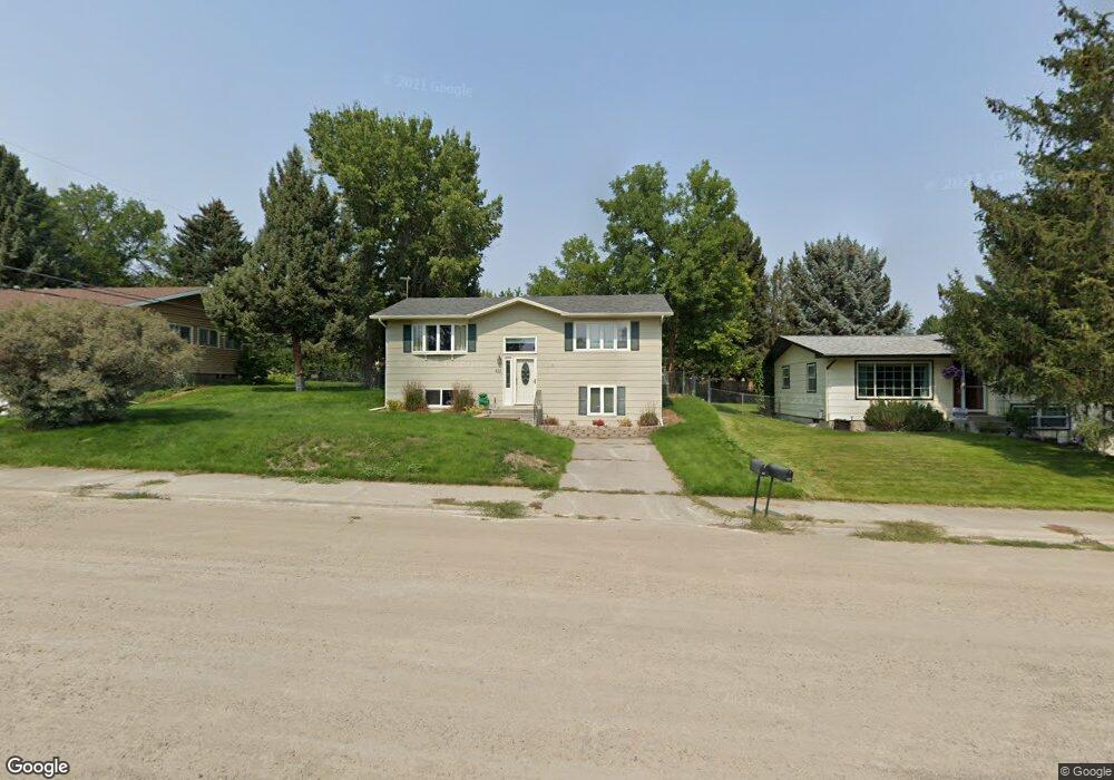
411 W 11th St Laurel, MT 59044
Estimated Value: $316,000 - $347,000
3
Beds
2
Baths
1,824
Sq Ft
$181/Sq Ft
Est. Value
About This Home
This home is located at 411 W 11th St, Laurel, MT 59044 and is currently estimated at $329,765, approximately $180 per square foot. 411 W 11th St is a home located in Yellowstone County with nearby schools including West School, Fred W. Graff School, and Laurel Middle School.
Ownership History
Date
Name
Owned For
Owner Type
Purchase Details
Closed on
Jun 4, 2024
Sold by
Sapone Sean J and Gallant Tiffini N
Bought by
Jackson Mary J and Jackson Allison
Current Estimated Value
Purchase Details
Closed on
Apr 12, 2021
Sold by
George Joshua E and George Lindsay B
Bought by
Sapone Sean J and Sapone Tiffini N
Home Financials for this Owner
Home Financials are based on the most recent Mortgage that was taken out on this home.
Original Mortgage
$273,484
Interest Rate
2.9%
Mortgage Type
USDA
Purchase Details
Closed on
Jun 11, 2007
Sold by
Strecker Michael A
Bought by
George Joshua E and George Lindsay B
Home Financials for this Owner
Home Financials are based on the most recent Mortgage that was taken out on this home.
Original Mortgage
$166,358
Interest Rate
6.14%
Mortgage Type
FHA
Create a Home Valuation Report for This Property
The Home Valuation Report is an in-depth analysis detailing your home's value as well as a comparison with similar homes in the area
Home Values in the Area
Average Home Value in this Area
Purchase History
| Date | Buyer | Sale Price | Title Company |
|---|---|---|---|
| Jackson Mary J | -- | First Montana Title | |
| Sapone Sean J | -- | Chicago Title | |
| George Joshua E | -- | Chicago Title Insurance Co |
Source: Public Records
Mortgage History
| Date | Status | Borrower | Loan Amount |
|---|---|---|---|
| Previous Owner | Sapone Sean J | $273,484 | |
| Previous Owner | George Joshua E | $166,358 |
Source: Public Records
Tax History
| Year | Tax Paid | Tax Assessment Tax Assessment Total Assessment is a certain percentage of the fair market value that is determined by local assessors to be the total taxable value of land and additions on the property. | Land | Improvement |
|---|---|---|---|---|
| 2025 | $2,632 | $322,200 | $59,594 | $262,606 |
| 2024 | $2,632 | $266,600 | $38,779 | $227,821 |
| 2023 | $2,428 | $266,600 | $38,779 | $227,821 |
| 2022 | $2,193 | $228,600 | $0 | $0 |
| 2021 | $2,211 | $228,600 | $0 | $0 |
| 2020 | $2,011 | $204,900 | $0 | $0 |
| 2019 | $2,018 | $204,900 | $0 | $0 |
| 2018 | $1,830 | $174,300 | $0 | $0 |
| 2017 | $1,484 | $174,300 | $0 | $0 |
| 2016 | $1,679 | $174,100 | $0 | $0 |
| 2015 | $1,659 | $174,100 | $0 | $0 |
| 2014 | $1,483 | $80,719 | $0 | $0 |
Source: Public Records
Map
Nearby Homes
- 1216 W 12th Street Cir
- 1254 W Beartooth Dr
- 1109 10th Ave
- 1319 Valley Dr
- 1013 W 12th St
- 603 5th Ave
- 319 6th Ave
- 110 E 5th St
- 516 Pennsylvania Ave
- 1631 Valley Dr
- 310 (and 814 w 4) 8th Ave
- 1014 Rochelle Ln
- TBD Block 3 Lot 6
- 414 Wyoming Ave
- 116 4th Ave
- 601 E 5th St
- 102 8th Ave Unit B
- 1735 Lobo Dr
- 717 E 5th St
- 717 E 5th, 506 Alder Ave
Your Personal Tour Guide
Ask me questions while you tour the home.