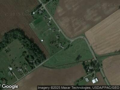
4110 State Route 559 North Lewisburg, OH 43060
Estimated Value: $346,485 - $383,000
3
Beds
2
Baths
1,824
Sq Ft
$202/Sq Ft
Est. Value
About This Home
This home is located at 4110 State Route 559, North Lewisburg, OH 43060 and is currently estimated at $368,121, approximately $201 per square foot. 4110 State Route 559 is a home located in Champaign County with nearby schools including Triad Elementary School, Triad Middle School, and Triad High School.
Ownership History
Date
Name
Owned For
Owner Type
Purchase Details
Closed on
Nov 25, 2014
Sold by
Atherton Terry L and Atherton Merry T
Bought by
Hardy Joshua A and Thomas Dayna M
Current Estimated Value
Home Financials for this Owner
Home Financials are based on the most recent Mortgage that was taken out on this home.
Original Mortgage
$184,594
Interest Rate
3.87%
Mortgage Type
FHA
Purchase Details
Closed on
Mar 31, 2008
Sold by
Orr Michael and Orr Kathy
Bought by
Atherton Terry L and Atherton Merry T
Home Financials for this Owner
Home Financials are based on the most recent Mortgage that was taken out on this home.
Original Mortgage
$152,000
Interest Rate
5.79%
Mortgage Type
New Conventional
Purchase Details
Closed on
Aug 12, 2004
Sold by
Orr Kathy
Bought by
Orr Michael
Home Financials for this Owner
Home Financials are based on the most recent Mortgage that was taken out on this home.
Original Mortgage
$122,500
Interest Rate
6.1%
Mortgage Type
Stand Alone Refi Refinance Of Original Loan
Create a Home Valuation Report for This Property
The Home Valuation Report is an in-depth analysis detailing your home's value as well as a comparison with similar homes in the area
Home Values in the Area
Average Home Value in this Area
Purchase History
| Date | Buyer | Sale Price | Title Company |
|---|---|---|---|
| Hardy Joshua A | $188,000 | None Available | |
| Atherton Terry L | $95,000 | Attorney | |
| Orr Michael | -- | -- |
Source: Public Records
Mortgage History
| Date | Status | Borrower | Loan Amount |
|---|---|---|---|
| Closed | Hardy Joshua A | $173,000 | |
| Closed | Hardy Joshua A | $184,594 | |
| Closed | Atherton Terry L | $152,000 | |
| Closed | Orr Michael | $122,500 |
Source: Public Records
Tax History Compared to Growth
Tax History
| Year | Tax Paid | Tax Assessment Tax Assessment Total Assessment is a certain percentage of the fair market value that is determined by local assessors to be the total taxable value of land and additions on the property. | Land | Improvement |
|---|---|---|---|---|
| 2024 | $3,366 | $88,820 | $8,840 | $79,980 |
| 2023 | $3,366 | $88,820 | $8,840 | $79,980 |
| 2022 | $3,363 | $88,820 | $8,840 | $79,980 |
| 2021 | $2,892 | $71,050 | $7,070 | $63,980 |
| 2020 | $2,893 | $71,050 | $7,070 | $63,980 |
| 2019 | $2,846 | $71,050 | $7,070 | $63,980 |
| 2018 | $2,574 | $65,590 | $6,720 | $58,870 |
| 2017 | $2,516 | $65,590 | $6,720 | $58,870 |
| 2016 | $2,501 | $65,590 | $6,720 | $58,870 |
| 2015 | $2,280 | $60,240 | $6,720 | $53,520 |
| 2014 | $2,286 | $61,200 | $7,680 | $53,520 |
| 2013 | $2,267 | $61,200 | $7,680 | $53,520 |
Source: Public Records
Map
Nearby Homes
- 0 Berton Rd Unit 5081133
- 35 Weldon Ln
- 215 N Main St
- 40 Dooley Dr
- 20 Lloyd Dr
- 273 Mill St
- 300 Mill St
- 701 Mill St Unit Lot 49
- 701 Mill St Unit Lot 12
- 701 Mill St Unit 90
- 701 Mill St Unit Lot 129
- 701 Mill St Unit Lot 78
- 701 Mill St Unit Lot 48
- 701 Mill St Unit Lot 88
- 701 Mill St Unit Lot 170
- 701 Mill St Unit Lot 106
- 701 Mill St Unit 5
- 254 E Bennett St
- 258 E Bennett St
- 0 Lincoln Place Unit Lot 1 906429
- 4110 State Route 559
- 4110 Ohio 559
- 4154 State Route 559
- 4154 Ohio 559
- 4162 State Route 559
- 4162 Ohio 559
- 4190 State Route 559
- 4212 State Route 559
- 4155 Glendinning Rd
- 4212 Ohio 559
- 4165 Glendinning Rd
- 4236 Ohio 559
- 4236 State Route 559
- 4177 Glendinning Rd
- 4189 Glendinning Rd
- 4309 State Route 559
- 4209 Glendinning Rd
- 4235 Glendenning Rd
- 4289 State Route 559
- 4249 State Route 559
