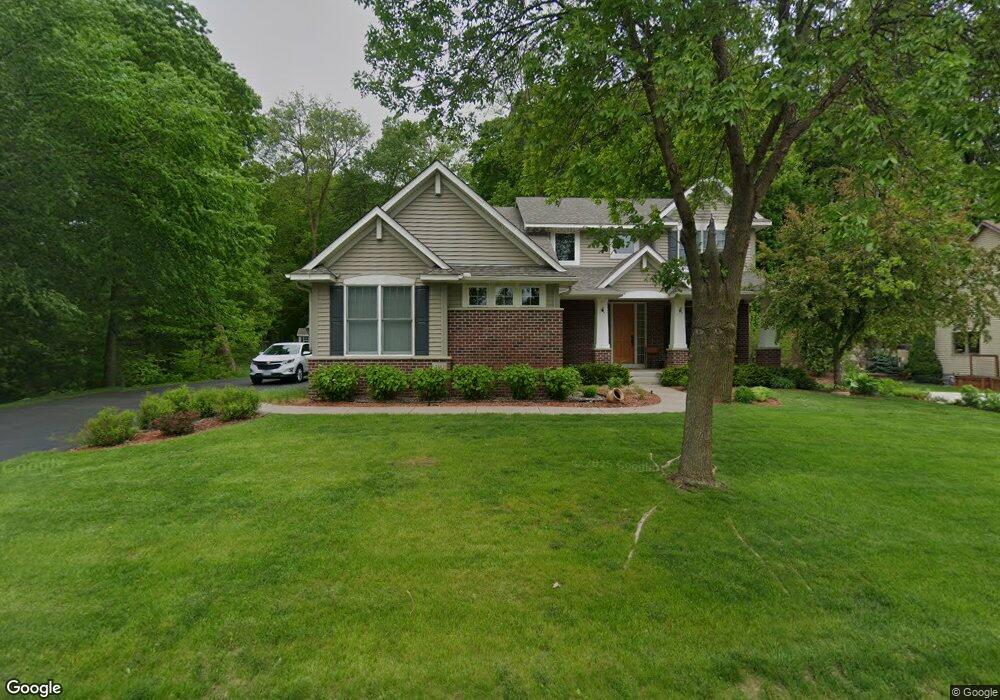
4111 Maple Hurst Dr S Rockford, MN 55373
Estimated Value: $548,211 - $598,000
4
Beds
3
Baths
2,732
Sq Ft
$210/Sq Ft
Est. Value
About This Home
This home is located at 4111 Maple Hurst Dr S, Rockford, MN 55373 and is currently estimated at $573,053, approximately $209 per square foot. 4111 Maple Hurst Dr S is a home located in Wright County with nearby schools including Rockford Elementary Arts Magnet School, Rockford Middle School - Center for Environmental Studies, and Rockford High School.
Ownership History
Date
Name
Owned For
Owner Type
Purchase Details
Closed on
Mar 30, 2016
Sold by
Dail Brian and Dail Tirza
Bought by
Place Jesse Lee and Place Courtney
Current Estimated Value
Purchase Details
Closed on
Feb 15, 2005
Sold by
Darrel A Farr Development Corp
Bought by
Lundgren Bros Construction Inc
Create a Home Valuation Report for This Property
The Home Valuation Report is an in-depth analysis detailing your home's value as well as a comparison with similar homes in the area
Home Values in the Area
Average Home Value in this Area
Purchase History
| Date | Buyer | Sale Price | Title Company |
|---|---|---|---|
| Place Jesse Lee | $378,000 | Title Choice Llc | |
| Lundgren Bros Construction Inc | $260,000 | -- |
Source: Public Records
Tax History Compared to Growth
Tax History
| Year | Tax Paid | Tax Assessment Tax Assessment Total Assessment is a certain percentage of the fair market value that is determined by local assessors to be the total taxable value of land and additions on the property. | Land | Improvement |
|---|---|---|---|---|
| 2025 | $5,526 | $507,800 | $90,000 | $417,800 |
| 2024 | $5,394 | $477,400 | $90,000 | $387,400 |
| 2023 | $5,526 | $478,200 | $90,000 | $388,200 |
| 2022 | $5,472 | $437,100 | $85,000 | $352,100 |
| 2021 | $5,562 | $386,000 | $70,000 | $316,000 |
| 2020 | $5,712 | $383,800 | $70,000 | $313,800 |
| 2019 | $5,870 | $370,700 | $0 | $0 |
| 2018 | $5,082 | $363,400 | $0 | $0 |
| 2017 | $4,814 | $337,700 | $0 | $0 |
| 2016 | $4,680 | $0 | $0 | $0 |
| 2015 | $4,614 | $0 | $0 | $0 |
| 2014 | -- | $0 | $0 | $0 |
Source: Public Records
Map
Nearby Homes
- 4090 Maple Hurst Dr S
- 4040 Maple Hurst Dr S
- 4231 Maple Hurst Dr N
- XXX Jansen Ave SE
- 6761 Maple Dr
- 7021 Meadow Ct
- 6630 Maple Dr
- 8130 Ravenrock Rd
- 8530 Fir St
- 8041 Prairie Trail
- 7040 Winfield Rd
- 3439 Hall Ave SE
- 8800 86th Ave N
- 8098 26th St SE
- 6101 Boulder Ridge Dr
- 8833 Walnut Place
- 7175 Sterling Dr
- The Madison Plan at Kettering Creek - Kettering Creek Villas
- The Windsor Villa Plan at Kettering Creek - Kettering Creek Villas
- The Windsor Plan at Kettering Creek - Kettering Creek Villas
- 4111 4111 Maple Hurst-Drive-s
- 4121 Maple Hurst Dr S
- 4121 4121 Maple Hurst Dr S
- 4251 Maple Hurst Dr S
- 4081 Maple Hurst Dr S
- 4071 4071 Maple Hurst Dr S
- 4071 Maple Hurst Dr S
- 3013 3013 Red Maple-Court-n
- 3013 Red Maple Ct
- 3013 Red Maple Ct
- 3013 Red Maple Ct
- 4110 Maple Hurst Dr S
- 4061 4061 Maple Hurst-Drive-s
- 4061 4061 Maple Hurst Dr S
- 4120 Maple Hurst Dr S
- 4120 4120 Maple Hurst Dr S
- 4120 4120 Maple Hurst-Drive-s
- 3015 3015 Red Maple Ct N
- 3015 Red Maple Ct
- 4100 Maple Hurst Dr S