NOT LISTED FOR SALE

4112 Officers Chapel Rd Cookeville, TN 38506

Estimated Value: $381,000 - $1,129,972

11.67 Acres
$66,495 Price per Acre
508,345 Sq Ft Lot

Last Sold May 31, 2012

Last sale price $107,000

Est. 625% increase in value since last sale

Current estimated payment $4,388/month

Highlights

  • Home fronts a pond
  • 11.67 Acre Lot
  • Level Lot
  • Algood Elementary School Rated A-
  • No HOA

About This Lot

As of May 2012

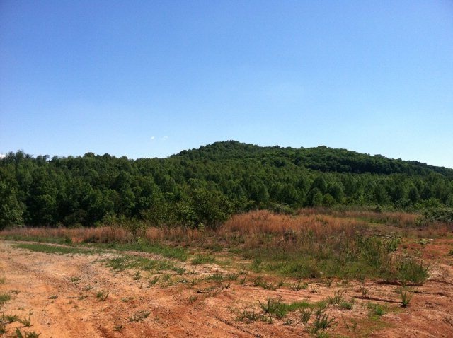
Make this the site for you beautiful new home! Stunning views on 11.7 acres, small road front pond, ready to build land, close to town, and a very motivated seller!! ONLY $139,900

Last Agent to Sell the Property

Seanaree Albrecht

First Realty Company Brokerage Phone: 9315281573 License #324419 Listed on: 04/19/2012

Last Buyer's Agent

Seanaree Albrecht

First Realty Company Brokerage Phone: 9315281573 License #324419 Listed on: 04/19/2012

Property Details

Property Type

  • Land

Est. Annual Taxes

  • $545

Lot Details

  • 11.67 Acre Lot
  • Home fronts a pond
  • Level Lot

Utilities

  • Septic Tank

Community Details

  • No Home Owners Association

Listing and Financial Details

  • Assessor Parcel Number 043.00

Property Details

Property Type

Land

Est. Annual Taxes

$545

Lot Details

0

Listing Details

  • Attribution Contact: 9315281573
  • Directions: FROM PCCH: EAST ON SPRING, LEFT ON HWY 111 N, LEFT ON OFFICERS CHAPEL, PROPERTY ON RIGHT WITH SIGN.
  • Prop. Type: Land
  • Property Sub Type: Single Family Lot
  • Lot Size Acres: 11.67
  • Lot Size: 11.67 AC
  • Road Surface Type: Paved
  • Subdivision Name: None
  • Special Features: None

Exterior Features

  • Topography: Level,Rolling
  • Waterfront Features: Pond

Utilities

  • Electric: UCEMC
  • Sewer: Septic Tank
  • Gas Company: NA
  • Electricity On Property: Yes
  • Utilities: Electricity Available
  • Water Source: Public, TBD

Condo/Co-op/Association

  • Association: No

Lot Info

  • Lot Size Sq Ft: 508345.2
  • Farm Land Area Units: Square Feet
  • Wooded Area: 29185.2
  • Parcel #: 043.00
  • Irrigation Water Rights: No

Tax Info

  • Tax Annual Amount: 544.89
  • Tax Map Number: 20

Ownership History

Date Name Owned For Owner Type

Purchase Details

Closed on
Feb 21, 2019
Sold by
Goolsby Mildred Christine Estate
Bought by
Greer Jerry Randall
Current Estimated Value
$775,991

Purchase Details

Listed on
Apr 19, 2012
Closed on
May 31, 2012
Sold by
Mccloud Dalene M
Bought by
Greer Jerry Randall
Seller's Agent
Seanaree Albrecht
First Realty Company
Buyer's Agent
Seanaree Albrecht
First Realty Company
Sold Price
$107,000

Home Financials for this Owner

Home Financials are based on the most recent Mortgage that was taken out on this home.
Avg. Annual Appreciation
15.82%

Purchase Details

Closed on
Mar 5, 2012
Sold by
Mccloud Michael R
Bought by
Mccloud Dalene M

Purchase Details

Closed on
Mar 2, 2012
Sold by
Mccloud Dalene
Bought by
Mccloud Mike

Purchase Details

Closed on
Nov 28, 2007
Sold by
Mcdonald Richard L
Bought by
Mccloud Michael R

Purchase Details

Closed on
Nov 24, 1998
Sold by
Goolsby James B
Bought by
Mcdonald and Janice

Purchase Details

Closed on
Feb 10, 1997
Sold by
Goolsby James B
Bought by
Peek Jimmy L

Purchase Details

Closed on
Feb 17, 1955
Bought by
Goolsby James B
Source: Public Records

Range of Values:

--
Value Increase
--
Percent Increase
--
Adjusted for Inflation
Collateral Analytics

Collateral Analytics Collateral Analytics AVMs (Automated Valuation Model) employ a number of statistical approaches combined with neighborhood-specific comparable selection guarantees the most up-to-date and precise valuations.

Not Available

Collateral Analytics does not have data for the current month. Please view the chart for historical values.

ICE

ICE Mortgage Technology ICE Mortgage Technology’s AVM (Automated Valuation Model) is a state-of-the-art online residential property valuation tool that provides a quick and accurate estimate of the value of almost any home in the U.S.

Not Available

ICE Mortgage Technology does not have data for the current month. Please view the chart for historical values.

First American

First American First American Data & Analytics’ next-generation AVM combines unrivaled data assets with a blended ensemble of valuation models to produce highly accurate, reliable valuations you can trust.

Not Available

First American does not have data for the current month. Please view the chart for historical values.

Quantarium

Quantarium Quantarium’s valuation service, repeatedly proven the industry’s most accurate and comprehensive, is supercharged with a self-learning and auto-tuning AI engine that continually becomes smarter and more accurate as it processes daily inputs from the industry’s leading RE data lake.

Not Available

Quantarium does not have data for the current month. Please view the chart for historical values.

Average Value
Not Available
List Price
Sold Price
Create a Home Valuation Report for This Property
The Home Valuation Report is an in-depth analysis detailing your home's value as well as a comparison with similar homes in the area

Home Values in the Area

Source: Public Records

Average Home Value in this Area


Source: Public Records

Purchase History

Date Buyer Sale Price Title Company
Greer Jerry Randall $172,200 --
Greer Jerry Randall $107,000 --
Mccloud Dalene M -- --
Mccloud Mike -- --
Mccloud Michael R $150,000 --
Mcdonald $5,550 --
Peek Jimmy L $10,000 --
Goolsby James B -- --
Source: Public Records

Property History

Date Event Price List to Sale Price per Sq Ft
05/31/2012 05/31/12 Sold $107,000 0.0% --
01/01/1970 01/01/70 Off Market $107,000 -- --
Source: Upper Cumberland Association of REALTORS®

Tax History Compared to Growth

Source: Public Records

Tax History

Year Tax Paid Tax Assessment Tax Assessment Total Assessment is a certain percentage of the fair market value that is determined by local assessors to be the total taxable value of land and additions on the property. Land Improvement
2024 $3,475 $130,650 $10,950 $119,700
2023 $3,475 $130,650 $10,950 $119,700
2022 $3,230 $130,650 $10,950 $119,700
2021 $3,230 $130,650 $10,950 $119,700
2020 $3,279 $130,650 $10,950 $119,700
2019 $603 $112,075 $8,750 $103,325
2018 $562 $20,600 $20,600 $0
2017 $562 $20,600 $20,600 $0
2016 $562 $20,600 $20,600 $0
2015 $562 $20,600 $20,600 $0
2014 $578 $20,604 $0 $0
Source: Public Records

Agents Affiliated with this Home

See All Agents

Map

Source: Upper Cumberland Association of REALTORS®

MLS Number: 155962

Upper Cumberland Association of REALTORS®

APN: 020-043.00