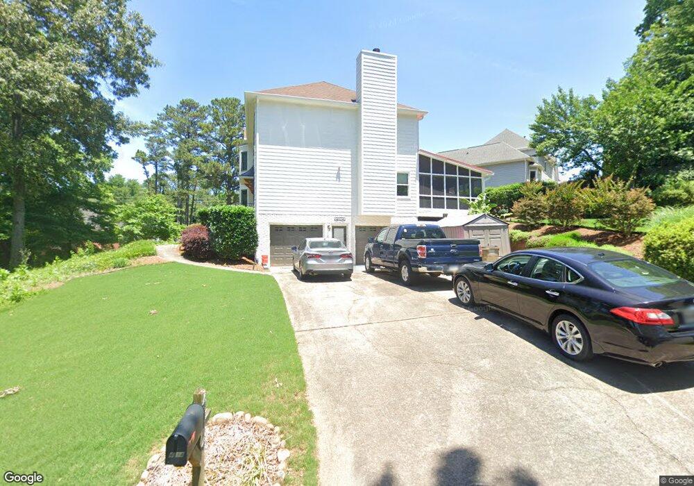
4114 Tanbark Dr NE Unit 1 Marietta, GA 30066
Sandy Plains NeighborhoodEstimated Value: $449,192 - $542,000
4
Beds
3
Baths
2,340
Sq Ft
$208/Sq Ft
Est. Value
About This Home
This home is located at 4114 Tanbark Dr NE Unit 1, Marietta, GA 30066 and is currently estimated at $487,048, approximately $208 per square foot. 4114 Tanbark Dr NE Unit 1 is a home located in Cobb County with nearby schools including Nicholson Elementary School, McCleskey Middle School, and The Garden School.
Ownership History
Date
Name
Owned For
Owner Type
Purchase Details
Closed on
Mar 29, 1994
Sold by
Keary Timothy R
Bought by
Quinn Thonas S Carol
Current Estimated Value
Home Financials for this Owner
Home Financials are based on the most recent Mortgage that was taken out on this home.
Original Mortgage
$119,900
Interest Rate
7.26%
Create a Home Valuation Report for This Property
The Home Valuation Report is an in-depth analysis detailing your home's value as well as a comparison with similar homes in the area
Home Values in the Area
Average Home Value in this Area
Purchase History
| Date | Buyer | Sale Price | Title Company |
|---|---|---|---|
| Quinn Thonas S Carol | $149,900 | -- |
Source: Public Records
Mortgage History
| Date | Status | Borrower | Loan Amount |
|---|---|---|---|
| Closed | Quinn Thonas S Carol | $119,900 |
Source: Public Records
Tax History Compared to Growth
Tax History
| Year | Tax Paid | Tax Assessment Tax Assessment Total Assessment is a certain percentage of the fair market value that is determined by local assessors to be the total taxable value of land and additions on the property. | Land | Improvement |
|---|---|---|---|---|
| 2025 | $961 | $192,444 | $48,000 | $144,444 |
| 2024 | $965 | $192,444 | $48,000 | $144,444 |
| 2023 | $3,197 | $163,080 | $24,000 | $139,080 |
| 2022 | $3,770 | $163,080 | $24,000 | $139,080 |
| 2021 | $3,202 | $137,140 | $24,000 | $113,140 |
| 2020 | $3,100 | $132,468 | $24,000 | $108,468 |
| 2019 | $3,100 | $132,468 | $24,000 | $108,468 |
| 2018 | $2,730 | $115,568 | $18,400 | $97,168 |
| 2017 | $2,416 | $104,336 | $18,400 | $85,936 |
| 2016 | $1,930 | $82,072 | $18,400 | $63,672 |
| 2015 | $1,972 | $82,072 | $18,400 | $63,672 |
| 2014 | $1,985 | $82,072 | $0 | $0 |
Source: Public Records
Map
Nearby Homes
- 1849 Service Dr NE
- 1718 Christie Dr NE
- 1984 Credence Ct NE
- 4181 Keheley Dr NE
- 3844 Havenrock
- 3835 Rockhaven Ct
- 1740 Latour Dr NE
- 3703 Tulip Tree Rd
- 3796 Hickory Ridge Ct
- 4281 Keheley Lake Dr NE
- 3634 Stonehenge Way NE
- 3816 Havenrock Dr
- 3812 Havenrock Dr
- 4056 Longford Dr NE
- 2124 Lassiter Field Dr NE
- 4314 Keheley Lake Ct NE
- 3886 Ebenezer Rd
- 1833 Lake Ebenezer Trail NE
- 1802 Tilliewood Trail NE
- 1805 Sherryl Ct NE
- 4113 Tanbark Dr NE
- 4111 Tanbark Dr NE
- 1803 Tilliewood Trail NE
- 1801 Tilliewood Trail NE
- 1804 Tilliewood Trail NE
- 1805 Tanbark Place NE
- 4109 Tanbark Dr NE
- 4115 Tanbark Dr NE
- 1807 Sherryl Ct NE
- 4118 Tanbark Dr NE
- 1806 Tilliewood Trail NE
- 4152 Brasher Dr NE Unit 1
- 4154 Brasher Dr NE
- 4117 Tanbark Dr NE
- 1807 Tanbark Place NE
- 4107 Tanbark Dr NE Unit 1
- 4108 Tanbark Dr NE
- 4150 Brasher Dr NE