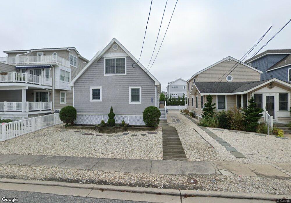
412 21st St Avalon, NJ 08202
Estimated Value: $1,983,825 - $2,408,000
--
Bed
--
Bath
1,728
Sq Ft
$1,238/Sq Ft
Est. Value
About This Home
This home is located at 412 21st St, Avalon, NJ 08202 and is currently estimated at $2,138,456, approximately $1,237 per square foot. 412 21st St is a home located in Cape May County with nearby schools including Avalon Elementary School.
Ownership History
Date
Name
Owned For
Owner Type
Purchase Details
Closed on
Jul 29, 2021
Sold by
Sindaco Michael M and Sindaco Marie A
Bought by
M & Marie Sindaco Ret
Current Estimated Value
Purchase Details
Closed on
Sep 23, 1994
Sold by
Hoy Richard W
Bought by
Sindaco Michael M and Sindaco Marie A
Home Financials for this Owner
Home Financials are based on the most recent Mortgage that was taken out on this home.
Original Mortgage
$116,000
Interest Rate
8.55%
Purchase Details
Closed on
Oct 10, 1992
Sold by
Stewart Patrick H
Bought by
Hoy Richard W
Create a Home Valuation Report for This Property
The Home Valuation Report is an in-depth analysis detailing your home's value as well as a comparison with similar homes in the area
Home Values in the Area
Average Home Value in this Area
Purchase History
| Date | Buyer | Sale Price | Title Company |
|---|---|---|---|
| M & Marie Sindaco Ret | -- | None Available | |
| Michael And Marie Sindaco Revocable Trust | -- | None Listed On Document | |
| Sindaco Michael M | $176,666 | -- | |
| Hoy Richard W | $80,000 | -- |
Source: Public Records
Mortgage History
| Date | Status | Borrower | Loan Amount |
|---|---|---|---|
| Previous Owner | Sindaco Michael M | $116,000 |
Source: Public Records
Tax History Compared to Growth
Tax History
| Year | Tax Paid | Tax Assessment Tax Assessment Total Assessment is a certain percentage of the fair market value that is determined by local assessors to be the total taxable value of land and additions on the property. | Land | Improvement |
|---|---|---|---|---|
| 2025 | $4,083 | $665,000 | $450,000 | $215,000 |
| 2024 | $4,083 | $665,000 | $450,000 | $215,000 |
| 2023 | $4,050 | $665,000 | $450,000 | $215,000 |
| 2022 | $3,777 | $665,000 | $450,000 | $215,000 |
| 2021 | $3,638 | $665,000 | $450,000 | $215,000 |
| 2020 | $3,498 | $665,000 | $450,000 | $215,000 |
| 2019 | $3,392 | $665,000 | $450,000 | $215,000 |
| 2018 | $3,245 | $665,000 | $450,000 | $215,000 |
| 2017 | $3,605 | $648,300 | $450,000 | $198,300 |
| 2016 | $3,566 | $648,300 | $450,000 | $198,300 |
| 2015 | $3,507 | $648,300 | $450,000 | $198,300 |
| 2014 | $3,468 | $648,300 | $450,000 | $198,300 |
Source: Public Records
Map
Nearby Homes
- 440 21st St Unit South (B)
- 890 21st St
- 415 20th St
- 503 20th St
- 389 22nd St
- 431 24th St
- 2425 Harbor Ave Unit 2425
- 647 Barry Rd
- 211 23rd St
- 178 19th St
- 212 25th St
- 212 25th St Unit East Unit
- 174 23rd St
- 161 24th St
- 128 16th St
- 179 27th St
- 279 13th St Unit C-6
- 279 13th St
- 76 21st St W
- 1100 Ocean Dr Unit 312
- 406 21st St
- 406 21st St Unit 406
- 406 21st St Unit west
- 420 21st St
- 404 21st St Unit EAST
- 402 21st St Unit 402
- 402 21st St Unit North
- 432 21st St
- 400 21st St
- 400 21st St Unit South
- 425 22nd St
- 405 21st St
- 440 21st St
- 440 21st St
- 440 21st St Unit Rear (C-B)
- 440 21st St Unit Rear
- 419 22nd St Unit 419
- 429 22nd St
- 429 22nd St
- 429 22nd St Unit East