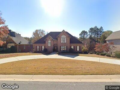
4125 Kesteven Dr Birmingham, AL 35242
North Shelby County NeighborhoodEstimated Value: $632,102 - $675,000
--
Bed
3
Baths
3,521
Sq Ft
$186/Sq Ft
Est. Value
About This Home
This home is located at 4125 Kesteven Dr, Birmingham, AL 35242 and is currently estimated at $654,276, approximately $185 per square foot. 4125 Kesteven Dr is a home located in Shelby County with nearby schools including Inverness Elementary School, Oak Mt. Intermediate School, and Oak Mt. Middle School.
Ownership History
Date
Name
Owned For
Owner Type
Purchase Details
Closed on
Sep 3, 2003
Sold by
Davis Karon Hudson and Hudson Danny G
Bought by
Rj Homes Llc
Current Estimated Value
Purchase Details
Closed on
Jul 1, 2003
Sold by
Davis Karon Hudson and Hudson Danny G
Bought by
Rj Homes Llc
Home Financials for this Owner
Home Financials are based on the most recent Mortgage that was taken out on this home.
Original Mortgage
$200,000
Interest Rate
5.43%
Mortgage Type
Unknown
Create a Home Valuation Report for This Property
The Home Valuation Report is an in-depth analysis detailing your home's value as well as a comparison with similar homes in the area
Home Values in the Area
Average Home Value in this Area
Purchase History
| Date | Buyer | Sale Price | Title Company |
|---|---|---|---|
| Rj Homes Llc | $170,000 | -- | |
| Rj Homes Llc | $170,000 | -- |
Source: Public Records
Mortgage History
| Date | Status | Borrower | Loan Amount |
|---|---|---|---|
| Previous Owner | Brashier Paul W | $200,000 |
Source: Public Records
Tax History Compared to Growth
Tax History
| Year | Tax Paid | Tax Assessment Tax Assessment Total Assessment is a certain percentage of the fair market value that is determined by local assessors to be the total taxable value of land and additions on the property. | Land | Improvement |
|---|---|---|---|---|
| 2024 | $2,000 | $53,720 | $0 | $0 |
| 2023 | $1,916 | $51,480 | $0 | $0 |
| 2022 | $1,804 | $48,500 | $0 | $0 |
| 2021 | $1,622 | $43,640 | $0 | $0 |
| 2020 | $1,507 | $40,580 | $0 | $0 |
| 2019 | $1,566 | $42,160 | $0 | $0 |
| 2017 | $1,566 | $42,160 | $0 | $0 |
| 2015 | $1,493 | $40,200 | $0 | $0 |
| 2014 | $1,456 | $39,220 | $0 | $0 |
Source: Public Records
Map
Nearby Homes
- 4100 Kesteven Dr
- 1604 Wingfield Dr
- 1010 Warrington Cir
- 1027 Williams Trace
- 2985 Brook Highland Dr
- 2080 Brook Highland Ridge
- 4116 Kinross Cir
- 3030 Hampton Cir
- 3213 Brook Highland Trace
- 415 Couples Dr
- 4516 Magnolia Dr
- 4552 Magnolia Dr
- 1030 Chedworth Ct
- 2063 Stone Brook Dr
- 2044 Stone Brook Dr
- 1916 Stone Brook Ln
- 917 Linkside Way
- 1832 Stone Brook Ln
- 1033 Linkside Dr
- 103 Barristers Ct Unit 103
- 4125 Kesteven Dr
- 4121 Kesteven Dr
- 4129 Kesteven Dr
- 4228 Ashington Dr
- 4224 Ashington Dr
- 4232 Ashington Dr
- 4124 Kesteven Dr
- 4117 Kesteven Dr
- 4133 Kesteven Dr
- 4220 Ashington Dr
- 4236 Ashington Dr
- 4128 Kesteven Dr
- 4128 Kesteven Dr
- 4112 Kesteven Dr
- 4113 Kesteven Dr
- 4120 Kesteven Dr
- 4132 Kesteven Dr
- 4137 Kesteven Dr
- 4216 Ashington Dr
- 4240 Ashington Dr