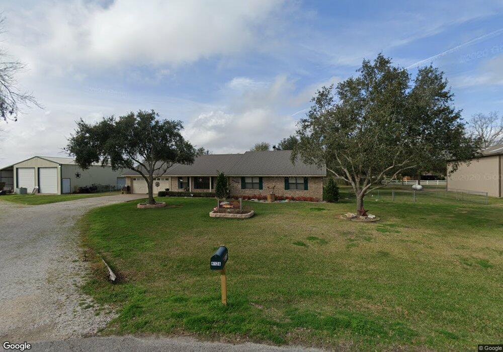
4126 Stephen Cir Rosenberg, TX 77471
Estimated Value: $363,000 - $574,000
3
Beds
2
Baths
2,024
Sq Ft
$213/Sq Ft
Est. Value
About This Home
This home is located at 4126 Stephen Cir, Rosenberg, TX 77471 and is currently estimated at $431,593, approximately $213 per square foot. 4126 Stephen Cir is a home located in Fort Bend County with nearby schools including Beasley Elementary School, Navarro Middle School, and George Junior High School.
Ownership History
Date
Name
Owned For
Owner Type
Purchase Details
Closed on
Jun 29, 2021
Sold by
Bowens Curtis R and Bowens Jasmine I
Bought by
Tsimba Jules Claude Makose Niandu and Wang Yi
Current Estimated Value
Purchase Details
Closed on
Aug 17, 2012
Sold by
Bank Of America Na
Bought by
The Secretary Of Hud
Purchase Details
Closed on
Jun 5, 2012
Sold by
Hernandez Roland and Hernandez Lisette
Bought by
Lnd Management Llc
Purchase Details
Closed on
Jul 25, 1997
Sold by
K & M Home Builders Inc
Bought by
Thumann David C and Thumann Cheryl D
Create a Home Valuation Report for This Property
The Home Valuation Report is an in-depth analysis detailing your home's value as well as a comparison with similar homes in the area
Home Values in the Area
Average Home Value in this Area
Purchase History
| Date | Buyer | Sale Price | Title Company |
|---|---|---|---|
| Tsimba Jules Claude Makose Niandu | -- | None Available | |
| The Secretary Of Hud | -- | None Available | |
| Lnd Management Llc | $68,200 | None Available | |
| Thumann David C | -- | Rosenberg Title Co |
Source: Public Records
Tax History Compared to Growth
Tax History
| Year | Tax Paid | Tax Assessment Tax Assessment Total Assessment is a certain percentage of the fair market value that is determined by local assessors to be the total taxable value of land and additions on the property. | Land | Improvement |
|---|---|---|---|---|
| 2025 | $3,556 | $326,494 | $135,150 | $225,150 |
| 2024 | $3,556 | $296,813 | $62,063 | $234,750 |
| 2023 | $3,169 | $269,830 | $0 | $353,734 |
| 2022 | $3,681 | $245,300 | $0 | $268,050 |
| 2021 | $4,002 | $223,000 | $45,270 | $177,730 |
| 2020 | $4,076 | $223,690 | $45,270 | $178,420 |
| 2019 | $4,209 | $215,410 | $45,270 | $170,140 |
| 2018 | $3,836 | $195,830 | $31,160 | $164,670 |
| 2017 | $3,741 | $190,470 | $31,160 | $159,310 |
| 2016 | $3,814 | $194,190 | $31,160 | $163,030 |
| 2015 | $3,322 | $195,300 | $31,160 | $164,140 |
| 2014 | $3,218 | $191,850 | $31,160 | $160,690 |
Source: Public Records
Map
Nearby Homes
- 00 Hartledge Rd
- 3122 Kueck Rd
- 4333 Sims Rd
- 2607 Finney Vallet Rd
- 00 Kunz Rd
- 0 Kunz Rd
- 0 Cottonwood School Rd
- 506 Twin Ln
- 3330 Band Rd
- 1626 Hartledge Rd
- 2014 Wheat Pasture Way
- 3419 Angus Farm Dr
- 2014 Flower Meadows Dr
- 3402 Angus Farm Dr
- 3402 Angus Farm Rd
- 3323 Hereford Dr
- 1414 Hartledge Rd
- 3330 Hereford Dr
- 3326 Hereford Dr
- 4514 Whisperwood Dr
- 4118 Stephen Cir
- 4127 Scott Cir
- 4119 Scott Cir
- 4127 Stephen Cir
- 4111 Scott Cir
- 4111 Stephen Cir
- 4118 Scott Cir
- 4018 Stephen Cir
- 4019 Scott Cir
- 4110 Scott Cir
- 4018 Scott Cir
- 4011 Scott Cir
- 4011 Stephen Cir
- 4002 Hartledge Rd
- 4005 Scott Cir
- 4003 Stephen Cir
- 4004 Scott Cir
- 2218 Hartledge Rd
- 2428 Hartledge Rd
- 2804 Hartledge Rd