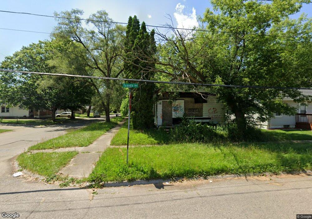
4126 Tuxedo Ave Flint, MI 48507
Westgate NeighborhoodEstimated Value: $67,000 - $85,000
4
Beds
3
Baths
1,932
Sq Ft
$39/Sq Ft
Est. Value
About This Home
This home is located at 4126 Tuxedo Ave, Flint, MI 48507 and is currently estimated at $76,000, approximately $39 per square foot. 4126 Tuxedo Ave is a home located in Genesee County with nearby schools including Neithercut Elementary School, Flint Southwestern Classical Academy, and International Academy of Flint (K-12).
Ownership History
Date
Name
Owned For
Owner Type
Purchase Details
Closed on
Dec 18, 2018
Sold by
Cherry Deborah L
Bought by
Genesee County Land Bank Authority
Current Estimated Value
Purchase Details
Closed on
Oct 30, 2013
Sold by
Colley Carah
Bought by
Ketzbeau Jesse
Purchase Details
Closed on
Apr 18, 2011
Sold by
Colley Edward J and Colley George D
Bought by
Colley Carah I
Purchase Details
Closed on
Aug 25, 2004
Sold by
Damon Sharon L and Boyle Donald E
Bought by
Colley Edward
Purchase Details
Closed on
Mar 1, 2004
Sold by
Boyle Donald E
Bought by
Boyle Donald E and Damon Sharon L
Create a Home Valuation Report for This Property
The Home Valuation Report is an in-depth analysis detailing your home's value as well as a comparison with similar homes in the area
Home Values in the Area
Average Home Value in this Area
Purchase History
| Date | Buyer | Sale Price | Title Company |
|---|---|---|---|
| Genesee County Land Bank Authority | -- | None Available | |
| Ketzbeau Jesse | -- | None Available | |
| Colley Carah I | -- | None Available | |
| Colley Edward | $500 | Lawyers Title Ins | |
| Boyle Donald E | -- | -- |
Source: Public Records
Tax History Compared to Growth
Tax History
| Year | Tax Paid | Tax Assessment Tax Assessment Total Assessment is a certain percentage of the fair market value that is determined by local assessors to be the total taxable value of land and additions on the property. | Land | Improvement |
|---|---|---|---|---|
| 2025 | -- | $0 | $0 | $0 |
| 2024 | -- | $0 | $0 | $0 |
| 2023 | -- | $0 | $0 | $0 |
| 2022 | $0 | $0 | $0 | $0 |
| 2021 | $0 | $0 | $0 | $0 |
| 2020 | $0 | $0 | $0 | $0 |
| 2019 | $1,396 | $0 | $0 | $0 |
| 2018 | $1,465 | $15,200 | $0 | $0 |
| 2017 | $2,154 | $0 | $0 | $0 |
| 2016 | $1,396 | $0 | $0 | $0 |
| 2015 | -- | $0 | $0 | $0 |
| 2014 | -- | $0 | $0 | $0 |
| 2012 | -- | $19,100 | $0 | $0 |
Source: Public Records
Map
Nearby Homes
- 1234 Huron St
- 1310 Huron St
- 1318 Ingleside Ave
- 1329 Huron St
- 1212 Crawford St
- 1314 Pinehurst Ave
- 1031 Ingleside Ave
- 1015 Alvord Ave
- 1416 Blackberry Ln
- 1122 Markham St
- 1228 Leland St
- 1418 Blueberry Ln
- 1039 Markham St
- 1607 Mulberry Ln
- 1028 Campbell St
- 1410 Berrywood Ln
- 1102 W Atherton Rd
- 1826 Greenbrook Ln
- 4418 Brunswick Ave
- 1225 Waldman Ave
- 4122 Tuxedo Ave
- 4118 Tuxedo Ave
- 1201 Alvord Ave
- 1213 Alvord Ave
- 4110 Tuxedo Ave
- 4125 Tuxedo Ave
- 1220 Alvord Ave
- 4117 Tuxedo Ave
- 1221 Alvord Ave
- 1215 Crawford St
- 4102 Tuxedo Ave
- 1125 Alvord Ave
- 4113 Tuxedo Ave
- 1219 Crawford St
- 1230 Alvord Ave
- 1231 Alvord Ave
- 1206 Huron St
- 1202 Huron St
- 1210 Huron St
- 1214 Huron St