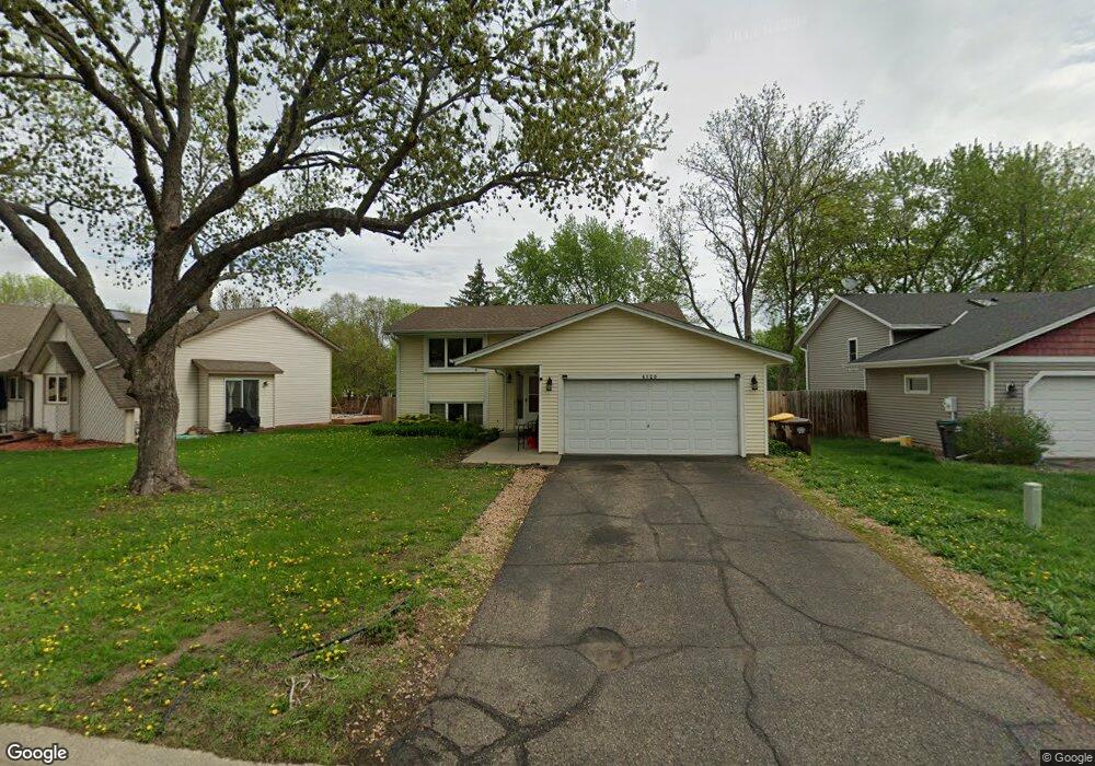
4126 W 131st St Savage, MN 55378
Estimated Value: $366,000 - $392,041
4
Beds
2
Baths
2,032
Sq Ft
$187/Sq Ft
Est. Value
About This Home
This home is located at 4126 W 131st St, Savage, MN 55378 and is currently estimated at $380,760, approximately $187 per square foot. 4126 W 131st St is a home located in Scott County with nearby schools including Hidden Valley Elementary School, Eagle Ridge Middle School, and Burnsville High School.
Ownership History
Date
Name
Owned For
Owner Type
Purchase Details
Closed on
Sep 20, 2019
Sold by
Le Thanh Q
Bought by
Tigre Idalid Aranda
Current Estimated Value
Home Financials for this Owner
Home Financials are based on the most recent Mortgage that was taken out on this home.
Original Mortgage
$275,500
Outstanding Balance
$243,469
Interest Rate
3.5%
Mortgage Type
New Conventional
Estimated Equity
$132,935
Create a Home Valuation Report for This Property
The Home Valuation Report is an in-depth analysis detailing your home's value as well as a comparison with similar homes in the area
Home Values in the Area
Average Home Value in this Area
Purchase History
| Date | Buyer | Sale Price | Title Company |
|---|---|---|---|
| Tigre Idalid Aranda | $290,000 | Title One Inc |
Source: Public Records
Mortgage History
| Date | Status | Borrower | Loan Amount |
|---|---|---|---|
| Open | Tigre Idalid Aranda | $275,500 |
Source: Public Records
Tax History Compared to Growth
Tax History
| Year | Tax Paid | Tax Assessment Tax Assessment Total Assessment is a certain percentage of the fair market value that is determined by local assessors to be the total taxable value of land and additions on the property. | Land | Improvement |
|---|---|---|---|---|
| 2025 | $3,576 | $339,600 | $156,900 | $182,700 |
| 2024 | $3,552 | $335,800 | $151,900 | $183,900 |
| 2023 | $3,666 | $330,800 | $148,900 | $181,900 |
| 2022 | $3,020 | $340,900 | $170,100 | $170,800 |
| 2021 | $3,028 | $271,500 | $132,600 | $138,900 |
| 2020 | $3,022 | $256,400 | $124,100 | $132,300 |
| 2019 | $2,886 | $247,100 | $116,500 | $130,600 |
| 2018 | $2,942 | $0 | $0 | $0 |
| 2016 | $2,782 | $0 | $0 | $0 |
| 2014 | -- | $0 | $0 | $0 |
Source: Public Records
Map
Nearby Homes
- 13016 Glenhurst Ave
- 4318 McColl Dr
- 4430 McColl Dr
- 4525 W 129th St
- 12665 Inglewood Ave S
- 12658 Inglewood Ave S
- 13342 Natchez Ave
- 3220 Harmony Cir
- 12550 Joppa Ave S
- 4008 W 137th St
- 4037 W 124th St
- 2805 Brookview Dr
- 5435 Riverwood Ln
- 5420 Riverwood Ln
- 13734 Inglewood Ave
- 13128 Elm Cir
- 2708 Williams Dr
- 5606 W 132nd St
- 5489 W 134th St
- 4845 W 123rd St Unit 203
- 4144 W 131st St
- 4108 W 131st St
- 4162 W 131st St
- 4090 W 131st St
- 13047 Glenhurst Cir
- 13039 Glenhurst Cir
- 13055 Glenhurst Cir
- 4131 W 131st St
- 4180 W 131st St
- 4072 W 131st St
- 4119 W 131st St
- 13031 Glenhurst Cir
- 4107 W 131st St
- 13063 Glenhurst Cir
- 4093 W 131st St
- 4054 W 131st St
- 4171 W 131st St
- 4079 W 131st St
- 4139 W 131st St
- 13022 Glenhurst Cir