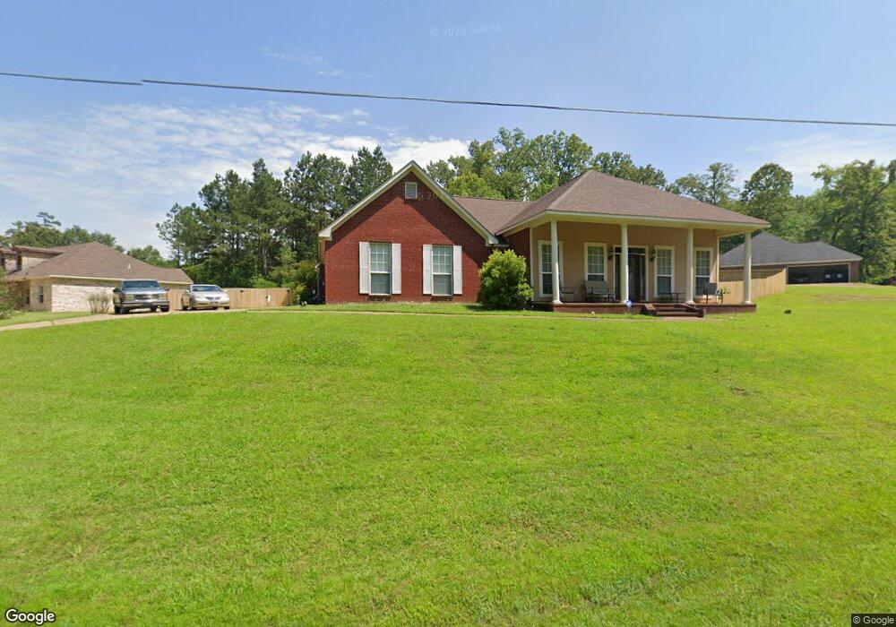
413 Devonport Cir Raymond, MS 39154
Estimated Value: $249,412 - $306,000
3
Beds
2
Baths
1,984
Sq Ft
$138/Sq Ft
Est. Value
About This Home
This home is located at 413 Devonport Cir, Raymond, MS 39154 and is currently estimated at $273,471, approximately $137 per square foot. 413 Devonport Cir is a home located in Hinds County with nearby schools including Gary Road Elementary School, Gary Road Intermediate School, and Byram Middle School.
Ownership History
Date
Name
Owned For
Owner Type
Purchase Details
Closed on
Nov 3, 2009
Sold by
Ponder Ollen Leo
Bought by
Buntley Willie D and Bunley Warxheta
Current Estimated Value
Home Financials for this Owner
Home Financials are based on the most recent Mortgage that was taken out on this home.
Original Mortgage
$122,735
Outstanding Balance
$78,543
Interest Rate
4.93%
Mortgage Type
FHA
Estimated Equity
$194,928
Create a Home Valuation Report for This Property
The Home Valuation Report is an in-depth analysis detailing your home's value as well as a comparison with similar homes in the area
Purchase History
| Date | Buyer | Sale Price | Title Company |
|---|---|---|---|
| Buntley Willie D | -- | -- |
Source: Public Records
Mortgage History
| Date | Status | Borrower | Loan Amount |
|---|---|---|---|
| Open | Buntley Willie D | $122,735 |
Source: Public Records
Tax History
| Year | Tax Paid | Tax Assessment Tax Assessment Total Assessment is a certain percentage of the fair market value that is determined by local assessors to be the total taxable value of land and additions on the property. | Land | Improvement |
|---|---|---|---|---|
| 2025 | $1,491 | $15,160 | $3,000 | $12,160 |
| 2024 | $1,491 | $14,883 | $3,000 | $11,883 |
| 2023 | $1,491 | $14,883 | $3,000 | $11,883 |
| 2022 | $1,752 | $14,883 | $3,000 | $11,883 |
| 2021 | $1,452 | $14,883 | $3,000 | $11,883 |
| 2020 | $1,398 | $14,674 | $3,000 | $11,674 |
| 2019 | $1,388 | $14,674 | $3,000 | $11,674 |
| 2018 | $1,388 | $14,674 | $3,000 | $11,674 |
| 2017 | $1,347 | $14,674 | $3,000 | $11,674 |
| 2016 | $1,347 | $14,674 | $3,000 | $11,674 |
| 2015 | $1,313 | $14,373 | $3,000 | $11,373 |
| 2014 | $1,284 | $14,373 | $3,000 | $11,373 |
Source: Public Records
Map
Nearby Homes
- 106 Sweet Gum Dr
- 133 Wildwood Blvd
- 109 Falcon Ridge Dr
- 120 Wildwood Blvd
- 281 Parks Rd
- 5550 Springridge Rd
- 03 Springridge Rd
- 0000 Big Creek Rd
- 1172 Rockett Dr
- 1408 Dunn Rd
- 00 Dunn Rd
- 7994 Midway Rd
- Oooo Big Creek Rd
- 3521 Mcfarland Rd
- 0 Mcfarland Rd Unit 21460112
- 1132 Lake Mimosa Dr
- 126 Parks Rd
- 107 Davis Road Cove
- 0 Hinds Pkwy
- 2720 Davis Rd
- 420 Devonport Cir
- 416 Devonport Cir
- 105 Haverhill Cove
- 424 Devonport Cir
- 412 Devonport Cir
- 410 Ridge Park Cove
- 421 Devonport Cir
- 409 Ridge Park Cove
- 109 Haverhill Cove
- 405 Devonport Cir
- 108 Haverhill Cove
- 408 Devonport Cir
- 428 Devonport Cir
- 408 Ridge Park Cove
- 407 Ridge Park Cove
- 406 Ridge Park Cove
- 229 Wakeland Dr
- 404 Ridge Park Cove
- 405 Ridge Park Cove
- 402 Ridge Park Cove