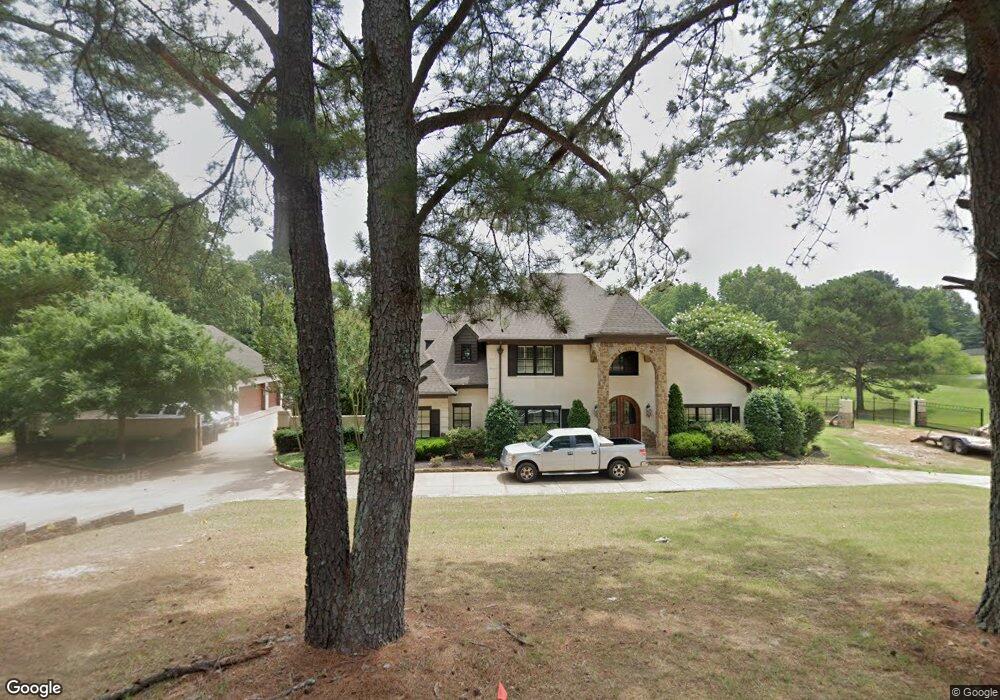
414 Green T Lake W Hernando, MS 38632
Estimated Value: $580,000 - $829,884
4
Beds
5
Baths
4,800
Sq Ft
$143/Sq Ft
Est. Value
About This Home
This home is located at 414 Green T Lake W, Hernando, MS 38632 and is currently estimated at $686,221, approximately $142 per square foot. 414 Green T Lake W is a home located in DeSoto County with nearby schools including Oak Grove Central Elementary School, Hernando Hills Elementary, and Hernando Elementary School.
Ownership History
Date
Name
Owned For
Owner Type
Purchase Details
Closed on
May 8, 2013
Sold by
Bankplus
Bought by
Cookston Peter T and Cookston Melissa D
Current Estimated Value
Purchase Details
Closed on
May 28, 2008
Sold by
Harris Lenard Lee
Bought by
Litwa Richard and Litwa Stacy G
Home Financials for this Owner
Home Financials are based on the most recent Mortgage that was taken out on this home.
Original Mortgage
$285,000
Interest Rate
6.02%
Mortgage Type
Unknown
Create a Home Valuation Report for This Property
The Home Valuation Report is an in-depth analysis detailing your home's value as well as a comparison with similar homes in the area
Home Values in the Area
Average Home Value in this Area
Purchase History
| Date | Buyer | Sale Price | Title Company |
|---|---|---|---|
| Cookston Peter T | -- | None Available | |
| Litwa Richard | -- | None Available |
Source: Public Records
Mortgage History
| Date | Status | Borrower | Loan Amount |
|---|---|---|---|
| Previous Owner | Litwa Richard | $285,000 |
Source: Public Records
Tax History Compared to Growth
Tax History
| Year | Tax Paid | Tax Assessment Tax Assessment Total Assessment is a certain percentage of the fair market value that is determined by local assessors to be the total taxable value of land and additions on the property. | Land | Improvement |
|---|---|---|---|---|
| 2024 | $6,860 | $49,444 | $4,000 | $45,444 |
| 2023 | $6,860 | $49,444 | $0 | $0 |
| 2022 | $6,615 | $47,676 | $4,000 | $43,676 |
| 2021 | $6,615 | $47,676 | $4,000 | $43,676 |
| 2020 | $6,138 | $44,239 | $4,000 | $40,239 |
| 2019 | $5,838 | $44,239 | $4,000 | $40,239 |
| 2017 | $5,487 | $78,994 | $41,497 | $37,497 |
| 2016 | $5,245 | $41,497 | $4,000 | $37,497 |
| 2015 | $5,545 | $78,994 | $41,497 | $37,497 |
| 2014 | $5,413 | $41,497 | $0 | $0 |
| 2013 | -- | $41,497 | $0 | $0 |
Source: Public Records
Map
Nearby Homes
- 457 Fairway Oaks Dr
- 435 Fairway Oaks Dr
- 723 Fairway Trail
- 163 Fairway Trace Dr
- 782 Fairway Trail
- 430 Natchez Loop
- 465 Augusta Dr
- 990 Eagle Ridge Cove
- 833 Martin Cir N
- 208 Elkwood Ln
- 994 Deer Creek Dr
- 617 Doe Creek Trail N
- 5157 U S 51
- 5153 U S 51
- 5163 U S 51
- 5135 U S 51
- 5147 U S 51
- 5167 U S 51
- 5093 U S 51
- 4322 McIngvale Rd
- 414 Green T Lake E
- 360 Green T Lake E
- 431 Green T Lake E
- 415 Country Club Dr
- 375 Country Club Dr
- 320 Green T Lake E
- 455 Country Club Dr
- 460 Bradley Dr
- 0 Country Club Dr
- 548 Bradley Dr
- 351 Green T Lake E
- 611 Green T Lake E
- 295 Green T Lake W
- 325 Country Club Dr
- 345 Green T Rd W
- 277 Green T Rd W
- 272 Green T Lake W
- 62 Green T Lake Rd E
- 370 Country Club Dr
- 610 Bradley Dr