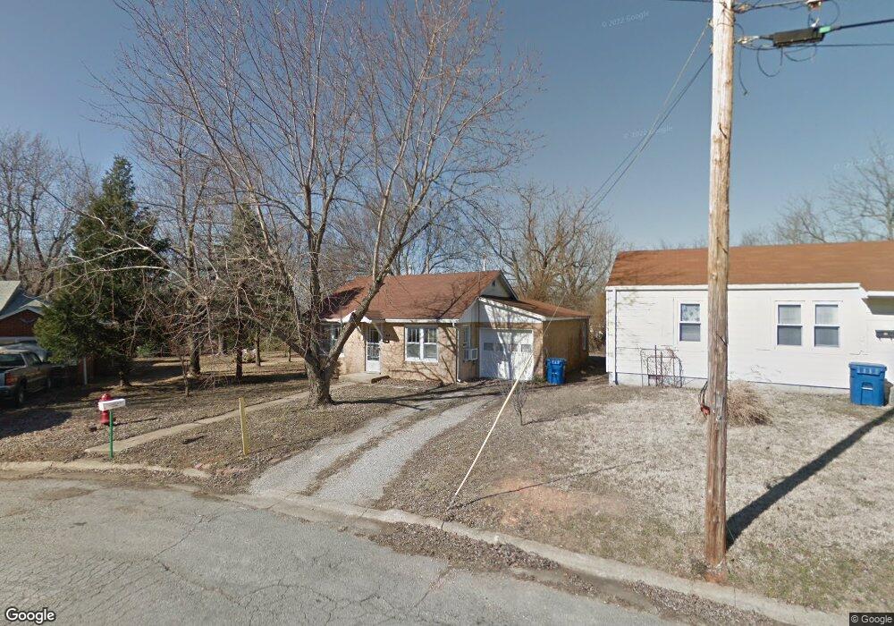
414 Perry St Lebanon, MO 65536
Estimated Value: $98,000 - $114,000
3
Beds
--
Bath
981
Sq Ft
$111/Sq Ft
Est. Value
About This Home
This home is located at 414 Perry St, Lebanon, MO 65536 and is currently estimated at $108,557, approximately $110 per square foot. 414 Perry St is a home located in Laclede County with nearby schools including Joe D. Esther Elementary School, Maplecrest Elementary School, and Boswell Elementary School.
Ownership History
Date
Name
Owned For
Owner Type
Purchase Details
Closed on
Oct 15, 2021
Sold by
Boyer & Boyer Llc
Bought by
Boyer & Boyer Land Company Llc
Current Estimated Value
Home Financials for this Owner
Home Financials are based on the most recent Mortgage that was taken out on this home.
Original Mortgage
$200,000
Outstanding Balance
$182,381
Interest Rate
2.8%
Mortgage Type
Future Advance Clause Open End Mortgage
Estimated Equity
-$73,824
Purchase Details
Closed on
Jul 13, 2021
Sold by
Bollig Gregory C and Bollig Trina K
Bought by
Boyer & Boyer Land Company Llc
Home Financials for this Owner
Home Financials are based on the most recent Mortgage that was taken out on this home.
Original Mortgage
$148,500
Interest Rate
2.9%
Mortgage Type
Future Advance Clause Open End Mortgage
Purchase Details
Closed on
Oct 27, 2020
Sold by
Cook Jack T
Bought by
Boyer Bradley W and Boyer Michelle
Create a Home Valuation Report for This Property
The Home Valuation Report is an in-depth analysis detailing your home's value as well as a comparison with similar homes in the area
Home Values in the Area
Average Home Value in this Area
Purchase History
| Date | Buyer | Sale Price | Title Company |
|---|---|---|---|
| Boyer & Boyer Land Company Llc | -- | Hogan Land Title | |
| Boyer & Boyer Land Company Llc | -- | Hogan Land Title | |
| Boyer Bradley W | -- | Hogan Land Title |
Source: Public Records
Mortgage History
| Date | Status | Borrower | Loan Amount |
|---|---|---|---|
| Open | Boyer & Boyer Land Company Llc | $200,000 | |
| Previous Owner | Boyer & Boyer Land Company Llc | $148,500 |
Source: Public Records
Tax History Compared to Growth
Tax History
| Year | Tax Paid | Tax Assessment Tax Assessment Total Assessment is a certain percentage of the fair market value that is determined by local assessors to be the total taxable value of land and additions on the property. | Land | Improvement |
|---|---|---|---|---|
| 2025 | $385 | $7,410 | $0 | $0 |
| 2024 | $385 | $6,750 | $0 | $0 |
| 2023 | $397 | $6,750 | $0 | $0 |
| 2022 | $370 | $6,750 | $0 | $0 |
| 2021 | $407 | $6,745 | $1,216 | $5,529 |
| 2020 | $409 | $6,745 | $1,216 | $5,529 |
| 2019 | $392 | $6,750 | $1,220 | $5,530 |
| 2018 | $368 | $6,750 | $1,220 | $5,530 |
| 2017 | $349 | $6,750 | $0 | $0 |
| 2016 | $349 | $6,750 | $0 | $0 |
| 2015 | $349 | $6,750 | $0 | $0 |
| 2014 | $349 | $6,750 | $0 | $0 |
| 2013 | -- | $6,750 | $0 | $0 |
Source: Public Records
Map
Nearby Homes
- 406 Perry St
- 100 State Highway 32
- 14300 State Highway 32
- 22781 U S Route 66
- 000 #25 U S Route 66
- 000-#72 U S Route 66
- 000#72 U S Route 66
- 000#25 U S Route 66
- 545 W Pierce St
- 31 Greenwood Dr
- 22 Stanwood Dr
- 704 W 2nd St
- 757 S Adams Ave
- 517 Holly St
- 286 Polk Ave
- 11 Sunrise Dr
- 387 Harrison St
- 639 W 4th St
- Lot 20 Missouri 64
- 1719 State Hwy 64