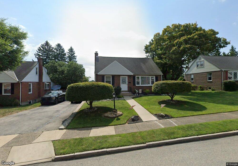
415 Barker Rd Springfield, PA 19064
Estimated Value: $461,000 - $505,000
3
Beds
2
Baths
2,118
Sq Ft
$231/Sq Ft
Est. Value
About This Home
This home is located at 415 Barker Rd, Springfield, PA 19064 and is currently estimated at $488,450, approximately $230 per square foot. 415 Barker Rd is a home located in Delaware County with nearby schools including Springfield High School and St Francis Of Assisi School.
Ownership History
Date
Name
Owned For
Owner Type
Purchase Details
Closed on
Oct 10, 2023
Sold by
Baccaro Anthony A
Bought by
Baccaro Richard Eugene
Current Estimated Value
Purchase Details
Closed on
Jun 13, 1975
Sold by
Baccaro Anthony and Baccaro Alice
Bought by
Baccaro Anthony and Baccaro Alice
Create a Home Valuation Report for This Property
The Home Valuation Report is an in-depth analysis detailing your home's value as well as a comparison with similar homes in the area
Home Values in the Area
Average Home Value in this Area
Purchase History
| Date | Buyer | Sale Price | Title Company |
|---|---|---|---|
| Baccaro Richard Eugene | -- | None Listed On Document | |
| Baccaro Richard Eugene | -- | None Listed On Document | |
| Baccaro Anthony | $40,400 | -- |
Source: Public Records
Tax History
| Year | Tax Paid | Tax Assessment Tax Assessment Total Assessment is a certain percentage of the fair market value that is determined by local assessors to be the total taxable value of land and additions on the property. | Land | Improvement |
|---|---|---|---|---|
| 2025 | $8,081 | $287,510 | $95,010 | $192,500 |
| 2024 | $8,081 | $287,510 | $95,010 | $192,500 |
| 2023 | $7,781 | $287,510 | $95,010 | $192,500 |
| 2022 | $7,613 | $287,510 | $95,010 | $192,500 |
| 2021 | $11,790 | $287,510 | $95,010 | $192,500 |
| 2020 | $6,754 | $149,040 | $45,670 | $103,370 |
| 2019 | $6,595 | $149,040 | $45,670 | $103,370 |
| 2018 | $6,501 | $149,040 | $0 | $0 |
| 2017 | $6,350 | $149,040 | $0 | $0 |
| 2016 | $818 | $149,040 | $0 | $0 |
| 2015 | $835 | $149,040 | $0 | $0 |
| 2014 | $818 | $149,040 | $0 | $0 |
Source: Public Records
Map
Nearby Homes
- 227 E Leamy Ave
- 332 Franklin Ave
- 493 Wheatsheaf Rd
- 364 S Rolling Rd
- 933 Greenbriar Ln
- 31 Wayfield Rd
- 114 Providence Rd
- 226 Lynbrooke Rd
- 978 Westfield Rd
- 507 School St
- 1299 Country Club Dr Unit Q141
- 111 Forest Rd
- 111 Broad St
- 1291 Country Club Dr Unit Q137
- 1433 Country Club Dr Unit T214
- 173 Rambling Way
- 838 West Ave
- 7 & 0 Woodland Ave
- 2 Yale Ave
- 120 W Springfield Rd
- 419 Barker Rd
- 409 Barker Rd
- 425 Barker Rd
- 401 Barker Rd
- 416 Barker Rd
- 420 Barker Rd
- 408 Barker Rd
- 429 Barker Rd
- 426 Barker Rd
- 435 Barker Rd
- 420 E Woodland Ave Unit 7D
- 420 E Woodland Ave Unit 5D
- 420 E Woodland Ave Unit 8D
- 420 E Woodland Ave Unit 8B
- 432 Barker Rd
- 417 Thatcher Rd
- 421 Thatcher Rd
- 411 Thatcher Rd
- 409 E Woodland Ave
- 427 Thatcher Rd
Your Personal Tour Guide
Ask me questions while you tour the home.